
The Filchner-Ronne Ice Shelf, also known as Ronne-Filchner Ice Shelf, is an Antarctic ice shelf bordering the Weddell Sea.

Wilhelm Filchner was a German army officer, scientist and explorer. He conducted several surveys and scientific investigations in China, Tibet and surrounding regions, and led the Second German Antarctic Expedition, 1911–13.

New Swabia was a disputed Antarctic claim by Nazi Germany within the Norwegian territorial claim of Queen Maud Land and is now a cartographic name sometimes given to an area of Antarctica between 20°E and 10°W in Queen Maud Land. New Swabia was explored by Germany in early 1939 and named after that expedition's ship, Schwabenland, itself named after the German region of Swabia.

The Imperial Trans-Antarctic expedition of 1914–1917 is considered to be the last major expedition of the Heroic Age of Antarctic Exploration. Conceived by Sir Ernest Shackleton, the expedition was an attempt to make the first land crossing of the Antarctic continent. After Roald Amundsen's South Pole expedition in 1911, this crossing remained, in Shackleton's words, the "one great main object of Antarctic journeyings". Shackleton's expedition failed to accomplish this objective, but became recognized instead as an epic feat of endurance.
Cape Filchner is an ice-covered cape fronting on Davis Sea, 17 miles west-northwest (WNW) of Adams Island. Cape Filchner is located at 66°27′S91°54′E. Cape Filchner is the division between Wilhelm II Coast and Queen Mary Coast. Cape Filchner was discovered by the Australian Antarctic Expedition (1911-1914) under Sir Douglas Mawson, who named it for Wilhelm Filchner, leader of the German Antarctic Expedition of 1911-1912.

Luitpold Coast is that portion of the coast of Coats Land extending from the vicinity of Hayes Glacier, at 27°54′W, to 36°W, which is regarded as the eastern limit of the Filchner Ice Shelf. It was discovered by Wilhelm Filchner, leader of the Second German Antarctic Expedition, 1911–12, and named after Luitpold, Prince Regent of Bavaria.

The Second German Antarctic Expedition of 1911–1913 was led by Wilhelm Filchner in the exploration ship Deutschland. Its principal objective was to determine whether the Antarctic continent comprised a single landmass rather than separated elements, and in particular whether the Weddell Sea and Ross Sea were connected by a strait. In addition, an extensive programme of scientific research was undertaken. The expedition failed to establish a land base, and the ship became beset in the Weddell Sea ice, drifting north for eight months before reaching open water. The expedition was marred by considerable disagreement and animosity among its participants, and broke up in disarray.
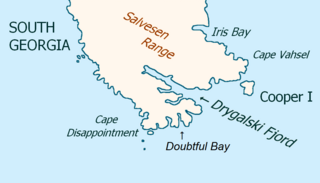
Cape Vahsel is a headland forming the eastern tip of South Georgia. It was roughly charted by Captain James Cook in 1775, remapped by the Second German Antarctic Expedition under Wilhelm Filchner, 1911–12, and named for Captain Richard Vahsel, master of the expedition ship Deutschland.
Penck Glacier is a small glacier flowing northward along the west side of Bertrab Nunatak to Vahsel Bay. Discovered by the German Antarctic Expedition, 1911–12, under Wilhelm Filchner, who named this feature for German geographer Albrecht Penck.
Schweitzer Glacier is a glacier which drains west along the north side of Littlewood Nunataks into Vahsel Bay. The Lerchenfeld Glacier, trending west-northwestward, coalesces with the lower portion of this glacier. Discovered by the German Antarctic Expedition, 1911–12, under Wilhelm Filchner. He named it for Major Schweitzer, first president of the German Antarctic Expedition Society.

New South Greenland, sometimes known as Morrell's Land, was an appearance of land recorded by the American captain Benjamin Morrell of the schooner Wasp in March 1823, during a sealing and exploration voyage in the Weddell Sea area of Antarctica. Morrell provided precise coordinates and a description of a coastline which he claimed to have sailed along for more than 300 miles (480 km). Because the Weddell Sea area was so little visited and hard to navigate due to ice conditions, the alleged land was never properly investigated before its existence was emphatically disproved during Antarctic expeditions in the early 20th century.

Vahsel Glacier is a glacier on the northwestern side of Heard Island in the southern Indian Ocean. It flows west into South West Bay, between Erratic Point and Cape Gazert. Immediately to the north of Vahsel Glacier is Schmidt Glacier, whose terminus is located between Mount Drygalski and North West Cornice. To the south of Vahsel Glacier is Allison Glacier, whose terminus is located south of Cape Gazert, which separates Allison Glacier from Vahsel Glacier. Click here to see a map of Vahsel Glacier and the northwestern coast of Heard Island.
Lewald Glacier is a small glacier 3 nautical miles (6 km) west of Cape Vahsel, flowing northward to the coast at the east end of South Georgia. It was named by the Second German Antarctic Expedition, 1911–12, under Wilhelm Filchner, for Theodor Lewald, Ministerialdirektor im Reichsamt des Innern, Germany, who took an active interest in the expedition.

Posadowsky Glacier is a glacier about 9 nautical miles long, flowing north to Posadowsky Bay immediately east of Gaussberg. Posadowsky Bay is an open embayment, located just east of the West Ice Shelf and fronting on the Davis Sea in Kaiser Wilhelm II Land. Kaiser Wilhelm II Land is the part of East Antarctica lying between Cape Penck, at 87°43'E, and Cape Filchner, at 91°54'E, and is claimed by Australia as part of the Australian Antarctic Territory. Other notable geographic features in this area include Drygalski Island, located 45 mi NNE of Cape Filchner in the Davis Sea, and Mirny Station, a Russian scientific research station.
The Filchner Rocks are a group of rocks, some of which are submerged, 4 nautical miles (7 km) northeast of Cape Vahsel, off the east end of South Georgia. The existence of these rocks was reported in 1775 by a British expedition under James Cook. They were charted by the Second German Antarctic Expedition, 1911–12, and named for Dr. Wilhelm Filchner, leader of the expedition.
Lerchenfeld Glacier is a glacier flowing in a west-northwesterly direction between Bertrab Nunatak and the Littlewood Nunataks in Antarctica. It coalesces with the southern flank of Schweitzer Glacier before the combined flow discharges into the head of Vahsel Bay. The glacier was discovered by the Second German Antarctic Expedition, 1911–12, under Wilhelm Filchner, who named this feature for Count Hugo von und zu Lerchenfeld-Köfering, a supporter of the expedition.

Felix König was an Austrian scientist, alpinist and Antarctic explorer. He was a member of Wilhelm Filchner's Second German Antarctic Expedition, 1911–13, which failed in its attempt to determine the nature of the link, if any, between the Weddell Sea and the Ross Sea, and thereby resolve the question as to whether the continent was a single landmass or a group of several elements. In the course of the expedition König, along with Filchner, was part of the group, that disproved the existence of the land known as New South Greenland, or "Morrell's Land", supposedly discovered in 1823 by the American sealer captain, Benjamin Morrell.

Richard Vahsel was a German naval officer who served as second officer on the Antarctic Gauss expedition, under command of Erich von Drygalski. In 1911, Vahsel was controversially appointed as captain of the Deutschland, on Wilhelm Filchner's Second German Antarctic Expedition, 1911–1913. Vahsel and Filchner proved incompatible, and the failure of their relationship fatally undermined the chances of the expedition's success.
Heinrich Seelheim was a German geographer and diplomat, who was a member of Wilhelm Filchner's Second German Antarctic Expedition in 1911–13. In 1910, to gain polar travel experience, he participated with Filchner and others in a trial expedition to Spitsbergen. He was in charge of the first leg of the Antarctic expedition, between Germany and Buenos Aires, while Filchner remained in Germany. Seelheim resigned from the expedition in Buenos Aires, because of disputes with the ship's captain, Richard Vahsel. After the First World War, Seelheim entered the diplomatic service, and was subsequently German consul in Winnipeg, Canada, and Yokohama, Japan.

Deutschland, known as Bjørn between 1905 and 1909, and Osterreich between 1914 and 1917, was a Norwegian whaling and sealing ship, built in 1905. She is best known for her role as the expedition ship in the Second German Antarctic Expedition of 1911–13. During this expedition she was taken further south in the Weddell Sea than any previous vessel in those waters, but became trapped, surviving an eight-months long drift in heavy ice before being freed. After the expedition she was sold to Austria as the basis for another planned Antarctic expedition, but this was cancelled on the outbreak of the First World War in August 1914. The ship served in the Austro-Hungarian Navy as a minesweeper until 1917, when she was sunk in a torpedo attack.
