With an area of 238,400 square kilometers, Romania is the twelfth-largest country in Europe. Located in Southeastern Europe, bordering on the Black Sea, the country is halfway between the equator and the North Pole and equidistant from the westernmost part of Europe—the Atlantic Coast—and the most easterly—the Ural Mountains. Romania has 3,195 kilometers of border. Republic of Moldova and Ukraine lie to the east, Bulgaria lies to the south, and Serbia and Hungary to the west. In the southeast, 245 kilometers of sea coastline provide an important outlet to the Black Sea and the Atlantic Ocean.
The Megleno-Romanians, Moglenite Vlachs or simply Meglenites or Vlachs are a small Eastern Romance people, originally inhabiting seven villages in the Moglena region spanning the Pella and Kilkis regional units of Central Macedonia, Greece, and one village, Huma, across the border in North Macedonia. This people lives in an area of approximately 300 km2 in size. Unlike the Aromanian Vlachs, the other Romance speaking population in the same historic region, the Meglen Vlachs are traditionally sedentary agriculturalists, and not traditionally transhumants.

Pleven Province is a province located in central northern Bulgaria, bordering the Danube river, Romania and the Bulgarian provinces of Vratsa, Veliko Tarnovo and Lovech. It is divided into 11 subdivisions, called municipalities, that embrace a territory of 4,333.54 km² with a population, as of February 2011, of 269 752 inhabitants. The province's capital is the city of Pleven.
Vama Veche is a village in Constanţa County, Romania, on the Black Sea coast, near the border with Bulgaria, at 28.57 E longitude, 43.75 N latitude. It is part of the commune of Limanu and in 2002, it had a population of 178.

Negru Vodă is a town in Constanța County, Dobruja, south-eastern Romania. The town is close to the border with Bulgaria and there is a border crossing linking Negru Vodă to the Bulgarian village Kardam.
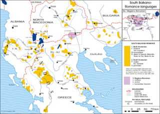
Megleno-Romanian is an Eastern Romance language, similar to Aromanian or a dialect of the Romanian language. It is spoken by the Megleno-Romanians in a few villages in the Moglena region that spans the border between the Greek region of Macedonia and North Macedonia. It is also spoken by emigrants from these villages and their descendants in Romania and by a small Muslim group in Turkey. It is considered an endangered language.

Opaka is a town in Targovishte Province in northeast Bulgaria. As of December 2009, the town had a population of 2,873 and covers an area of 57 square kilometres (22 sq mi). It is 70 kilometres (43 mi) south of the city of Rousse on the border with Romania and 250 kilometres (160 mi) northeast of the Bulgarian capital, Sofia. Archeologists have found evidence of Thracian, Roman and Slavonic settlements in the area. Near the village of Krepcha, a stone monastery is the site of the oldest known Old Bulgarian Cyrillic inscription, dated from around 920 CE. A 2nd century Thracian tumulus containing various artifacts, including six leaves of a golden wreath and bronze figurines, was excavated in 2011.
The Ludogorie or Deliorman, all meaning "region of mad forests", is a region in northeastern Bulgaria stretching over the plateau of the same name. Major cities in the region are Razgrad, Novi Pazar, Pliska and Isperih. Part of the Danubian Plain, the region is hilly in the east, reaching up to 485.70 metres (1,593.5 ft) in height near the village of Samuil, but merges with the plains of Dobruja and the Danube to the north, with the lowest point near Yuper. The region is bordered to the west by the Provadiya River and the Beli Lom; to the east it transitions into the Dobruja plateau.

The Danube Bridge is a steel truss bridge over the Danube River connecting the Bulgarian bank to the south with the Romanian bank to the north and the cities of Ruse and Giurgiu respectively. It is one of only two bridges connecting Romania and Bulgaria, the other one being the New Europe Bridge between the cities of Vidin and Calafat. The Danube bridge can be reached by using public transport - bus lines 4,11,12 and 28.

Voyvodovo is a village in Miziya municipality, Vratsa Province, Bulgaria, at 43°39′N23°51′E. It was founded in 1900, mostly by Evangelist Czechs, but also by Slovaks, Banat Swabians and Banat Bulgarians, all settlers from the region of Banat, then in Austria-Hungary.
Godech is a small town located in the Sofia Province, of Bulgaria. The town is founded in a valley on the far west of Stara Planina, where the Nishava River passes. The settlement is about 20 km east of the Serbian border and has its highest peak Kom to the north. Godech is officially a town with 4,663 inhabitants. It is the administrative center of the Godech municipality.

Limanu is a commune in Constanța County, Romania.

Tervel is a town in northeastern Bulgaria, part of Dobrich Province. It is the administrative centre of Tervel Municipality, which lies in the westernmost part of the province. As of December 2009, the town has a population of 6,667 inhabitants.
Kaynardzha is a village in northeastern Bulgaria, part of Silistra Province. It is the administrative centre of Kaynardzha Municipality, which lies in the easternmost part of Silistra Province, in the historical region of Southern Dobruja, close to the Romanian border.

Chirsova is a commune and village in the Gagauz Autonomous Territorial Unit of the Republic of Moldova. The 2004 census listed the commune as having a population of 6,861 people. Gagauz total 3,128, Bulgarians - 3,326. Minorities included 156 Moldovans, 119 Russians, 98 Ukrainians, 1 Romanian, 9 Roma and 24 'other nationality'.
Karapelit is a village in the municipality of Dobrichka, in Dobrich Province, in northeastern Bulgaria.
Vedrina is a village in the municipality of Dobrichka, in Dobrich Province, in northeastern Bulgaria.
Petleshkovo is a village in General Toshevo Municipality, Dobrich Province, in northeastern Bulgaria.
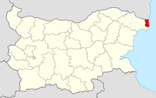
Kardam is a village in General Toshevo Municipality, Dobrich Province, in northeastern Bulgaria. Kardam is close to the border with Romania and there is a border crossing linking the village to the Romanian town Negru Vodă.