Val Verde County Airport

Last updated
Val Verde County Airport

Del Rio Field
Val Verde County Airport - Texas.jpg
Val Verde County Airport – Texas, 26 October 1943
Summary
Built1919
In use1919–1959
Coordinates 29°22′37″N100°49′12″W / 29.37694°N 100.82000°W / 29.37694; -100.82000 (Val Verde County Airport)
Map
USA Texas location map.svg
Airplane silhouette.svg
Val Verde County Airport
Val Verde County Airport, Texas
Val Verde County Airport
Runways
Direction LengthSurface
ftm
09/275,2001,585Asphalt
12/303,3761,029Asphalt
04/224,8511,479Asphalt

Val Verde County Airport is a former airport, located in Del Rio, Texas. Airport operations ended in 1959. Today the former airport is a residential site.

Contents

History

The airport was established by the Air Service, United States Army in 1919 as a military airfield. It was constructed as a base for observation overflights along the Mexican Border. During this period, Mexico was enduring a period of revolution and unrest, which led to border violations and the deaths of American citizens.

Flight "A" of the 90th Squadron (Surveillance) arrived at Del Rio Field on 12 June 192with de Havilland DH-4 aircraft, and flew observation missions along the border. [1] The 90th operated from Del Rio until the Border Patrol operation ended in June 1921. [1]

The next use of the airfield was when the Department of Commerce refitted the facility as one of its network of Intermediate Landing Fields, which were established in the 1920s & 1930s to serve as emergency landing fields along commercial airways between major cities. It was opened in November 1937 as Val Verde County Airport. On September 26, 1942, during World War II, the airport was taken over by the United States Army Air Forces and used as a contract primary pilot training airfield under the AAF Gulf Coast Training Center (later Central Flying Training Command). Flying training was performed with Fairchild PT-19s as the primary trainer. Also had several PT-17 Stearmans and a few P-40 Warhawks assigned. The training school was inactivated at the end of the war, and the airport was returned to civil control on January 11, 1946. [2] [3] [4]

During the postwar years, the airport remained dormant. It was re-activated by the United States Air Force in 1952 as an auxiliary landing airfield supporting the pilot training mission of Laughlin AFB. In 1958 it was re-designated Laughlin Service Annex, and was disposed of in 1959. [5]

Val Verde County Airport was presumably never reused after that point for civilian aviation, undoubtedly caused by its proximity to Laughlin AFB. The land was sold to private developers and houses and streets began to be overlaid over the former airport. [5] However, the runways remained visible in aerial photography over the years, with some of the runways being converted into streets. Today, some of the old runways remain abandoned but quite visible in aerial imagery.

See also

Related Research Articles

<span class="mw-page-title-main">Laughlin Air Force Base</span> US Air Force base near Del Rio, Texas

Laughlin Air Force Base is a facility of the United States Air Force located east of Del Rio, Texas.

<span class="mw-page-title-main">Hunter Army Airfield</span> Military airfield near Hinesville, Georgia, US

Hunter Army Airfield, located in Savannah, Georgia, United States, is a military airfield and subordinate installation to Fort Stewart located in Hinesville, Georgia.

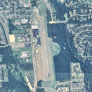
Del Rio International Airport is two miles northwest of Del Rio, in Val Verde County, Texas, United States. It is used for general aviation, and, being near Laughlin Air Force Base, it is often used by USAF students during training flights.

<span class="mw-page-title-main">Majors Airport</span> Airport in Hunt County, Texas

Majors Airport is a city-owned airport 4 nautical miles (7.4 km) southeast of the central business district of Greenville, in Hunt County, Texas.

<span class="mw-page-title-main">Lawson Army Airfield</span> United States military installation

Lawson Army Airfield is a military airport located at Fort Moore in Chattahoochee County, Georgia, south of the city of Columbus, Georgia. It is Fort Moore's primary force projection platform.

<span class="mw-page-title-main">Ellington Field Joint Reserve Base</span> Installation of several military units

Ellington Field Joint Reserve Base is a joint installation shared by various active component and reserve component military units, as well as aircraft flight operations of the National Aeronautics and Space Administration (NASA) under the aegis of the nearby Johnson Space Center. The host wing for the installation is the Texas Air National Guard's 147th Attack Wing. Opened in 1917, Ellington Field was one of thirty-two Air Service training camps established after the United States entry into World War I. It is named for First Lieutenant Eric Ellington, a U.S. Army aviator who was killed in a plane crash in San Diego, California in 1913.

<span class="mw-page-title-main">Daniel Field</span> Airport

Daniel Field is a public use airport located one nautical mile (2 km) west of the central business district of Augusta, a city in Richmond County, Georgia, United States. It is owned by the City of Augusta and operated by the General Aviation Commission. This airport is included in the National Plan of Integrated Airport Systems for 2021–2025, which categorized it as a general aviation facility.

<span class="mw-page-title-main">Eric Marcus Municipal Airport</span> Airport in Pima County, Arizona

Eric Marcus Municipal Airport is a county-owned, public-use airport in Pima County, Arizona, United States. It is located 5.75 miles north of the central business district of Ajo and is about 82 miles southwest of Phoenix. The airport was renamed on February 11, 2006; it was formerly known as Ajo Municipal Airport.

<span class="mw-page-title-main">Marlboro County Jetport</span> Airport in Marlboro County, South Carolina

Marlboro County Jetport, also known as H.E. Avent Field, is a county-owned public-use airport located 3 nautical miles west of the central business district of Bennettsville, in Marlboro County, South Carolina, United States.

<span class="mw-page-title-main">Dalhart Army Air Base</span> Airport

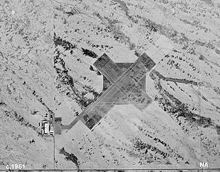
Dalhart Army Air Base is a former World War II military airfield complex near the city of Dalhart, Texas. It operated three training sites for the United States Army Air Forces from 1943 until 1945.

<span class="mw-page-title-main">Malden Regional Airport</span> Airport in Dunkin County, Missouri

Malden Regional Airport is a city-owned, public-use airport located three nautical miles (6 km) north of the central business district of Malden, a city in Dunklin County, Missouri, United States. This airport is included in the National Plan of Integrated Airport Systems, which categorized it as a general aviation facility.

<span class="mw-page-title-main">Echeverria Field</span> WWII-era USAAF airfield in Arizona

Echeverria Field is an abandoned airfield, located approximately 15 miles (24 km) west of Wickenburg, Arizona.

<span class="mw-page-title-main">Thompson–Robbins Airport</span> Airport in Phillips County, Arkansas

Thompson–Robbins Airport is 6 miles (9.7 km) northwest of the center of Helena–West Helena, in unincorporated Phillips County, Arkansas, United States. It is owned by the city of Helena–West Helena.

<span class="mw-page-title-main">Eagle Field (airport)</span> Airport in Fresno County, California

Eagle Field is a privately owned, private use airport in Fresno County, California, United States. It is located seven nautical miles southwest of the central business district of Dos Palos, a city in neighboring Merced County.

<span class="mw-page-title-main">Bruce Field</span> Airport

Bruce Field is a city-owned public-use general aviation airport located five nautical miles southwest of the central business district of Ballinger, a city in Runnels County, Texas, United States.

<span class="mw-page-title-main">W. R. Byron Airport</span> Airport in Riverside County, California

W. R. Byron Airport is a privately owned, private use airport in Riverside County, California, United States. It is located four nautical miles northwest of the central business district of Blythe, California, within the city limits.

<span class="mw-page-title-main">Arledge Field</span> Airport in Jones County, Texas

Arledge Field is a public general aviation airport located approximately 4 miles (6.4 km) east of Stamford, Texas. Owned by the city of Stamford, it provides general aviation service. Approximately 80 aircraft use the airport on a weekly basis.

<span class="mw-page-title-main">Bruce Campbell Field</span> Airport in Madison County, Mississippi

Bruce Campbell Field is a city-owned public-use airport located two nautical miles (4 km) southeast of the central business district of Madison, a city in Madison County, Mississippi, United States. This airport is included in the National Plan of Integrated Airport Systems for 2011–2015, which categorized it as a general aviation airport.

<span class="mw-page-title-main">Eagle Pass Army Airfield</span> World War II US military installation

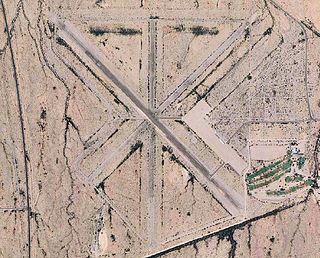
Eagle Pass Army Airfield is a former World War II military airfield complex. It is located 10.6 miles (17.1 km) north of Eagle Pass, Texas. It operated as a training base for the United States Army Air Forces from 1943 until 1945.

<span class="mw-page-title-main">Eagle Pass Municipal Airport</span> Airport

Eagle Pass Municipal Airport is a former airport, located in Eagle Pass, Texas. Airport operations ended around 1998, being transferred to the Maverick County Memorial International Airport. Today the former airport is a commercial site.

References

PD-icon.svg This article incorporates public domain material from the Air Force Historical Research Agency

  1. 1 2 "AFHRA 90th Fighter Squadron". Archived from the original on 2011-09-14. Retrieved 2011-11-20.
  2. PD-icon.svg This article incorporates public domain material from the Air Force Historical Research Agency
  3. Manning, Thomas A. (2005), History of Air Education and Training Command, 1942–2002. Office of History and Research, Headquarters, AETC, Randolph AFB, Texas OCLC   71006954 , 29991467
  4. Shaw, Frederick J. (2004), Locating Air Force Base Sites, History’s Legacy, Air Force History and Museums Program, United States Air Force, Washington DC. OCLC   57007862 , 1050653629
  5. 1 2 Abandoned Airfields: Val Verde County Airport