Related Research Articles

The Engadin or Engadine is a long high Alpine valley region in the eastern Swiss Alps in the canton of Graubünden in southeasternmost Switzerland with about 25,000 inhabitants. It follows the route of the Inn from its headwaters at Maloja Pass in the southwest running roughly northeast until the Inn flows into Austria, one hundred kilometers downstream. The En/Inn subsequently flows at Passau into the Danube, making it the only Swiss river to drain into the Black Sea. The Engadine is protected by high mountain ranges on all sides and is famous for its sunny climate, beautiful landscapes and outdoor activities.
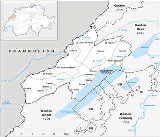
The Republic and Canton of Neuchâtel is a French-speaking canton in western Switzerland. In 2007, its population was 169,782, of whom 39,654 were foreigners. The capital is Neuchâtel.

The legal drinking age is the minimum age at which a person can legally consume alcoholic beverages. The minimum age alcohol can be legally consumed can be different from the age when it can be purchased in some countries. These laws vary between countries and many laws have exemptions or special circumstances. Most laws apply only to drinking alcohol in public places with alcohol consumption in the home being mostly unregulated. Some countries also have different age limits for different types of alcohol drinks.

The Vorderrhein is one of the two sources of the Rhine. Its catchment area of 1,512 square kilometres is located predominantly in the canton of Graubünden (Switzerland). The Vorderrhein is about 76 kilometres (47 mi) long, thus more than 5% longer than the Hinterrhein/Rein Posteriur. The Vorderrhein, however, has an average water flow of 53.8 m3/s (1,900 cu ft/s), which is less than the flow of the Hinterrhein. According to the Atlas of Switzerland of the Swiss Federal Office of Topography, the source of the Vorderrhein– and the Rhine –is located north of the Rein da Tuma and Lake Toma.
Val-de-Travers District was one of the six districts of the canton of Neuchâtel, Switzerland, until the district level was eliminated on 1 January 2018. It is famous for its clock industry. The Canton is largely rural and farming remains important, but it also had significant industry from the 17th century due to the hydro-power available at St Sulpice, and Asphalt was mined from 1711 to 1986 at Travers.

Sumvitg is a municipality in the Surselva Region in the canton of Graubünden in Switzerland.

The Battle of Calven took place on May 22, 1499 at the exit of the Val Müstair in the Grisons to the Vinschgau in County of Tyrol between the forces of King Maximilian I of the House of Habsburg and those of the free federation of the Three Leagues of the Grisons. It was the decisive battle in the southern Grisons of the Swabian War; after the defeat of the Habsburg troops, the king had to abandon his attempts to control the Engadin and the Val Müstair. The focus of operations in the Swabian War subsequently shifted again to the northern border of the Old Swiss Confederacy.
The Valle Mesolcina, also known as the Val Mesolcina or Misox (German), is an alpine valley of the Grisons, Switzerland, stretching from the San Bernardino Pass to Grono where it joins the Calanca Valley. It is the valley formed by the river Moesa.
Kępy is a village in the administrative district of Gmina Wądroże Wielkie, within Jawor County, Lower Silesian Voivodeship, in south-western Poland. Prior to 1945 it was in Germany.

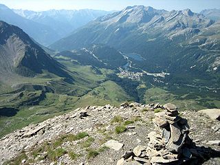
Val Poschiavo is a valley in the southern, Italian-speaking part of the Swiss canton of Graubünden (Grisons). The main town is Poschiavo.

Nowosiółki Kardynalskie is a village in the administrative district of Gmina Lubycza Królewska, within Tomaszów Lubelski County, Lublin Voivodeship, in eastern Poland, close to the border with Ukraine. It lies approximately 18 kilometres (11 mi) south-east of Tomaszów Lubelski and 122 km (76 mi) south-east of the regional capital Lublin. The village is located in the historical region Galicia.
Sfazù is a hamlet in the upper part of the Val Poschiavo in the canton of Graubünden, Switzerland. It lies at 1,622 metres (5,322 ft) above sea level at the point where the Val da Camp enters the Val Poschiavo. It is on the southern approach to the Bernina Pass, and is in the municipality of Poschiavo, some 7.5 kilometres (4.7 mi) north of the village of the same name. Because of the 600 metres (2,000 ft) of altitude difference between the two villages, the distance between them by road is 9 kilometres (5.6 mi), using Hauptstrasse 29 that passes close by Sfazù.
Jabłonka is a settlement in the administrative district of Gmina Trzciel, within Międzyrzecz County, Lubusz Voivodeship, in western Poland. It lies approximately 3 kilometres (2 mi) north of Trzciel, 21 km (13 mi) east of Międzyrzecz, 57 km (35 mi) north-east of Zielona Góra, and 58 km (36 mi) south-east of Gorzów Wielkopolski.
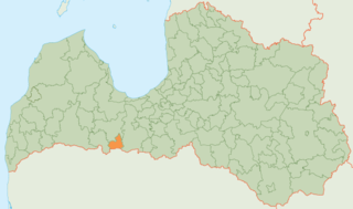
Tērvete Municipality is a municipality in Zemgale, Latvia. The municipality was formed in 2002 by merging Augstkalne parish, Bukaiši parish and Tērvete parish, the administrative centre being Zelmeņi. The population in 2020 was 3,302.

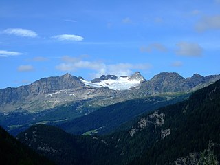
The Tschierva Hut is a mountain hut located in the Swiss canton of Graubünden at the foot of Piz Bernina, Piz Tschierva and Piz Morteratsch at the end of Val Roseg. The hut lies at 2,584 metres above sea level near the Tschierva Glacier and can be accessed from Pontresina via a trail. The hut is the starting point of the Biancograt, the serpentine north ridge of Piz Bernina.

The Rein da Medel is the longest headwater of the Rhine. It is located in the Swiss cantons of Ticino and Graubünden and flows through the valleys Val Cadlimo and Val Medel. Rein da Medel is the local Sursilvan, name in Graubünden, which is commonly used to denote the Ticino part as well.

The Fimbatal, also Fimbertal, is an alpine valley situated between the Silvretta Alps and the Samnaun Alps. The valley is drained by the Fimbabach river, a tributary of the Inn basin (Trisanna) at Ischgl. The highest mountain bordering the Fimbatal is the Fluchthorn.

The Heidelberger Hut is a mountain hut located in the Silvretta in the Swiss canton of Graubünden. It lies at an altitude of 2,264 metres above sea level in the Val Fenga.
Surselva Region is one of the eleven administrative districts in the canton of Graubünden in Switzerland. It was created on 1 January 2017 as part of a reorganization of the canton.
References
- ↑ "Val da Camp - Wanderland". www.schweizmobil.ch (in German). Retrieved 2018-07-02.
- ↑ "Puschlav: Wandern im Val da Camp und zum Saoseo-See". Bergell_Blog (in German). Retrieved 2018-07-02.
- ↑ "Sfazù - Sfazù". outdooractive. Retrieved 2018-07-02.
- ↑ Lindenmayer, Clem (1996). Walking in Switzerland . Lonely Planet Publications. ISBN 9780864423276.
sfazu.