Abel Janszoon Tasman was a Dutch seafarer and explorer, best known for his voyages of 1642 and 1644 in the service of the Dutch East India Company (VOC).

Captain James Cook was a British explorer, cartographer and naval officer famous for his three voyages between 1768 and 1779 in the Pacific Ocean and to New Zealand and Australia in particular. He made detailed maps of Newfoundland prior to making three voyages to the Pacific, during which he achieved the first recorded European contact with the eastern coastline of Australia and the Hawaiian Islands and the first recorded circumnavigation of New Zealand.

Terra Australis was a hypothetical continent first posited in antiquity and which appeared on maps between the 15th and 18th centuries. Its existence was not based on any survey or direct observation, but rather on the idea that continental land in the Northern Hemisphere should be balanced by land in the Southern Hemisphere. This theory of balancing land has been documented as early as the 5th century on maps by Macrobius, who uses the term Australis on his maps.

The maritime European exploration of Australia consisted of several waves of European seafarers who sailed the edges of the Australian continent. Dutch navigators were the first Europeans known to have explored and mapped the Australian coastline. The first documented encounter was that of Dutch navigator Willem Janszoon, in 1606. Dutch seafarers also visited the west and north coasts of the continent, as did French explorers.

New Holland is a historical European name for mainland Australia.
The Mahogany Ship is a putative early Australian shipwreck that is believed by some to lie beneath the sand in the Armstrong Bay area, approximately 3 to 6 kilometres west of Warrnambool in southwest Victoria, Australia. In many modern accounts it is described as a Spanish or Portuguese caravel after the wreck was associated with the theory of Portuguese discovery of Australia by Kenneth McIntyre in his 1977 book The Secret Discovery of Australia. The most recent research has questioned this theory and provided other explanations.

The Dieppe maps are a series of world maps and atlases produced in Dieppe, France, in the 1540s, 1550s, and 1560s. They are large hand-produced works, commissioned for wealthy and royal patrons, including Kings Henry II of France and Henry VIII of England. The Dieppe school of cartographers included Pierre Desceliers, Jean Rotz, Guillaume Le Testu, Guillaume Brouscon and Nicolas Desliens.

The theory of Portuguese discovery of Australia claims that early Portuguese navigators were the first Europeans to sight Australia between 1521 and 1524, well before the arrival of Dutch navigator Willem Janszoon in 1606 on board the Duyfken who is generally considered to be the first European discoverer. While lacking generally accepted evidence, this theory is based on the following:
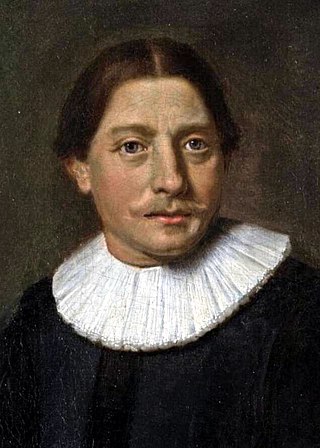
Cristóvão de Mendonça was a Portuguese noble and explorer who was active in South East Asia in the 16th century.
The earliest known world maps date to classical antiquity, the oldest examples of the 6th to 5th centuries BCE still based on the flat Earth paradigm. World maps assuming a spherical Earth first appear in the Hellenistic period. The developments of Greek geography during this time, notably by Eratosthenes and Posidonius culminated in the Roman era, with Ptolemy's world map, which would remain authoritative throughout the Middle Ages. Since Ptolemy, knowledge of the approximate size of the Earth allowed cartographers to estimate the extent of their geographical knowledge, and to indicate parts of the planet known to exist but not yet explored as terra incognita.
Gomes de Sequeira was a Portuguese explorer in the early 16th century. It has been suggested by some historians that Gomes de Sequeira may have sailed to the northeast coast of Australia as part of his explorations, although this is disputed.

Beyond Capricorn: How Portuguese adventurers secretly discovered and mapped Australia and New Zealand 250 years before Captain Cook is a 2007 book by journalist Peter Trickett on the theory of Portuguese discovery of Australia. Although its thesis is similar to that advanced by Kenneth McIntyre in 1977, Lawrence Fitzgerald in 1984 and others, the publisher and some news reports presented it as being a new theory on the discovery of Australia.

The first voyage of James Cook was a combined Royal Navy and Royal Society expedition to the south Pacific Ocean aboard HMS Endeavour, from 1768 to 1771. It was the first of three Pacific voyages of which James Cook was the commander. The aims of this first expedition were to observe the 1769 transit of Venus across the Sun, and to seek evidence of the postulated Terra Australis Incognita or "undiscovered southern land".

A Voyage to Terra Australis: Undertaken for the Purpose of Completing the Discovery of that Vast Country, and Prosecuted in the Years 1801, 1802, and 1803, in His Majesty's Ship the Investigator was a sea voyage journal written by British mariner and explorer Matthew Flinders. It describes his circumnavigation of the Australian continent in the early years of the 19th century, and his imprisonment by the French on the island of Mauritius from 1804 to 1810.

Regio Patalis is Latin for “the region of Patala”, that is the region around the ancient city of Patala at the mouth of the Indus River in Sindh, Pakistan. The historians of Alexander the Great state that the Indus parted into two branches at the city of Patala before reaching the sea, and the island thus formed was called Patalene, the district of Patala. Alexander constructed a harbour at Patala.
M. Moleiro Editor is a publishing house specialising in high-quality facsimile reproductions of codices, maps and illuminated manuscripts. Founded in Barcelona in 1991, the firm has reproduced many masterpieces from the history of illumination.
Early Polynesian explorers reached nearly all Pacific islands by 1200 CE, followed by Asian navigation in Southeast Asia and the West Pacific. During the Middle Ages, Muslim traders linked the Middle East and East Africa to the Asian Pacific coasts, reaching southern China and much of the Malay Archipelago. Direct European contact with the Pacific began in 1512, with the Portuguese encountering its western edges, soon followed by the Spanish arriving from the American coast.

The European exploration of Australia first began in February 1606, when Dutch navigator Willem Janszoon landed in Cape York Peninsula and on October that year when Spanish explorer Luís Vaz de Torres sailed through, and navigated, Torres Strait islands. Twenty-nine other Dutch navigators explored the western and southern coasts in the 17th century, and dubbed the continent New Holland. Most of the explorers of this period concluded that the apparent lack of water and fertile soil made the region unsuitable for colonisation.

The Vallard Atlas is a world atlas, one of the Dieppe school of maps, produced in 1547. It is believed to have been owned by Nicolas Vallard, its authorship being unknown.
