Related Research Articles

Burbank is a census-designated place (CDP) in Walla Walla County, Washington, United States, where the Snake River meets the Columbia. The population was 3,291 at the 2010 census. Named for Luther Burbank, the city is located just east of Pasco and Kennewick, across the Snake and Columbia Rivers, respectively. Burbank is part of the Tri-Cities, WA urban area, despite being located in the Walla Walla metropolitan area.

Dixie is a census-designated place (CDP) in Walla Walla County, Washington, United States. The population was 197 at the 2010 census.

Garrett is a census-designated place (CDP) in Walla Walla County, Washington, United States. The population was 1,419 at the 2010 census.

Touchet is a census-designated place (CDP) in Walla Walla County, Washington, United States. The population was 421 at the 2010 census.
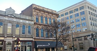
Walla Walla is the largest city and county seat of Walla Walla County, Washington, United States. It had a population of 31,731 at the 2010 census, estimated to have increased to 32,900 as of 2019. The population of the city and its two suburbs, the town of College Place and unincorporated East Walla Walla, is about 45,000.

Wallula is a census-designated place (CDP) in Walla Walla County, Washington, United States. The population was 179 at the 2010 census.

The Inland Northwest, historically and alternatively known as the Inland Empire, is a region of the American Northwest centered on the Greater Spokane Area, that includes all of Eastern Washington and North Idaho. Northeastern Oregon and Western Montana are also sometimes considered part of the Inland Northwest, but Western Montana generally is not considered part of the Inland Empire. Under some definitions, the Inland Empire also excludes Central Washington or Idaho County, Idaho.
Mullan Road was the first wagon road to cross the Rocky Mountains to the Inland of the Pacific Northwest. It was built by U.S. Army troops under the command of Lt. John Mullan, between the spring of 1859 and summer 1860. It led from Fort Benton, which at the time was in the Dakota Territory, then Idaho Territory from July 1863, and Montana Territory beginning in May 1864, and the navigational head of the Missouri River. The road connected to Fort Walla Walla, Washington Territory, near the Columbia River. The road previewed the route approximately followed of modern-day Interstate 15 and Interstate 90 through present-day Montana, Idaho, and Washington.
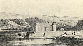
Fort Nez Percés, later known as (Old) Fort Walla Walla, was a fortified fur trading post on the Columbia River on the territory of modern-day Wallula, Washington. Despite being named after the Nez Perce people, the fort was in the traditional lands of the Walla Walla. Founded in 1818 by the North-West Company, after 1821 it was run by the Hudson's Bay Company until its closure in 1857.

The Walla Walla Valley AVA is an American Viticultural Area located within Washington state and extending partly into the northeastern corner of Oregon. The wine region is entirely included within the larger Columbia Valley AVA. In addition to grapes, the area produces sweet onions, wheat and strawberries. After the Yakima Valley AVA, the Walla Walla AVA has the second highest concentration of vineyards and wineries in Washington State. Walla Walla hosts about 140 wineries.

Lowden is an unincorporated community in Walla Walla County, Washington, United States. Originally an early Pacific Northwest mixed ancestry settlement called Frenchtown sometimes referred as a French Canadian or a Métis settlement, it was renamed in 1915 after local farmer and rancher Francis M. Lowden. It lies along U.S. Route 12 between Wallula and Walla Walla. Dunning Irrigation, Woodward Canyon Winery, l'Ecole 41 Winery and many family farm operations are located in Lowden.
Walla Walla Community College (WWCC) is a multi-campus community college in southeastern Washington state.

Umapine is a census-designated place and unincorporated community in Umatilla County, Oregon, United States, two miles from the Oregon-Washington border. The traditional boundary covers a wide area. It has a population of 315 people as of 2010. The community is part of the Pendleton–Hermiston Micropolitan Statistical Area. The current economy is supported by agriculture, including wheat and hay farms, apple orchards, and an increasing number of vineyards. The main establishments in the town are Tate's Umapine Market, The Umapine Creamery and the Waterhole Tavern.
Attalia is an extinct town in Walla Walla County, Washington. The GNIS classifies it as a populated place. Attalia was located on the East shore of the Columbia River some 8 miles downriver from Burbank.
Siverly is an unincorporated community in Swan Township, Vinton County, Ohio, in the United States.
Eureka is an unincorporated community in Walla Walla County, in the U.S. state of Washington.
Penrith is an unincorporated community in Pend Oreille County, in the U.S. state of Washington.
Pleasant View is an extinct town in Walla Walla County, in the U.S. state of Washington.
Russell is an unincorporated community in Walla Walla County, in the U.S. state of Washington.
Whitman is an unincorporated community in Walla Walla County, in the U.S. state of Washington.
References
- ↑ U.S. Geological Survey Geographic Names Information System: Valley Grove, Washington
- ↑ Meany, Edmond S. (1923). Origin of Washington geographic names. Seattle: University of Washington Press. p. 324.
- ↑ "Post Offices". Jim Forte Postal History. Retrieved 27 August 2016.
Municipalities and communities of Walla Walla County, Washington, United States | ||
|---|---|---|
| Cities |  | |
| CDPs | ||
| Unincorporated communities | ||
| Ghost towns | ||
Coordinates: 46°09′08″N118°20′56″W / 46.15222°N 118.34889°W
| | This Walla Walla County, Washington state location article is a stub. You can help Wikipedia by expanding it. |