
Robertson County is a county in the U.S. state of Texas. As of the 2020 census, its population was 16,757. Its county seat is Franklin. The county was created in 1837 and organized the following year. It is named for Sterling C. Robertson, an early settler who signed the Texas Declaration of Independence.

Falls County is a county in the U.S. state of Texas. As of the 2020 census, its population was 16,968. The county seat is Marlin. It is named for the original 10-foot-tall waterfall on the Brazos River, which existed until the river changed course during a storm in 1866. The present falls is two miles northeast of the original falls, at the Falls on the Brazos Park, a camping site only a few miles out of Marlin on Farm to Market Road 712.

Brazos County is a county in the U.S. state of Texas. As of the 2020 census, its population was 233,849. The county seat is Bryan. Along with Brazoria County, the county is named for the Brazos River, which forms its western border. The county was formed in 1841 and organized in 1843.
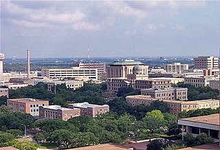
College Station is a city in Brazos County, Texas, United States, situated in East-Central Texas in the Brazos Valley, towards the eastern edge of the region known as the Texas Triangle. It is 83 miles northwest of Houston and 87 miles (140 km) east-northeast of Austin. As of the 2020 census, College Station had a population of 120,511. College Station and Bryan make up the Bryan-College Station metropolitan area, the 15th-largest metropolitan area in Texas with 268,248 people as of 2020.

Bardwell is a city in Ellis County, Texas, United States. The population was 625 at the 2020 census.

Cameron is a city in Milam County, Texas, United States. Its population was 5,306 at the 2020 census. It is the county seat of Milam County.

Normangee is a town in Leon and Madison counties in Texas, United States. Its population is 495 as of 2020.

Cosham railway station serves Cosham, a northern suburb of the city of Portsmouth, Hampshire in southern England. It is 90 miles 6 chains from London Waterloo.
Brazos Valley is a region of the U.S. state of Texas comprising the following 7 counties in Central Texas: Brazos, Burleson, and Robertson, and the neighboring counties of Grimes, Leon, Madison, and Washington.
Mumford is an unincorporated community in Robertson County, Texas, United States. It is part of the Bryan-College Station metropolitan area. Mumford is unincorporated and has no post office, with the ZIP code of 77867; the ZCTA for ZIP Code 77867 had a population of 176 at the 2000 census.
College Station–Bryan is a metropolitan area centering on the twin cities of Bryan and College Station, Texas, in the Brazos Valley region of Texas. The 2010 census placed the population of the three-county metropolitan area at 255,519. The 2019 population estimate was 273,101.

The Alabama Great Southern Railroad is a railroad in the U.S. states of Alabama, Georgia, Louisiana, Mississippi, and Tennessee. It is an operating subsidiary of the Norfolk Southern Corporation (NS), running southwest from Chattanooga to New Orleans through Birmingham and Meridian. The AGS also owns about a 30% interest in the Canadian Pacific Kansas City-controlled Meridian-Shreveport Meridian Speedway.

Dobbin is an unincorporated community in Montgomery County, Texas, United States. According to the Handbook of Texas, the community had an estimated population of 170 in 2000, although some estimates place that figure at close to 300. Dobbin is part of the Houston–Sugar Land–Baytown Metropolitan Statistical Area.
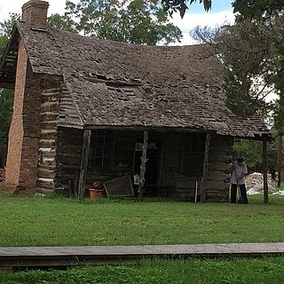
Wheelock is an unincorporated community in Robertson County, Texas, United States. It is located 15 miles (24 km) northeast of Bryan and 11 miles (18 km) southeast of Franklin. Wheelock is located on Farm to Market Road 46 and Farm to Market Road 391. It is part of the Bryan–College Station Metropolitan Statistical Area.
Nashville was a community, now a ghost town, on the southeastern bank of the Brazos River in present-day Milam County, Texas, United States.
Roans Prairie is an unincorporated community in Grimes County, in east central Texas, United States. State Highways 30 and 90 intersect here, seventeen miles northeast of Navasota in central Grimes County.

Robertson's Colony was an empresario colonization effort during the Mexican Texas period. It is named after Sterling C. Robertson, but had previously been known by other names. It has also been referred to as the Nashville Colony, after the Tennessee city where the effort originated, the Texas Association, the Upper Colony, and Leftwich's Grant, named after early colonizer Robert Leftwich. The eventual contract spread over an area that includes all or part of thirty present-day counties in Texas.
Sterling Clack Robertson (1785–1842) was an empresario from Tennessee, during Mexican Texas. He introduced 600 families into Robertson's Colony. Robertson was also an elected delegate to the Washington-on-the-Brazos convention, signing both the Texas Declaration of Independence and the Constitution of the Republic of Texas. He became a senator during the first two sessions of the Congress of the Republic of Texas.
Matthews is an unincorporated community on the southeastern edge of Colorado County, in the U.S. state of Texas. The community is located south of Eagle Lake near the junction of FM 102 and FM 950. The settlement was named for a man who owned a plantation in the area before the Civil War. By 2013, the school, post office, businesses and railroad line that once served Matthews were gone, but the number of silos in the neighborhood indicated that the land was still being intensively farmed.
Stone City is a ghost town in Brazos County, in the U.S. state of Texas. It is located within the Bryan-College Station metropolitan area.

