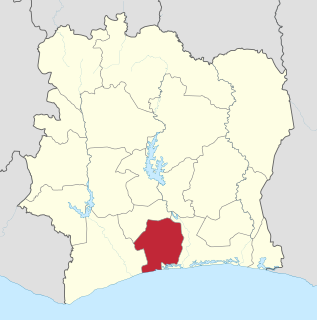
Vallée du Bandama Region Région de la Vallée du Bandama | |||||
Defunct region of Ivory Coast | |||||
| |||||
Location of Vallée du Bandama Region in Ivory Coast | |||||
Capital | Bouaké | ||||
History | |||||
• | Established as a first-level subdivision | 1997 | |||
• | Disestablished | 2011 | |||
Area | 28,518 km2(11,011 sq mi) | ||||
Today part of | Vallée du Bandama District |
Vallée du Bandama Region is a defunct region of Ivory Coast. From 1997 to 2011, it was a first-level subdivision region. The region's capital was Bouaké and its area was 28,518 km². [1] Since 2011, the area formerly encompassed by the region is co-extensive with Vallée du Bandama District. [2]
The regions of Ivory Coast are the second-level subdivisions of Ivory Coast. There are 31 regions, and each region is subdivided into two or more departments, the third-level division in Ivory Coast. Two to four regions are combined to make up a district, the first-level subdivision. The two autonomous districts of Ivory Coast are not divided into regions.
Ivory Coast or Côte d'Ivoire, officially the Republic of Côte d'Ivoire, is a country located on the south coast of West Africa. Ivory Coast's political capital is Yamoussoukro in the centre of the country, while its economic capital and largest city is the port city of Abidjan. It borders Guinea and Liberia to the west, Burkina Faso and Mali to the north, Ghana to the east, and the Gulf of Guinea to the south.
Bouaké is the second-largest city in Ivory Coast, with a population of 536,189. It is the seat of three levels of subdivision—Vallée du Bandama District, Gbêkê Region, and Bouaké Department. The city is located in the central part of Ivory Coast about 50 kilometres (31 mi) northeast of Lake Kossou, the country's largest lake. It is approximately 350 kilometres (220 mi) north of Abidjan on the Abidjan-Niger Railway and about 100 kilometres (62 mi) northeast of Yamoussoukro, the capital of the country.
At the time of its dissolution, Vallée du Bandama Region was divided into five departments: Béoumi, Bouaké, Dabakala, Katiola, and Sakassou.
Departments of Ivory Coast are currently the third-level administrative subdivision of the country. Each of the 31 second-level regions of Ivory Coast is divided into two or more departments. Each department is divided into two or more sub-prefectures, which are the fourth-level subdivisions in Ivory Coast. As of 2016, there are 108 departments of Ivory Coast.
Béoumi Department is a department of Gbêkê Region in Vallée du Bandama District, Ivory Coast. In 2014, its population was 154,206 and its seat is the settlement of Béoumi. The sub-prefectures of the department are Ando-Kékrénou, Béoumi, Bodokro, Kondrobo, Lolobo, Marabadiassa, and N'Guessankro. It is the geographical center of the country.
Bouaké Department is a department of Gbêkê Region in Vallée du Bandama District, Ivory Coast. In 2014, its population was 680,694, making it the most populous department in the country. The seat of the department is the city of Bouaké. The sub-prefectures of the department are Bouaké-SP, Bouaké-Ville, Bounda, Brobo, Mamini, and N'Djébonouan.
Vallée du Bandama Region was abolished as part of the 2011 administrative reorganisation of the subdivisions of Ivory Coast. The area formerly encompassed by the region is now Vallée du Bandama District.
Ivory Coast is a relatively decentralised state. The country divided into 14 districts, of which two are cities organised as autonomous districts. The 12 non-autonomous districts are subdivided into 31 second-level regions. The autonomous districts and the regions are divided into 108 third-level departments. The departments are divided into 510 fourth-level sub-prefectures. Sub-prefectures contain villages and, in some instances, several villages are combined into fifth-level communes. There are 197 communes.
Vallée du Bandama District is one of fourteen administrative districts of Ivory Coast. The district is located in the north-central part of the country. The capital of the district is Bouaké.
Agnéby Region is a defunct region of Ivory Coast. From 1997 to 2011, it was a first-level subdivision region. The region's capital was Agboville and its area was 9,234 km². Since 2011, the area formerly encompassed by the region is part of Lagunes District.
Bas-Sassandra Region is a defunct region of Ivory Coast. From 1997 to 2011, it was a first-level subdivision region. The region's capital was San-Pédro and its area was 26,440 km². Since 2011, the area formerly encompassed by the region is part of Bas-Sassandra District.
Fromager Region is a defunct region of Ivory Coast. From 2000 to 2011, it was a first-level subdivision region. The region's capital was Gagnoa and its area was 6,903 km². Since 2011, the area formerly encompassed by the region is the second-level Gôh Region in Gôh-Djiboua District.
Lacs Region is a defunct region of Ivory Coast. From 1997 to 2011, it was a first-level subdivision region. The region's capital was Yamoussoukro and its area was 8,875 km². Since 2011, the area formerly encompassed by the region is the Autonomous District of Yamoussoukro and part of Lacs District.
N'Zi-Comoé Region is a defunct region of Ivory Coast. From 1997 to 2011, it was a first-level subdivision region. The region's capital was Dimbokro and its area was 19,242 km². Since 2011, the area formerly encompassed by the region is part of Lacs District.
Savanes Region is a defunct region of Ivory Coast. From 1997 to 2011, it was a first-level subdivision region. The region's capital was Korhogo and its area was 40,210 km². Since 2011, the area formerly encompassed by the region is co-extensive with Savanes District.
Sud-Bandama Region is a defunct region of Ivory Coast. From 1997 to 2011, it was a first-level subdivision region. The region's capital was Divo and its area was 10,677 km². Since 2011, the area formerly encompassed by the region is divided between Bas-Sassandra and Gôh-Djiboua Districts.
Sakassou Department is a department of Gbêkê Region in Vallée du Bandama District, Ivory Coast. In 2014, its population was 94,525 and its seat is the settlement of Sakassou. The sub-prefectures of the department are Ayaou-Sran, Dibri-Assirikro, Sakassou, and Toumodi-Sakassou.
Botro Department is a department of Gbêkê Region in Vallée du Bandama District, Ivory Coast. In 2014, its population was 81,424 and its seat is the settlement of Botro. The sub-prefectures of the department are Botro, Diabo, Krofoinsou, and Languibonou.
Dabakala Department is a department of Hambol Region in Vallée du Bandama District, Ivory Coast. In 2014, its population was 189,254 and its seat is the settlement of Dabakala. The sub-prefectures of the department are Bassawa, Boniérédougou, Dabakala, Foumbolo, Niéméné, Satama-Sokoro, Satama-Sokoura, Sokala-Sobara, Tendéné-Bambarasso, and Yaossédougou.
Katiola Department is a department of Hambol Region in Vallée du Bandama District, Ivory Coast. In 2014, its population was 106,905 and its seat is the settlement of Katiola. The sub-prefectures of the department are Fronan, Katiola, and Timbé.
The districts of Ivory Coast are the first-level administrative subdivisions of the country. The districts were created in 2011 in an effort to further decentralise the state, but in practice most of them have not yet begun to function as governmental entities.
Gôh-Djiboua District is one of fourteen administrative districts of Ivory Coast. The district is located in the southwest corner of the country. The capital of the district is Gagnoa.
Gbêkê Region is one of the 31 regions of Ivory Coast. Since its establishment in 2011, it has been one of two regions in Vallée du Bandama District. The seat of the region is Bouaké and the region's population in the 2014 census was 1,010,849, making it the third-most populous region of Ivory Coast.
Niakaramandougou Department is a department of Hambol Region in Vallée du Bandama District, Ivory Coast. In 2014, its population was 133,818 and its seat is the settlement of Niakaramandougou. The sub-prefectures of the department are Arikokaha, Badikaha, Niakaramandougou, Niédiékaha, Tafiré, and Tortiya.
Centre Department was one of the original four departments of Ivory Coast. It was established in 1961, along with Nord Department, Sud-Est Department, and Sud-Ouest Department. During Centre Department's existence, departments were the first-level administrative subdivisions of Ivory Coast.
Coordinates: 8°15′N4°50′W / 8.250°N 4.833°W
A geographic coordinate system is a coordinate system that enables every location on Earth to be specified by a set of numbers, letters or symbols. The coordinates are often chosen such that one of the numbers represents a vertical position and two or three of the numbers represent a horizontal position; alternatively, a geographic position may be expressed in a combined three-dimensional Cartesian vector. A common choice of coordinates is latitude, longitude and elevation. To specify a location on a plane requires a map projection.