
Saint Lucia is an island country in the West Indies in the eastern Caribbean Sea on the boundary with the Atlantic Ocean. The island was previously called Iyonola, the name given to the island by the native Arawaks, and later Hewanorra, the name given by the native Caribs, two separate Amerindian peoples. Part of the Windward Islands of the Lesser Antilles, it is located north/northeast of the island of Saint Vincent, northwest of Barbados and south of Martinique. It covers a land area of 617 km2 and reported a population of 165,595 in the 2010 census. Its capital is Castries. Soufrière was colonized by the French and was the original capital of the island.

Castries, population 20,000, aggl. 53,639, is the capital and largest city of Saint Lucia, an island country in the Caribbean. The district with the same name had a population of 70,000 on 22 May 2013 and stretches over an area of 80 km2 (31 sq mi).

The island nation of Saint Lucia is divided into 10 districts. The name Quarters or Quartiers originally came from the French period in Saint Lucia. The 2001 and 2010 Census of Saint Lucia refers to the first level administrative divisions as districts. The FIPS and ISO standards regularly called these divisions quarters or quartiers in French. The former district of Dauphin Quarter was merged into Gros Islet District and the former district of Praslin Quarter was merged into Micoud District.

The Saint Lucia Football Association is the governing body of football in Saint Lucia. The FA was founded in 1979, the same year the island gained independence, and is headquartered in Castries, the nation's capital. It runs the Saint Lucia men's and women's junior and senior national teams, as well as its domestic football competitions, which include both men's and women's professional leagues and youth championships.

Castries District is one of 10 districts on the Caribbean island nation of Saint Lucia. According to the 2012 census, the population of the district was 80,573, having shown a slow but steady increase over the past ten years. The capital of Saint Lucia, the city of Castries, is located in this district. During the Saint Lucia Jazz Festival, the city of Castries plays host to several stages.
Richard Frederick is a Saint Lucian lawyer and politician, he is the Minister in the Office of the Prime Minister with Responsibility for Housing and Local Government. Fredrick made his debut in the 2021 Saint Lucian General Election, earning his seat for the Castries Central Constituency as an Independent candidate in the House of Assembly. He previously served in parliament from 2006 to 2016, and he was Minister for Physical Planning, Housing, Urban Renewal and Local Government.

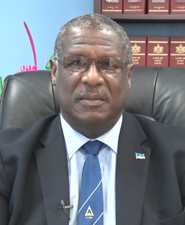
Philip Joseph Pierre is a Saint Lucian politician currently serving as the prime minister of Saint Lucia since 28 July 2021. Pierre serves as the Minister for Finance, Economic Development and the Youth Economy. He is the Leader of the Saint Lucia Labour Party since 18 June 2016. He has represented the Castries East constituency in the House of Assembly since 1997.

Marigot Bay is located on the western coast of the Caribbean island country of Saint Lucia, 3.75 miles southwest from Castries and a short distance from the Saint Lucian National Marine Reserve. It is surrounded on three sides by steep, forested hills.
Stephenson King is the former Prime Minister of Saint Lucia. He is the Senior Minister and Minister for Infrastructure, Ports, Transport, Physical Development, and Urban Renewal. King was the former candidate for the United Workers Party (UWP). He now represents the constituency of Castries North as an Independent candidate as of July 2021 after resigning from the UWP.

Babonneau is one of the regions of the Caribbean island nation of Saint Lucia. Babonneau is located in the north of the island in the Castries Quarter. There are extensive rain forests in the region, which is an important source of fresh water for Saint Lucia. Babonneau is also an electoral constituency of Saint Lucia represented in the House of Assembly of Saint Lucia, which extends into Gros Islet District.

The Roseau Valley in St. Lucia is home to the island's largest banana plantation. The Roseau River runs through the valley and enters the sea at Roseau Bay. It is the longest river in St Lucia and the Roseau Reservoir is a major source of drinking water.

The Castries River is a river in Castries Quarter on the island county of Saint Lucia.

Ti Rocher is a town in the Micoud District of the island nation of Saint Lucia. It is also a 2nd level division in Micoud District.
Trois Pitons is a second-order administrative division and populated place in the Castries District of the island nation of Saint Lucia. it is located at the northern end of the island towards its heart, near Four Roads Junction, Dubrassay, and Ti Rocher.
Barre Denis is a second-order administrative division in Castries District on the island nation of Saint Lucia. It has a population of 699. The town within Barre Denis is called Berre Denis. Barre Densis is located at the northern end of the island towards its heart, between Deglos and Tourat.
Tourat is a town on the island of Saint Lucia; it is located towards the western coast of the island near Barre Denis.
Sarot is a town in the Sarot second-order division of the Castries District of the island nation of Saint Lucia. The Sarot division has a population of 690. Sarot is located towards the heart of the island, between Vanard and Durandeau and close to Morne Ciseaux and La Treille.
Morne Ciseaux is a town in the Anse la Raye District of the island nation of Saint Lucia. There is also a second-order subdivision, Morne Ciseaux, that has a population of 160 in 2010. The town is located towards the heart of the island, between Vanard and La Treille.
Education in St Lucia is compulsory from the ages of 5 to 15 years. Before independence schools in St Lucia were managed by different religious denominations, in particular, the Roman Catholic Church, the Seventh-day Adventist, and Methodist churches. St Lucia has achieved universal primary education, and universal secondary education. School hours in St Lucia are normally from 9 a.m. to 3 p.m., with secondary schools starting at 8 a.m. and ending at 2:30 p.m. There are approximately 73 primary schools in St Lucia, and 23 secondary schools. St Lucia has a number of medical schools and universities. The Sir Arthur Lewis Community College is located in Castries, where most St Lucians go to further their studies. The St Lucia government had begun to provide all Form 4 students on the island with laptops, but stopped in 2016 due to the new UWP guidelines. The literacy rate in St Lucia is estimated to be 90%.
Ti Rocher is a settlement in the Castries District on the island of Saint Lucia. The village is located near the center of the island, near Four Roads Junction, Dubrassay, and Trois Pitons. It is nestled between the peaks of Mount du Chazeau and Gros Morne which separate the basin of Castries from the Valley of the Cul de Sac River.
