Related Research Articles

Vancouver Island is an island in the northeastern Pacific Ocean and part of the Canadian province of British Columbia. The island is 456 km (283 mi) in length, 100 km (62 mi) in width at its widest point, and 32,134 km2 (12,407 sq mi) in area. The island is the largest by area and the most populous along the west coasts of the Americas.

Port Alberni is a city located on Vancouver Island in the province of British Columbia, Canada. The city lies within the Alberni Valley at the head of the Alberni Inlet, Vancouver Island's longest inlet. It is the location of the head offices of the Alberni-Clayoquot Regional District. Port Alberni currently has a total population of 18,259.
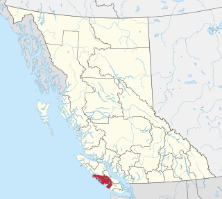
The Alberni–Clayoquot Regional District of British Columbia is located on west central Vancouver Island. Adjacent regional districts it shares borders with are the Strathcona and Comox Valley Regional Districts to the north, and the Nanaimo and Cowichan Valley Regional Districts to the east. The regional district offices are located in Port Alberni.

Qualicum Beach is a town located on Vancouver Island, British Columbia, Canada. In the 2021 census, it had a population of 9,303. It is situated at the foot of Mount Arrowsmith, along the Strait of Georgia on Vancouver Island's northeastern coast.

The Regional District of Nanaimo is a regional district located on the eastern coast of Vancouver Island, British Columbia, Canada. It is bordered to the south by the Cowichan Valley Regional District, to the west by the Alberni-Clayoquot Regional District, and to the northwest by the Comox Valley Regional District. Its administration offices are located in Nanaimo. During the 2016 census, its population was established at 155,698.
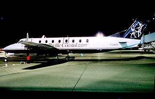
Pacific Coastal Airlines Ltd is a Canadian regional airline that operates scheduled, charter and cargo services to destinations in British Columbia. Its head office is located in the South Terminal of Vancouver International Airport in Richmond, British Columbia. Its main base is Vancouver International Airport, with a hub at Port Hardy Airport.
Island Health, also known as the Vancouver Island Health Authority, is the publicly funded health care provider in the southwestern portion of the Canadian province of British Columbia. It was established as one of five geographically based health authorities in 2001 by the Government of British Columbia.

Scott Kenneth Fraser is a Canadian politician, who represented the Mid Island-Pacific Rim electoral district Legislative Assembly of British Columbia from 2005 to 2020. He is a member of the British Columbia New Democratic Party and was first elected as a Member of the Legislative Assembly in the 2005 election and re-elected in the 2009, 2013 and 2017 elections. During the 41st Parliament (2017-2020) he served in the Executive Council as the Minister of Indigenous Relations and Reconciliation. In that role he led the government through adopting the Declaration on the Rights of Indigenous Peoples Act, with all party support, to implement UNDRIP

The Vancouver Island Ranges, formerly called the Vancouver Island Mountains, are a series of mountain ranges extending along the length of Vancouver Island which has an area of 31,788 km2 (12,273 sq mi). The Vancouver Island Ranges comprise the central and largest part of the island. The Geological Survey of Canada refers to Vancouver Island, Haida Gwaii, and the Alaska Panhandle as the Insular Belt including the sea floor out to 100 km (62 mi) west of Vancouver Island. The Vancouver Island Ranges are a sub-range of the Insular Mountains.
The Insular Mountains are a range of mountains in the Pacific Coast Ranges on the Coast of British Columbia, Canada, comprising the Vancouver Island Ranges and Queen Charlotte Mountains. The Insular Mountains are rugged, particularly on Vancouver Island where peaks in Strathcona Provincial Park rise to elevations of more than 2,000 m (6,562 ft). The highest of these mountains is Golden Hinde on Vancouver Island, which rises to 2,196.818 m (7,207 ft).
The Vancouver Island Regional Library(VIRL) is the fourth-largest library system in British Columbia. It serves more than 430,000 people on Vancouver Island, Haida Gwaii and the Central Coast through 39 branch libraries and a books-by-mail service. Administrative offices are located in Nanaimo. Vancouver Island Regional Library opened its doors in 1936 as the Vancouver Island Union Library; it was the second regional library in North America.

Alberni Valley is a broad valley located at the head of Alberni Inlet on Vancouver Island in British Columbia, Canada. It is home to Port Alberni, Sproat Lake and other outlining areas. The term is largely used as a synonym for Greater Port Alberni and adjoining communities but is used in a larger regional sense as well. Various local organizations and companies use the term "Alberni Valley" in their name, e.g. the Alberni Valley Times and Alberni Valley News newspapers the Alberni Valley Chamber of Commerce and the Alberni Valley Bulldogs minor hockey team. The Canadian pioneer, Joe Drinkwater lived in Alberni Valley during the late nineteenth and early twentieth centuries.
An electoral redistribution was undertaken in 2008 in British Columbia in a process that began in late 2005 and was completed with the passage of the Electoral Districts Act, 2008 on April 10, 2008. The redistribution modified most electoral boundaries in the province and increased the number of MLAs from 79 to 85. The electoral boundaries created by the redistribution were first used in the 2009 provincial election.
An electoral redistribution in British Columbia was undertaken by the BC Electoral Boundaries Commission beginning in 2014 and was formalized by the passage of Bill 42, the 2015 Electoral Districts Act, during the 40th British Columbia Parliament. The act came into effect on November 17, 2015. The redistribution added two seats to the previous total, increasing the number of MLAs in the province from 85 to 87. The electoral boundaries came into effect for the 2017 election. The next redistribution is required to occur following the 2020 British Columbia general election.
References
- ↑ "Sproat Lake". BC Geographical Names .
- 1 2 Walbran, Captain John T. (1971), British Columbia Place Names, Their Origin and History (Facsimile reprint of 1909 ed.), Vancouver/Toronto: Douglas & McIntyre, ISBN 0-88894-143-9, archived from the original on 2016-03-03, retrieved 2014-07-06
- 1 2 3 4 5 Hayman, John, ed. (1989), Robert Brown and the Vancouver Island Exploring Expedition, Vancouver: University of British Columbia Press, ISBN 0-7748-0322-3
- 1 2 3 Mackie, Richard Somerset (1995), The Wilderness Profound, Victorian Life on the Gulf of Georgia , Victoria, BC: Sono Nis Press, ISBN 1-55039-058-9
- ↑ Hayes, Derek (1999), Historical Atlas of British Columbia and the Pacific Northwest, Vancouver: Cavendish Books, p. 165, ISBN 1-55289-900-4