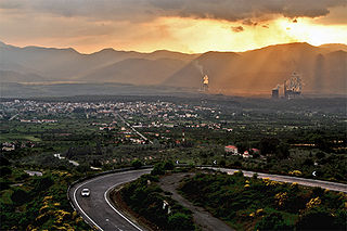
Megalopoli is a town in the southwestern part of the regional unit of Arcadia, southern Greece. It is located in the same site as ancient Megalopolis. When it was founded in 371 BC, it was the first large urbanization in rustic Arcadia. Its theater had a capacity of 20,000 visitors, making it one of the largest ancient Greek theaters.
Souli is a village and a community in the municipality of Megalopoli in southwestern Arcadia, Greece. The community consists of the mountain villages Souli and Derveni. Both villages are located in the mountains on the border with Messenia, at about 500 m elevation. Derveni is on the old road from Megalopoli to Kalamata, and Souli is 1 km southeast of it. Souli is 2 km west of Chirades, 4 km southwest of Paradeisia, 15 km southwest of Megalopoli and 30 km north of Kalamata. Souli suffered damage from the 2007 Greek forest fires.
Tripotamo is a village in the municipality of Megalopoli in the southwestern part of Arcadia, Greece. It is situated on the right bank of the rerouted Alfeios river, near its confluence with two smaller tributaries. It is 3 km southeast of Choremis, 3 km northeast of Neochori Lykosouras, 4 km northwest of Veligosti and 5 km southwest of Megalopoli. There is a large open-pit lignite mine to the northeast.
Makrysi is a village and a community in the municipality of Megalopoli, Arcadia, Greece. It is situated on a hillside on the left bank of the river Elissonas, at 496 m elevation. It is 3 km northwest of Mallota and 3 km northeast of Megalopoli town centre. The community consists of the villages Makrysi and Kato Makrysi. Kato Makrysi is situated at 450 m elevation. Zacharias Barbitsiotis, an anti-Ottoman insurgent defeated the Turks in Sialesi in the 1780s.
Rapsommati is a village within the municipality of Megalopoli in the western part of Arcadia, Greece. It is situated on a hill, 1 km southeast of Mallota, 2 km southwest of Palaiochouni, 3 km northwest of Anemodouri and 5 km southeast of Megalopoli. The Moreas Motorway passes north of the village, through the Rapsommati Tunnel.

Gortyna, is a former municipality in Arcadia, Peloponnese, Greece. Since the 2011 local government reform it is part of the municipality Megalopoli, of which it is a municipal unit. The municipal unit has an area of 116.205 km2. Its seat was in the village Karytaina. The name of the municipality was taken from the ancient city of Gortys.

Isaris is a village and a community in the municipality of Megalopoli, Arcadia, Greece. It is situated in the mountains west of the Alfeios valley, at about 750 m elevation. It is considered a traditional settlement. It is 2 km east of Vastas, 5 km northwest of Chranoi and 11 km southwest of Megalopoli. The community includes the small villages Petrovouni and Chrousa.
Paradeisia is a village and a community in Arcadia, Greece, and a part of the municipality of Megalopoli. The community consists of the villages Paradeisia and Fanaiti. Paradeisia is 4 km east of Chranoi, 4 km west of Veligosti, 4 km north of Chirades and 11 km southwest of Megalopoli.
Plaka is a village in the municipality of Megalopoli, Arcadia, Greece. It is 1 km south of Soulos, 3 km northeast of Thoknia, 3 km southwest of Nea Ekklisoula and 4 km northwest of Megalopoli. The Greek National Road 76 passes east of the village. The Megalopoli Power Plant is located to the south and a large open-pit lignite mine is to the west.
Soulos is a village in the municipality of Megalopoli, Arcadia, Greece. It is situated on a hillside, 1 km north of Plaka, 2 km southeast of Katsimpalis, 2 km west of Nea Ekklisoula and 5 km northwest of Megalopoli. The Greek National Road 76 passes east of the village.
Thoknia is a village in the municipality of Megalopoli, Arcadia, Greece. It is situated near the confluence of the rivers Alfeios and Elissonas, at about 360 m elevation. It was named after the ancient Arcadian city Thocnia, that was located in the area. Thoknia is 2 km east of Kato Karyes, 3 km southeast of Kyparissia, 3 km southwest of Plaka and 5 km northwest of Megalopoli. The village is surrounded by open-pit lignite mines.
Nea Ekklisoula is a village in the municipality of Megalopoli, Arcadia, Greece. It is situated near the southwestern foothills of the Mainalo mountains, at about 450 m elevation. It is 2 km southwest of Trilofo, 2 km east of Soulos and 4 km north of Megalopoli town centre.
Trilofo is a village and a community in the municipality of Megalopoli, Arcadia, Greece. It is situated in the southwestern foothills of the Mainalo mountains, at about 550 m elevation. It is 2 km northeast of Nea Ekklisoula, 3 km southeast of Zoni, 3 km southwest of Karatoulas and 6 km north of Megalopoli. The community includes the village Palaiomoiri.
Karatoulas is a village in the municipality of Megalopoli, Arcadia, Greece. It is situated on a hillside in the southwestern foothills of the Mainalo mountains, at about 750 m elevation. It is 2 km northwest of Vangos, 3 km southeast of Lykochia and 9 km northeast of Megalopoli.
Palaiochouni is a village in the municipal unit Valtetsi, Arcadia, Greece. It is situated in the hills on the eastern end of the plain of Megalopoli, at 700 m elevation. It is 2 km east of Mallota, 3 km west of Athinaio, 7 km east of Megalopoli and 19 km southwest of Tripoli. The Greek National Road 7 passes through the village.
Neochori Lykosouras is a village in the municipality of Megalopoli, Arcadia, Greece. It is situated on a hillside overlooking the Alfeios river valley, at about 490 m elevation. It is 3 km north of Paradeisia, 3 km southwest of Tripotamo, 5 km southeast of Isaris and 8 km southwest of Megalopoli.
Kastanochori is a village in the municipality of Megalopoli, Arcadia, Greece. It is situated in the southeastern foothills of mount Lykaion, at about 750 m elevation. It is 2 km east of Lykaio, 3 km southwest of Isoma Karyon and 10 km west of Megalopoli.
Katsimpalis is a village in the municipal unit of Gortyna, southwest Arcadia, Greece. It is situated on a hillside above the right bank of the river Alfeios. It is 2 km southwest of Zoni, 3 km east of Kyparissia, 6 km southeast of Karytaina and 7 km northwest of Megalopoli. There is a large lignite mine to the south. The Greek National Road 76 passes through the village.
Lykochia is a village in the municipality of Megalopoli, Arcadia, Greece. It is situated in the southwestern foothills of the Mainalo mountains. It is 2 km northeast of Pavlia, 3 km northwest of Karatoulas, 7 km southwest of Chrysovitsi and 11 km north of Megalopoli.
Dyrrachio is a mountain village in the municipal unit of Falaisia, southwestern Arcadia, Greece. It is considered a traditional settlement and is situated at an altitude of 800 metres (2,600 ft) in the Taygetos mountains of the Peloponnese. It is 3 km west of Neochori, 4 km east of Akovos, 7 km southwest of Longanikos and 25 km south of Megalopoli. Dyrrachio suffered damage from the 2007 Greek forest fires.
