The Sko or Skou languages are a small language family spoken by about 7000 people, mainly along the Vanimo coast of Sandaun Province in Papua New Guinea, with a few being inland from this area and at least one just across the border in the Indonesian province of Papua.

Sandaun Province is the northwesternmost province of Papua New Guinea. It covers an area of 35,920 km2 and has a population of 248,411. The capital is Vanimo. In July 1998 the area surrounding the town Aitape was hit by an enormous tsunami caused by a Magnitude 7.0 earthquake which killed over 2,000 people. The five villages along the west coast of Vanimo towards the International Border are namely; Lido, Waromo, Yako, Musu and Wutung.

Wewak is the capital of the East Sepik province of Papua New Guinea. It is located on the northern coast of the island of New Guinea. It is the largest town between Madang and Jayapura. It is the see city (seat) of the Roman Catholic Diocese of Wewak.

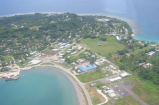
Vanimo is the capital of Sandaun Province in north-westernmost Papua New Guinea and of Vanimo-Green River District. It is located on a peninsula close to the border with Indonesia.
Waris or Walsa is a Papuan language of northern New Guinea.
Amanab is a Papuan language spoken by 4,400 people in Amanab District, Sandaun Province, Papua New Guinea.

The Roman Catholic Diocese of Vanimo is a suffragan diocese in the Latin rite ecclesiastical province of the Metropolitan Archdiocese of Madang in Papua New Guinea, yet depends on the Roman Congregation for the Evangelization of Peoples.

The 1998 Papua New Guinea earthquake occurred on July 17 with a moment magnitude of 7.0 and a maximum Mercalli intensity of VIII (Severe). The event occurred on a reverse fault near the north coast region of Papua New Guinea, 25 kilometers (16 mi) from the coast near Aitape, and caused a large undersea landslide which caused a tsunami that hit the coast, killing between at least 2,183 and 2,700 people and injuring thousands.

This page is a list of districts of Papua New Guinea.

Kainantu District is a district of the Eastern Highlands Province in Papua New Guinea. Its capital is Kainantu.
May River Iwam, often simply referred to as Iwam, is a language of East Sepik Province, Papua New Guinea.

Indonesia – Papua New Guinea relations are foreign relations between Indonesia and Papua New Guinea, two bordering countries north of Australia.

Aitape-Lumi District is a district of Sandaun Province of Papua New Guinea. Its capital is Aitape. The provincial administration is called the Sandaun Provincial Administration. The provincial capital is Vanimo, about 200 km up the northwest coastline.
DeraAKAMangguar and Kamberataro (Komberatoro) is a Senagi language of Papua New Guinea and Indonesia. In Papua New Guinea, it is primarily spoken in Kamberataro village, Amanab Rural LLG, Sandaun Province.
Pagi, or Bembi, is a Papuan language spoken by 2,000 people in five villages in Sandaun Province and in Vanimo District of Papua New Guinea, near the border with Indonesian Papua.
Vanimo is a Skou language of Papua New Guinea which extends from Leitre to Wutung on the Papua New Guinea - Indonesian border.
Angor (Anggor) AKASenagi is a Senagi language of northern Papua New Guinea. It is spoken in 11 villages of Amanab Rural LLG, Sandaun Province, including Senagi village of Bibriari ward.
Rawo is a Papuan language in the Skou family, spoken on the north coast of Papua New Guinea in the vicinity of the village of Leitre (Laitre) in Bewani-Wutung Onei Rural LLG, Sandaun Province.
Vanimo Rural LLG is a local-level government (LLG) of Sandaun Province, Papua New Guinea.

The Indonesia-Papua New Guinea border is the international border between Indonesia and Papua New Guinea. The border, which divides the island of New Guinea in half, consists of two straight north–south lines connected by a short section running along the Fly river, totalling 824 km.


