
Będzin is a city in the Dąbrowa Basin, in southern Poland. It lies in the Silesian Highlands, on the Czarna Przemsza River. Even though part of Silesian Voivodeship, Będzin belongs to historic Lesser Poland, and it is one of the oldest towns of this region. Będzin is regarded as the capital of industrial Dąbrowa Basin.

Tykocin is a small town in north-eastern Poland, with 2,010 inhabitants (2012), located on the Narew river, in Białystok County in the Podlaskie Voivodeship. It is one of the oldest towns in the region, with its historic center designated a Historic Monument of Poland.
Grajewo is a town in north-eastern Poland with 21,499 inhabitants (2016). It is the capital of Grajewo County within the Podlaskie Voivodeship. It is located within the historic region of Masovia, near the border with Podlachia and Masuria.

Aukštieji Paneriai is a neighborhood of Vilnius, situated about 10 kilometres away from the city center. It is located on low forested hills, on the Vilnius-Warsaw road. Paneriai was the site of the Ponary massacre, a mass killing of as many as 100,000 people from Vilnius and nearby towns and villages during World War II.

Vištytis is a small town in Marijampolė County, Vilkaviškis District Municipality in southwestern Lithuania on the border with Russia and close to the border with Poland. It is the administrative center of Vištytis eldership (seniūnija).
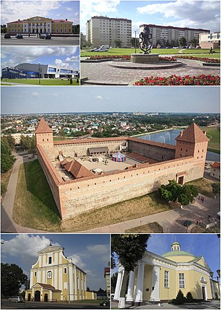
Lida is a city in Grodno Region, western Belarus, located 168 kilometres (104 mi) west of Minsk. It serves as the administrative center of Lida District. As of 2024, it has a population of 103,916.

Przysucha is a town in south-central Poland. Located in historic Lesser Poland, it is part of the Masovian Voivodeship, about 100 km southwest of Warsaw and 40 km west of Radom. It is the capital of Przysucha County, and the town 6,762 inhabitants (2004). Its name in Yiddish is פּשיסכע or פשיסחא or פשיסכא. In the past, it was home to a number of Hasidic Rabbis, such as The Holy Jew and Simcha Bunim of Peshischa.

Szydłów is a fortified town in Staszów County, Świętokrzyskie Voivodeship, in southeastern Poland. It is the seat of the gmina called Gmina Szydłów. It lies approximately 13 kilometres (8 mi) west of Staszów and 43 km (27 mi) south-east of the regional capital Kielce.

Rymanów is a town located in the Subcarpathian Voivodeship, in the southeastern tip of Poland, with 3,585 inhabitants. It is a capital of a separate commune within Krosno County. Rymanów is situated in the heartland of the Doły (Pits) valley, and its average altitude is 420 metres (1,377.95 ft) above sea level, although there are some hills located within the confines of the town.
Lipsko is a town in eastern Poland, in northern Lesser Poland, Masovian Voivodeship. It is the capital of Lipsko County. The population is 5,895 (2004). Lipsko’s coat of arms is the Dębno, which was used by previous owners of the town.
Miechów is a town in Poland, in Lesser Poland Voivodeship, about 40 kilometres north of Kraków. It is the capital of Miechów County. Population is 11,852 (2004). Miechów lies on the Miechówka river, along European route E77. The area of the town is 15 square kilometres (6 sq mi), and it has a rail station, located on the main railroad which connects Kraków with Warsaw.
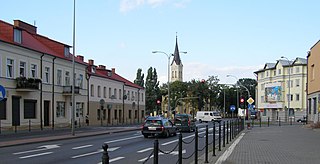
Nasielsk is a small town in Masovian Voivodeship, Poland. It is located approximately 50 kilometres (31 mi) north of the Polish capital Warsaw, on the Warsaw-Gdańsk rail line and serves as a railway junction. In 2020, the population of the town was estimated at 7,650 residents.

Hlybokaye or Glubokoye is a town in Vitebsk Region, Belarus. It serves as the administrative center of Hlybokaye District. As of 2024, it has a population of 17,746.

The Ponary massacre, or the Paneriai massacre, was the mass murder of up to 100,000 people, mostly Jews, Poles, and Russians, by German SD and SS and the Lithuanian Ypatingasis būrys killing squads, during World War II and the Holocaust in the Generalbezirk Litauen of Reichskommissariat Ostland. The murders took place between July 1941 and August 1944 near the railway station at Ponary, a suburb of today's Vilnius, Lithuania. 70,000 Jews were murdered at Ponary, along with up to 2,000 Poles, 8,000 Soviet POWs, most of them from nearby Vilnius, and its newly formed Vilna Ghetto.

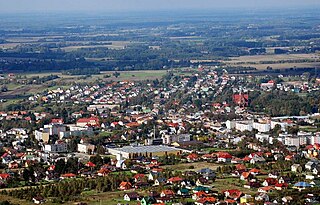
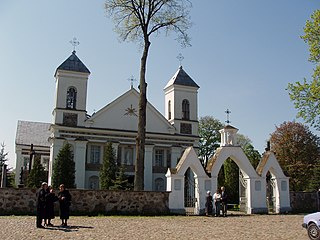
Daleszyce is a town in Kielce County, Świętokrzyskie Voivodeship, Poland, with 2,830 inhabitants as of December 2021. It became a town at the start of 2007. Daleszyce lies among the hills of the Malopolska Upland, in the historic province of Lesser Poland. The area of the town is 15,50 km2, and due to proximity to Kielce, it is served by buses of Kielce Transit System. Origins of its name are not known, Daleszyce was probably named after its founder, a man named Dalesz or Dalech.

Vishnyeva is an agrotown in the Valozhyn District of Minsk Region, Belarus, near the border with Lithuania.
The Suwałki Agreement, Treaty of Suvalkai, or Suwalki Treaty was an agreement signed in the town of Suwałki between Poland and Lithuania on October 7, 1920. It was registered in the League of Nations Treaty Series on January 19, 1922.
Valkininkai is a historic town in Valkininkų (Valkininkai) eldership, Varėna District Municipality, Alytus County, Lithuania, located about 22 km (14 mi) northeast from Varėna and about 55 km (34 mi) southwest from Vilnius. At the Lithuanian census of 2001, its population was 238 and at the census of 2011 it was 229.


