Finnmark is a county in the northern part of Norway.

Vardø is a municipality in Finnmark county in the extreme northeastern part of Norway. Vardø is the easternmost town in Norway, more to the east than Saint Petersburg or Istanbul. The administrative centre of the municipality is the town of Vardø. Two of the larger villages in the municipality are Kiberg and Svartnes.

North Cape is a cape on the northern coast of the island of Magerøya in Northern Norway. The cape is in Nordkapp Municipality in Finnmark county, Norway. The European route E69 motorway (highway) has its northern terminus at North Cape, which makes it the northernmost point in Europe that can be accessed by car and makes the E69 the northernmost public road in Europe. The plateau is a popular tourist attraction. The cape includes a 307-metre-high cliff (1,007 ft) with a large flat plateau on top, where visitors, weather permitting, can watch the midnight sun and views of the Barents Sea to the north. North Cape Hall, a visitor centre, was built in 1988 on the plateau. It includes a café, restaurant, post office, souvenir shop, a small museum, and video cinema.

Hinnøya (Norwegian) or Iinnasuolu (Northern Sami) is the fourth-largest island in Norway, and the largest outside the Svalbard archipelago. The 2,204.7-square-kilometre (851.2 sq mi) lies just off the western coast of Northern Norway. The island sits on the border of Nordland and Troms counties. The western part of the island is in the district of Vesterålen, the southwestern part is in the Lofoten district, the southeastern part is in the Ofoten district, and the northeastern part is in Troms. As of 2017, Hinnøya had a population of 32,688. The only town on the island is the town of Harstad. Some of the larger villages include Borkenes, Lødingen, Sigerfjord, and Sørvik. The island is split between several municipalities: Harstad, Tjeldsund and Kvæfjord in Troms county, as well as Andøy, Hadsel, Lødingen, Sortland, and Vågan in Nordland county.
The Muscovy Company was an English trading company chartered in 1555. It was the first major chartered joint-stock company, the precursor of the type of business that would soon flourish in England and finance its exploration of the world. The Muscovy Company had a monopoly on trade between England and Russia until 1698 and it survived as a trading company until the Russian Revolution. Since 1917, the company has operated as a charity, now working within Russia.
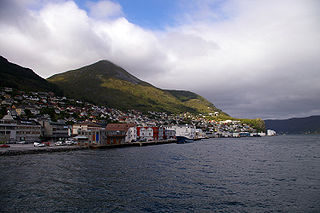
Måløy is a town in the municipality of Kinn in Vestland county, Norway. Måløy is located on the southeastern side of the island of Vågsøy, about 3 kilometres (1.9 mi) northeast of the village of Holvika and about 6 kilometres (3.7 mi) south of the village of Raudeberg. The Måløy Bridge connects the town centre to the area of Deknepollen on the mainland. Sør-Vågsøy Church is located in Måløy.

Richard Chancellor was an English explorer and navigator; the first to penetrate to the White Sea and establish relations with the Tsardom of Russia.

Sir Hugh Willoughby was an English soldier and an early Arctic voyager. He served in the court of Henry VIII and fought in the Scottish campaign where he was knighted for his valour. In 1553, he was selected by a company of London merchants to lead a fleet of three vessels in search of a Northeast Passage.
The Company of Merchant Adventurers to New Lands was an early joint stock association, which began with private exploration and enterprise, and was to have been incorporated by King Edward VI in 1553, but received its full royal charter in 1555. It led to the commencement of English trade with Russia, Persia and elsewhere, and became known informally, and later formally, as the Muscovy Company.

North Cape Tunnel is one of the longest and the northernmost of the subsea road tunnels in Norway. It is located in Nordkapp Municipality in Finnmark county in the far northern part of Norway. The tunnel takes the European route E69 highway under the Magerøysundet strait between the Norwegian mainland and the large island of Magerøya. The tunnel was built between 1993 and 1999, along with the Honningsvåg Tunnel. The tunnels were built to connect the mainland of Norway with the town of Honningsvåg and the tourist attraction at the North Cape. The tunnel was officially opened on 15 June 1999 by King Harald V of Norway. The tunnel is 6.875 kilometres (4.272 mi) long and reaches a depth of 212 metres (696 ft) below sea level. Before the tunnel was built, a ferry carried the traffic across the sea between the village of Kåfjord and the town of Honningsvåg.

Kibergsneset is a peninsula in Vardø Municipality in Finnmark county, Norway. The small peninsula is located on the larger Varanger Peninsula along the Barents Sea. The village of Kiberg sits on the southwestern shore of the peninsula and the town of Vardø is located about 10 kilometres (6.2 mi) to the northeast.
Svartnes is a small village and port in Vardø Municipality, Finnmark county, Norway. It is located on the mainland of the Varanger Peninsula across the Bussesundet strait from the island of Vardøya where the town of Vardø is located. Svartnes has a large harbor and port, protected by a large breakwater. The Vardø Airport, Svartnes is also located here. The European route E75 highway runs through Svartnes, just before entering the Vardø Tunnel which goes under the strait and connects to the town of Vardø. The village of Kiberg lies about 10 kilometres (6.2 mi) to the south. The mountain Domen lies just south of Svartnes.

Aspøya is an artificial island in Tingvoll Municipality in Møre og Romsdal county, Norway. It is located between the Freifjorden and the Tingvollfjorden. The European route E39 highway crosses Aspøya and connects it to the nearby island of Bergsøya to the west by the Bergsøysund Bridge–part of the Krifast bridge and tunnel system which connects the town of Kristansund to the mainland. To the east, the E39 highway connects it to the Straumsnes peninsula in Tingvoll.

Bømlo is an island in Vestland county, Norway. At 171 square kilometres (66 sq mi), it is the largest island in the island municipality of Bømlo, lying just off the western coast of Norway. The island sits at the northern entrance to the vast Hardangerfjorden, west of the Stokksundet strait, south of the Selbjørnsfjorden, and east of the North Sea. In the 1800s, the Kulleseid Canal was built across a small isthmus in the central part of the island, giving a shortcut from the eastern side of the island to the western side of the island.

Ekkerøya (Norwegian), Ihkkot (Northern Sami), or Ekrea (Kven) is one of the oldest fishing villages on the Varangerfjorden in Finnmark county, Norway. It is located in Vadsø Municipality about 15 kilometres (9.3 mi) east of the town of Vadsø which is the administrative centre of the municipality and the county. The village of Valen lies just north of Ekkerøy. The village is known as Ekkerøya in Norwegian, but it can also be called Ekkerøy. The (former) island on which it is located is known as Store Ekkerøya.

Andørja (Norwegian) or Áttir (Northern Sami) is an island in Ibestad Municipality in Troms county, Norway. The 135-square-kilometre (52 sq mi) island lies about 25 kilometres (16 mi) east of the town of Harstad. The island is located entirely within Ibestad Municipality, although the island itself was a separate municipality from 1926 until 1964. The largest population area on Andørja island is the Å - Ånstad - Laupstad area on the west coast with 205 residents (2001). Andørja Church is located in Engenes on the northwestern tip of the island.
Bru is an island in Stavanger municipality in Rogaland county, Norway. The 3-square-kilometre (1.2 sq mi) island lies south of the Boknafjorden, just off the coast of the Stavanger Peninsula, along the Byfjorden. The highest point on the island is the 92-metre (302 ft) tall mountain, Brufjellet. The island sits in a group of islands with Sokn and Mosterøy to the north and Åmøy to the east.
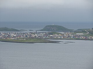
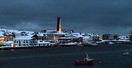
Vardø, Várggát (Northern Sami), or Vuorea (Kven) is a town and the administrative centre of Vardø Municipality in Finnmark county, Norway. The town is located on the island of Vardøya in the Barents Sea, just off the coast of the large Varanger Peninsula. The 1.2-square-kilometre (300-acre) town has a population (2023) of 1,727 which gives the town a population density of 1,439 inhabitants per square kilometre (3,730/sq mi).

Vardø Chapel or Steglnes Chapel is a chapel of the Church of Norway in Vardø Municipality in Finnmark county, Norway. It is located on the western part of the island of Vardøya in the town of Vardø, just south of the historic Vardøhus Fortress. It is an annex chapel for the Vardø parish which is part of the Varanger prosti (deanery) in the Diocese of Nord-Hålogaland.

Hundvåg is an island in Stavanger municipality in Rogaland county, Norway. The island is located in the borough of Hundvåg, just north of the centre of the city of Stavanger, separated by the Byfjorden. The 4.7-square-kilometre (1.8 sq mi) island is relatively flat and very urbanized. There were 9803 residents of the island in 2014. There are some agricultural areas as well as a lot of industry. The small island of Buøy is connected to the south side of Hundvåg by a small man-made isthmus. Hundvåg Church is located on the island.