
A fertilizer or fertiliser is any material of natural or synthetic origin that is applied to soil or to plant tissues to supply plant nutrients. Fertilizers may be distinct from liming materials or other non-nutrient soil amendments. Many sources of fertilizer exist, both natural and industrially produced. For most modern agricultural practices, fertilization focuses on three main macro nutrients: nitrogen (N), phosphorus (P), and potassium (K) with occasional addition of supplements like rock flour for micronutrients. Farmers apply these fertilizers in a variety of ways: through dry or pelletized or liquid application processes, using large agricultural equipment or hand-tool methods.

Precision agriculture (PA) is a farming management strategy based on observing, measuring and responding to temporal and spatial variability to improve agricultural production sustainability. It is used in both crop and livestock production. Precision agriculture often employs technologies to automate agricultural operations, improving their diagnosis, decision-making or performing. First conceptual work on PA and practical applications go back in the late 1980s. The goal of precision agriculture research is to define a decision support system (DSS) for whole farm management with the goal of optimizing returns on inputs while preserving resources.
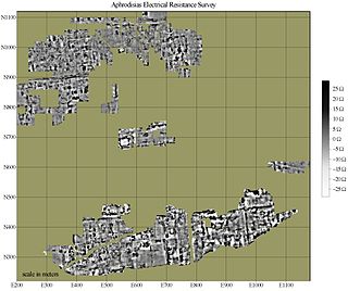
In archaeology, geophysical survey is ground-based physical sensing techniques used for archaeological imaging or mapping. Remote sensing and marine surveys are also used in archaeology, but are generally considered separate disciplines. Other terms, such as "geophysical prospection" and "archaeological geophysics" are generally synonymous.
Soil test may refer to one or more of a wide variety of soil analysis conducted for one of several possible reasons. Possibly the most widely conducted soil tests are those done to estimate the plant-available concentrations of plant nutrients, in order to determine fertilizer recommendations in agriculture. Other soil tests may be done for engineering (geotechnical), geochemical or ecological investigations.

Nutrient management is the science and practice directed to link soil, crop, weather, and hydrologic factors with cultural, irrigation, and soil and water conservation practices to achieve optimal nutrient use efficiency, crop yields, crop quality, and economic returns, while reducing off-site transport of nutrients (fertilizer) that may impact the environment. It involves matching a specific field soil, climate, and crop management conditions to rate, source, timing, and place of nutrient application.

An agrochemical or agrichemical, a contraction of agricultural chemical, is a chemical product used in industrial agriculture. Agrichemical refers to biocides and synthetic fertilizers. It may also include hormones and other chemical growth agents.

Agricultural wastewater treatment is a farm management agenda for controlling pollution from confined animal operations and from surface runoff that may be contaminated by chemicals in fertilizer, pesticides, animal slurry, crop residues or irrigation water. Agricultural wastewater treatment is required for continuous confined animal operations like milk and egg production. It may be performed in plants using mechanized treatment units similar to those used for industrial wastewater. Where land is available for ponds, settling basins and facultative lagoons may have lower operational costs for seasonal use conditions from breeding or harvest cycles. Animal slurries are usually treated by containment in anaerobic lagoons before disposal by spray or trickle application to grassland. Constructed wetlands are sometimes used to facilitate treatment of animal wastes.
An engine test stand is a facility used to develop, characterize and test engines. The facility, often offered as a product to automotive OEMs, allows engine operation in different operating regimes and offers measurement of several physical variables associated with the engine operation.
Strip-till is a conservation system that uses a minimum tillage. It combines the soil drying and warming benefits of conventional tillage with the soil-protecting advantages of no-till by disturbing only the portion of the soil that is to contain the seed row. This type of tillage is performed with special equipment and can require the farmer to make multiple trips, depending on the strip-till implement used, and field conditions. Each row that has been strip-tilled is usually about eight to ten inches wide.

Pesticide application refers to the practical way in which pesticides are delivered to their biological targets. Public concern about the use of pesticides has highlighted the need to make this process as efficient as possible, in order to minimise their release into the environment and human exposure. The practice of pest management by the rational application of pesticides is supremely multi-disciplinary, combining many aspects of biology and chemistry with: agronomy, engineering, meteorology, socio-economics and public health, together with newer disciplines such as biotechnology and information science.
Precision viticulture is precision farming applied to optimize vineyard performance, in particular maximizing grape yield and quality while minimizing environmental impacts and risk. This is accomplished by measuring local variation in factors that influence grape yield and quality and applying appropriate viticulture management practices. Precision viticulture is based on the premise that high in-field variability for factors that affect vine growth and grape ripening warrants intensive management customized according to local conditions. Precision viticulture depends on new and emerging technologies such as global positioning systems (GPS), meteorologic and other environmental sensors, satellite and airborne remote sensing, and geographic information systems (GIS) to assess and respond to variability.

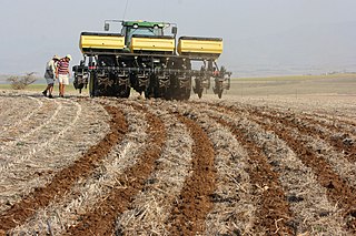
Agricultural machinery relates to the mechanical structures and devices used in farming or other agriculture. There are many types of such equipment, from hand tools and power tools to tractors and the countless kinds of farm implements that they tow or operate. Diverse arrays of equipment are used in both organic and nonorganic farming. Especially since the advent of mechanised agriculture, agricultural machinery is an indispensable part of how the world is fed. Agricultural machinery can be regarded as part of wider agricultural automation technologies, which includes the more advanced digital equipment and robotics. While agricultural robots have the potential to automate the three key steps involved in any agricultural operation, conventional motorized machinery is used principally to automate only the performing step where diagnosis and decision-making are conducted by humans based on observations and experience.
The combine grain yield monitor is a device coupled with other sensors to calculate and record the crop yield or grain yield as a modern-day combine harvester operates. Yield monitors are a part of the precision agriculture products available to producers today that provide producers with the tools to reduce costs, increase yields, and increase efficiency. The present day grain yield monitor is designed to measure the harvested grain mass flow, moisture content, and speed to determine total grain harvested. In most cases today this is coupled with global positioning system to record yield and other spatially variable information across a field. This allows for the creation of a grain yield map which provides information on spatial variability and supports management decisions for producers.
Phytogeomorphology is the study of how terrain features affect plant growth. It was the subject of a treatise by Howard and Mitchell in 1985, who were considering the growth and varietal temporal and spatial variability found in forests, but recognized that their work also had application to farming, and the relatively new science of precision agriculture. The premise of Howard and Mitchell is that landforms, or features of the land's 3D topography significantly affect how and where plants grow. Since that time, the ability to map and classify landform shapes and features has increased greatly. The advent of GPS has made it possible to map almost any variable one might wish to measure. Thus, a very increased awareness of the spatial variability of the environment that plants grow in has arisen. The development of technology like airborne LiDAR has enabled the detailed measurement of landform features to better than sub-meter, and when combined with RTK-GPS enables the creation of very accurate maps of where these features are. Comparison of these landform maps with mapping of variables related to crop or plant growth show a strong correlation.
Yield mapping or yield monitoring is a technique in agriculture of using GPS data to analyze variables such as crop yield and moisture content in a given field. It was developed in the 1990s and uses a combination of GPS technology and physical sensors, such as speedometers, to track crop yields, grain elevator speed, and combine speed.

The Central Institute of Agricultural Engineering (CIAE) is a higher seat of learning, research and development in the field of agricultural engineering, situated in the lake city of Bhopal, Madhya Pradesh, India. It is an autonomous body, an Indian Council of Agricultural Research subsidiary, under the Ministry of Agriculture & Farmer's Welfare, Government of India.

The Indian Institute of Soil Science is an autonomous institute for higher learning, established under the umbrella of Indian Council of Agricultural Research (ICAR) by the Ministry of Agriculture, Government of India for advanced research in the field of soil sciences.
Agricultural technology or agrotechnology is the use of technology in agriculture, horticulture, and aquaculture with the aim of improving yield, efficiency, and profitability. Agricultural technology can be products, services or applications derived from agriculture that improve various input/output processes.
Digital agriculture, sometimes known as smart farming or e-agriculture, is tools that digitally collect, store, analyze, and share electronic data and/or information in agriculture. The Food and Agriculture Organization of the United Nations has described the digitalization process of agriculture as the digital agricultural revolution. Other definitions, such as those from the United Nations Project Breakthrough, Cornell University, and Purdue University, also emphasize the role of digital technology in the optimization of food systems.
This glossary of agriculture is a list of definitions of terms and concepts used in agriculture, its sub-disciplines, and related fields. For other glossaries relevant to agricultural science, see Glossary of biology, Glossary of ecology, Glossary of environmental science, and Glossary of botanical terms.
