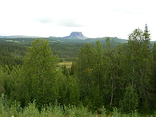
Røssvatnet (Norwegian) or Reevhtse (Southern Sami) is a lake and reservoir in the municipalities of Hattfjelldal and Hemnes in Nordland county, Norway. It has been the site of human occupation since the Stone Age. Its area of 219 square kilometres (85 sq mi) makes it the second largest lake in Norway by surface area. Without the dam which has regulated the lake since 1957, it would be 190 square kilometres (73 sq mi) and the third largest lake in Norway. Its depth is 240 metres (790 ft), its volume is estimated at about 15 cubic kilometres (3.6 cu mi), and its surface elevation is 374 metres (1,227 ft) above sea level.
Arstaddalsdammen is a lake that lies in the municipality of Beiarn in Nordland county, Norway. It is located about 15 kilometres (9.3 mi) southwest of the village of Moldjord. The 2.54-square-kilometre (0.98 sq mi) lake lies in the southern end of the Arstaddal valley, and it has a dam on the northern end. The dam was built in the 1960s. The water from the lake is piped to the nearby lake Sokumvatnet in Gildeskål Municipality. The lake serves as a reservoir for the Sundsfjord Hydroelectric Power Station.

Baugevatnet is a lake that lies in Tysfjord Municipality in Nordland county, Norway. The 4.99-square-kilometre (1.93 sq mi) lake is located about 25 kilometres (16 mi) east of the village of Kjøpsvik and just 1.5 kilometres (0.93 mi) northwest of the border with Sweden. The lake Båvrojávrre lies about 3 kilometres (1.9 mi) to the southwest and the lake Langvatnet lies about the same distance to the north.
Daningen (Norwegian) or Daarenege (Southern Sami) is a lake in the municipality of Hattfjelldal in Nordland county, Norway. The lake lies about 2 kilometres (1.2 mi) west of the border with Sweden and about 4 kilometres (2.5 mi) northeast of the river Vefsna.
Elsvatnet (Norwegian) or Aalesjaevrie (Southern Sami) is a lake in the municipality of Hattfjelldal in Nordland county, Norway. It lies about 6 kilometres (3.7 mi) east of the village of Hattfjelldal, about half-way between the lakes Røssvatnet and Unkervatnet.
Famnvatnet or Famvatnet (Norwegian) or Faepmiejaevrie (Southern Sami) is a lake in the municipality of Hattfjelldal in Nordland county, Norway. The lake is located about 7 kilometres (4.3 mi) east of Røssvatnet and about 7.5 kilometres (4.7 mi) west of the border with Sweden. The nearby lake Krutvatnet lies about 9 kilometres (5.6 mi) to the south.

Jengelvatnet (Norwegian) or Giengelvihke (Southern Sami) is a lake in Norway that lies on the borders of the municipalities of Røyrvik and Grane and Hattfjelldal. The 2.54-square-kilometre (0.98 sq mi) lake lies inside Børgefjell National Park and it drains to the south into the lake Namsvatnet.
Kjerringvatnet (Norwegian) or Aahkanjaevrie (Southern Sami) is a lake in the municipality of Hattfjelldal in Nordland county, Norway. The lake lies about 2 kilometres (1.2 mi) west of the lake Røssvatnet.
Tjårdavatnet or Kjårdavatnet (Norwegian) or Čoađgejávri (Northern Sami) is a lake that is located on the border of Norway and Sweden, about 15 kilometres (9.3 mi) south of the village of Elvegård in Norway. The Norwegian side lies in Narvik Municipality in Nordland county and the Swedish side lies in Gällivare Municipality in Norrbotten County. The lake has an area of about 3.63 square kilometres (1.40 sq mi), with 3.5 square kilometres (1.4 sq mi) being in Norway, the tiny remainder is in Sweden.

Krutvatnet (Norwegian) or Kruvhtegenjaevrie (Southern Sami) is a lake in the municipality of Hattfjelldal in Nordland county, Norway. It lies about 7.5 kilometres (4.7 mi) east of the lake Røssvatnet and about 2 kilometres (1.2 mi) west of the border with Sweden. The Norwegian National Road 73 runs on the southern shore of the lake on its way from the village of Hattfjelldal to the village of Tärnaby in Sweden.
Langvatnet (Norwegian) or Tjoaddnejávrre (Lule Sami) is a lake that lies on the border between Norway and Sweden. Almost all of the lake is located in Tysfjord Municipality in Nordland county, Norway with a very small part of the lake in Jokkmokk Municipality in Norrbotten County, Sweden. The 5.46-square-kilometre (2.11 sq mi) lake is located about 20 kilometres (12 mi) southeast of the village of Kjøpsvik in Tysfjord.
Markavatnet or Markvatnet is a lake that lies in the municipality of Meløy in Nordland county, Norway. The 2.28-square-kilometre (0.88 sq mi) lake is located about 4 kilometres (2.5 mi) east of the village of Reipå and the same distance north of the municipal centre of Ørnes. The lake Lysvatnet lies about 3 kilometres (1.9 mi) to the east of Markavatnet.
Nedre Fiplingvatnet (Norwegian) or Fijhpelogkoe (Southern Sami) is a lake that lies in the municipality of Grane in Nordland county, Norway. The 10.5-square-kilometre (4.1 sq mi) lake lies just west of Børgefjell National Park. The village of Leiren is located about 4 kilometres (2.5 mi) north of the lake.

Ramsgjelvatnet is a lake that lies in the municipality of Beiarn in Nordland county, Norway. The lake is located about 5 kilometres (3.1 mi) northeast of the village of Høyforsmoen and about 15 kilometres (9.3 mi) southeast of the village of Moldjord.
Ranseren (Norwegian), also known as Bije-Ransarn (Swedish) or Bijjie Raentsere (Southern Sami), is a lake on the border between Norway and Sweden. The Norwegian side lies in Hattfjelldal Municipality in Nordland county. The Swedish side of the lake is called Bije-Ransaren, which means "the upper Ransaren" and this part lies in Vilhelmina Municipality in Västerbotten County.
Trollvatnet is a lake that lies in the municipality of Sørfold in Nordland county, Norway. The 3.88-square-kilometre (1.50 sq mi) lake is located northeast of the Sagfjorden, about 20 kilometres (12 mi) west of the village of Mørsvikbotn.
Trofors is the administrative centre of the municipality of Grane in Nordland county, Norway. It is located at the confluence of the rivers Austervefsna and Svenningdalselva which forms the large river Vefsna. The village of Leiren lies about 25 kilometres (16 mi) to the southeast and the village of Majavatn lies about 45 kilometres (28 mi) to the south.
Svenskvollen is a village in the municipality of Hattfjelldal in Nordland county, Norway. The village lies along the river Vefsna in the Susendal valley, just north of Børgefjell National Park. The village is home to Susendal Church, which serves the southern part of Hattfjelldal. The village of Hattfjelldal, the municipal centre, lies about 25 kilometres (16 mi) to the north.

Hattfjelldal (Norwegian) or Aarporte (Southern Sami) is the administrative centre of Hattfjelldal Municipality in Nordland county, Norway. The village is located along the river Vefsna, about 25 kilometres (16 mi) west of the border with Sweden. The large lake Røssvatnet lies about 7 kilometres (4.3 mi) north of the village. The Norwegian National Road 73 runs through the village. The village of Svenskvollen lies about 25 kilometres (16 mi) to the south in the Susendalen valley. The village of Varntresk lies about 30 kilometres (19 mi) to the north.