Vefsn is a municipality in Nordland county, Norway. It is part of the Helgeland traditional region. The administrative centre of the municipality is the town of Mosjøen. Some of the notable villages in Vefsn include Drevvassbygda, Elsfjord, and Husvik.

Grane (help·info) is a municipality in Nordland county, Norway. It is part of the Helgeland traditional region. The administrative centre of the municipality is the village of Trofors. There are several other villages including Fallmoen, Leiren, Majavatn, and Strendene. European route E6 highway and the Nordland Line run through the municipality from south to north.
Hattfjelldal is a municipality in Nordland county, Norway. It is part of the Helgeland traditional region. The administrative centre of the municipality is the village of Hattfjelldal. Other villages include Grubben, Svenskvollen, and Varntresk. Hattfjelldal Airfield is located in the village of Hattfjelldal.

Hemnes is a municipality in Nordland county, Norway. It is part of the Helgeland traditional region. The administrative centre of the municipality is the village of Korgen. Other villages include Bjerka, Bleikvasslia, Hemnesberget, and Sund.

Røssvatnet (Norwegian) or Reevhtse (Southern Sami) is a lake and reservoir in the municipalities of Hattfjelldal and Hemnes in Nordland county, Norway. It has been the site of human occupation since the Stone Age. Its area of 219 square kilometres (85 sq mi) makes it the second largest lake in Norway by surface area. Without the dam which has regulated the lake since 1957, it would be 190 square kilometres (73 sq mi) and the third largest lake in Norway. Its depth is 240 metres (790 ft), its volume is estimated at about 15 cubic kilometres (3.6 cu mi), and its surface elevation is 374 metres (1,227 ft) above sea level.

Majavatn is a village in the municipality of Grane in Nordland county, Norway. It is located on the eastern shore of the lake Majavatnet, just west of the boundary of Børgefjell National Park. The village of Leiren lies about 30 kilometres (19 mi) to the northeast and the municipal center of Trofors lies about 45 kilometres (28 mi) to the north.

Ørnes is the administrative centre of the municipality of Meløy in Nordland county, Norway. The old village is mentioned in documents dating from 1610 when a tenant farmer lived here. It is located along Norwegian County Road 17, about 6 kilometres (3.7 mi) south of the village of Reipå and about 5 kilometres (3.1 mi) north of the village of Eidbukta. The island of Mesøya lies just west of the village. Ørnes is a port of call along the Hurtigruten ferry route between Nesna and Bodø. The newspapers Framtia and Meløyavisa are published in Ørnes.

Berg is a village in the municipality of Sømna in Nordland county, Norway. The village lies along the Norwegian County Road 17, about 8 kilometres (5.0 mi) north of the village of Vik, just south of the border with Brønnøy Municipality. The village of Trælnes lies just north of Berg. The village is home to some agricultural industries as well as a concrete factory.
Daningen (Norwegian) or Daarenege (Southern Sami) is a lake in the municipality of Hattfjelldal in Nordland county, Norway. The lake lies about 2 kilometres (1.2 mi) west of the border with Sweden and about 4 kilometres (2.5 mi) northeast of the river Vefsna.
Elsvatnet (Norwegian) or Aalesjaevrie (Southern Sami) is a lake in the municipality of Hattfjelldal in Nordland county, Norway. It lies about 6 kilometres (3.7 mi) east of the village of Hattfjelldal, about half-way between the lakes Røssvatnet and Unkervatnet.
Famnvatnet or Famvatnet (Norwegian) or Faepmiejaevrie (Southern Sami) is a lake in the municipality of Hattfjelldal in Nordland county, Norway. The lake is located about 7 kilometres (4.3 mi) east of Røssvatnet and about 7.5 kilometres (4.7 mi) west of the border with Sweden. The nearby lake Krutvatnet lies about 9 kilometres (5.6 mi) to the south.
Jengelvatnet (Norwegian) or Giengelvihke (Southern Sami) is a lake in Norway that lies on the borders of the municipalities of Røyrvik and Grane and Hattfjelldal. The 2.54-square-kilometre (0.98 sq mi) lake lies inside Børgefjell National Park and it drains to the south into the lake Namsvatnet.
Kjerringvatnet (Norwegian) or Aahkanjaevrie (Southern Sami) is a lake in the municipality of Hattfjelldal in Nordland county, Norway. The lake lies about 2 kilometres (1.2 mi) west of the lake Røssvatnet.

Krutvatnet (Norwegian) or Kruvhtegenjaevrie (Southern Sami) is a lake in the municipality of Hattfjelldal in Nordland county, Norway. It lies about 7.5 kilometres (4.7 mi) east of the lake Røssvatnet and about 2 kilometres (1.2 mi) west of the border with Sweden. The Norwegian National Road 73 runs on the southern shore of the lake on its way from the village of Hattfjelldal to the village of Tärnaby in Sweden.
Ranseren (Norwegian), also known as Bije-Ransarn (Swedish) or Bijjie Raentsere (Southern Sami), is a lake on the border between Norway and Sweden. The Norwegian side lies in Hattfjelldal Municipality in Nordland county. The Swedish side of the lake is called Bije-Ransaren, which means "the upper Ransaren" and this part lies in Vilhelmina Municipality in Västerbotten County.

Vefsna (Norwegian), also known as Vaapstenjeanoe (Southern Sami) or Vapstälven (Swedish), is the largest river in Nordland county, Norway. It is 163 kilometres (101 mi) long and drains a watershed of 4,122 square kilometres (1,592 sq mi). Its headwaters lie in the mountains of Børgefjell National Park at the lake Simskardvatnet. The river runs through the municipalities of Hattfjelldal, Grane, and Vefsn. The southern parts of the river are sometimes called the river Susna. The river flows north, not far from the Swedish border, and some of the minor tributaries come from Sweden. At the town of Mosjøen, the river discharges into the Vefsnfjord. The Laksforsen waterfall lies along its course.
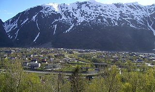
Trofors is the administrative centre of the municipality of Grane in Nordland county, Norway. It is located at the confluence of the rivers Austervefsna and Svenningdalselva which forms the large river Vefsna. The village of Leiren lies about 25 kilometres (16 mi) to the southeast and the village of Majavatn lies about 45 kilometres (28 mi) to the south.

Kjøpsvik (Norwegian) or Gásluokta (Northern Sami) is a village in Narvik Municipality in Nordland county, Norway. The village is located on the eastern shore of the Tysfjorden, north of the small village of Storå. The island of Hulløya lies off the coast of Kjøpsvik. The 1.01-square-kilometre (250-acre) village has a population (2018) of 845 which gives the village a population density of 837 inhabitants per square kilometre (2,170/sq mi).
Varntresk is a village in the municipality of Hattfjelldal in Nordland county, Norway. The village is located on the eastern shore of the large lake Røssvatnet. The lake Famnvatnet lies about 8 kilometres (5.0 mi) east of the village. Varntresk Church is located in this village, and it serves the northern part of the municipality. There is also a small school in Varntresk. The village of Hattfjelldal, the municipal centre, lies about 30 kilometres (19 mi) to the south.
Svenskvollen is a village in the municipality of Hattfjelldal in Nordland county, Norway. The village lies along the river Vefsna in the Susendal valley, just north of Børgefjell National Park. The village is home to Susendal Church, which serves the southern part of Hattfjelldal. The village of Hattfjelldal, the municipal centre, lies about 25 kilometres (16 mi) to the north.


