
Thiruvananthapuram, is the capital city of the Indian state of Kerala. It is the most populous city in Kerala with a population of 957,730 as of 2011. The encompassing urban agglomeration population is around 1.68 million. Located on the west coast of India near the extreme south of the mainland, Thiruvananthapuram is a major information technology hub in Kerala and contributes 55% of the state's software exports as of 2016. Referred to by Mahatma Gandhi as the "Evergreen city of India", the city is characterised by its undulating terrain of low coastal hills.

Neyyattinkara, is a significant municipal town and a prominent center for both industry and commerce, positioned at the southernmost tip of the Thiruvananthapuram metropolitan area in Trivandrum, the capital of Kerala State. It also serves as the administrative headquarters of Neyyattinkara Taluk.Nestled along the banks of the Neyyar River, one of the district's principal rivers, the town derives its name from its location, with 'Neyyatinkara' in Malayalam translating to 'the shore of the river Neyyar.' Neyyattinkara ranks as the second most densely populated municipality in the district, following Varkala. Notably, the Vizhinjam International Seaport Thiruvananthapuram is situated within Neyyattinkara Taluk."

Nedumangad is a municipal town in the Thiruvananthapuram district in the Indian state of Kerala. It is the headquarters of Nedumangad Tehsil and Nedumangad Revenue Division. It is a suburb of the extended metropolitan region of Thiruvananthapuram. It is located around 16 km (9.9 mi) to the north-east of Thiruvananthapuram on the State Highway 2. It is an important commercial center in the district. It is a growing commercial and educational hub and all important government institutions are situated in the town. The Nedumangadu market has significance in southern Kerala.

Thiruvananthapuram District is the southernmost district in the Indian state of Kerala. The district was created in 1949, with its headquarters in the city of Thiruvananthapuram, which is also Kerala's administrative centre. The present district was created in 1956 by separating the four southernmost Taluks of the erstwhile district to form Kanyakumari district. The city of Thiruvananthapuram is also known as the Information technology capital of the State, since it is home to the first and largest IT park in India, Technopark, established in 1990. The district is home to more than 9% of total population of the state.

Pampady is a major town in Kottayam district of Kerala, Southern India. It lies midway between the backwaters of Western Kerala and the mountains of the Western Ghats.
Kaniyapuram is a residential and IT industrial area of Thiruvananthapuram metropolitan area of Trivandrum city around 14 kilometres (8.7 mi) from Thiruvananthapuram, Kerala, India. The main centre of Kaniyapuram area is located in NH-66 in between Kazhakkoottam and Pallippuram CRPF Base. The Kaniyapuram locality is a vast area and expands to; Andoorkonam in the East, Parvathy Puthanar in the West, Vetturoad in the South and Pallippuram in the North. The Kaniyapuram town belongs to the Andoorkonam Panchayat, although Andoorkonam still remains a village 3 kilometres (1.9 mi) to the east.The main town in Kaniyapuram is Alummoodu junction.

Pappinisseri is a census town and a suburb of Kannur city in Kannur district in the Indian state of Kerala. Pappinissery have consistently won the Swaraj Trophy for best Grama Panchayat from 2017-2018 to 2021. Pappinisseri Panchayat also bagged the third position in the Swaraj Trophy during 2015-2016. Also, Pappinissery has been declared as the best Grama Panchayat in Kerala by Kerala government. Pappinisseri Panchayat comprises two villages, viz Pappinisseri and Aroli. Pappinisseri better known for visha chikitsa kendram
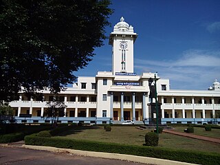
Sree Chitra Thirunal College of Engineering (SCTCE) or SCT College of Engineering is a State Government sponsored engineering college in Thiruvananthapuram, Kerala, India. It was established in 1995 by the Government of Kerala.

Chathannoor is a town in the Indian state of Kerala situated at the Kollam District on the banks of Ithikkara River. It is about 16 km (9.9 mi) from Kollam(Quilon) City. Chathannoor is around 55 km (34 mi) north of the state capital Thiruvananthapuram(Trivandrum). Chathannoor is a Special Grade Panchayath and is one of the fastest developing towns in Kerala.. Shri ChandraKumar is the current president of Chathannoor Grama Panchayat.
Vattiyoorkavu is located in the north-eastern side of Thiruvananthapuram (Trivandrum) city, Kerala, India. Killi River and Karamana River flows through this area. It is one among the four legislative constituencies which are a part of Thiruvananthapuram city and is represented in the Kerala Legislative Assembly by Adv. V. K. Prasanth. It is one of the most important residential suburbs of the city and is an important link in connecting the city with several outer areas such as Kachani, Aruvikkara, Puliyarakonam, etc. It is a comparatively high-lying area of the city. Vattiyoorkavu is one of the greenest parts of the city. Other important area nearby Vattiyoorkavu are Maruthamkuzhi, Sasthamangalam, Elippodu, Kulasekharam etc. It comes under the jurisdiction of Vattiyoorkavu police station which is located in Vattiyoorkavu junction. Vattiyoorkavu has its own post office (PIN-695013), telecom Exchange and electricity (KSEB) section as well. There are regular buses to Kizhakekotta as well as other areas of the city which pass through the Vattiyoorkavu bus stop. Two auto stands and one taxi stand are also present near the junction.
The importance and antiquity of education in Kerala are underscored by the state's ranking as among the most literate in the country. The educational transformation of Kerala was triggered by the efforts of the Church Mission Society missionaries, who were the pioneers that promoted mass education in Kerala, in the early decades of the 19th century. The local dynastic precursors of modern-day Kerala—primarily the Travancore Royal Family, the Nair Service Society, Sree Narayana Dharma Paripalana Yogam and Muslim Educational Society (MES)—also made significant contribution to the progress on education in Kerala. Local schools were known by the general word kalaris, some of which taught martial arts, but other village schools run by Ezhuthachans were for imparting general education. Christian missionaries and British rule brought the modern school education system to Kerala. Ezhuthu palli was the name used in earlier times. The word was derived from the schools run by the Buddhist monasteries. For centuries villages used to set up an ezhuthupally or ashan pallikoodam with one or two teachers. Students used to go this school from nearby areas and learn languages, literature, mathematics, grammar etc. After completing this students may continue study about specific subjects such as ayurveda, astrology, accounting etc. Censuses during 1800 shows that Travancore, Cochin, Kannur areas have many such schools. Even name list of ashans were used to be published along with the census.
Parassala is a small town located near the border of Kerala and Tamil Nadu.It comes under Thiruvananthapuram district at southern tip of Kerala. It is situated 34 km south of state capital Thiruvananthapuram in Kerala, bordering Tamil Nadu.
Kudavattoor is a small village of the Kottarakara Taluk in the Kollam district of the Indian state of Kerala. In the local Malayalam language, kuda means "umbrella" and vattor "round". A predominantly rural village, Kudavattoor comes under the administration of the Veliyam Grama Panchayat made up of Maroor, Cherukarakonam and Kudavattoor chandhamukku. The village is situated on the odanavattom kollam road, which provides access to Kollam via Kundara or Nedumankavu as well as to Kottarakara. Kollam, the district headquarters is situated about 25 km from Kudavattoor.
Vettikkavala is a village located in the Kollam district in the state of Kerala, India. One point of interest within the village is a Shiva-Vishnu temple which hosts a special deity called Vathukkal Njali Kunju. An annual celebration of Pongala is held at the temple. The village is also well known for temple arts and a palace constructed by Sree Moolam Thirunal.
Manacaud is a locality in Thiruvananthapuram, the capital of Kerala, India. This place is situated between Kamaleswaram and Attakulangara on East Fort - Kovalam - Vizhinjam Road. The United Arab Emirates embassy is also situated in Manacaud.
Pappanamcode(Abode of Mahouts) is a locality of Thiruvananthapuram, the capital of Kerala, India. Only 5 km from Trivandrum central railway station and bus stand. It is one of the major industrial centres in Trivandrum.
Vanchiyoor is a locality in downtown Thiruvananthapuram city, the capital of the India state of Kerala. Vanchiyoor occupies an important place in the history of Travancore. It was the district headquarters and most important offices were situated here. There are a lot of heritage monuments in the area. Major administrative, commercial, government and judicial establishments are still located in Vanchiyoor. It is part of Vanchiyoor Village, which holds the prominent administrative headquarters and landmarks of Kerala. Proximity with major educational institutions, offices and shopping centres coupled with easy road connectivity with all parts of the city make it a favoured residential locale in Thiruvananthapuram. Vanchiyoor is 2 kilometres (1.2 mi) from Statue Junction, about 3 kilometres (1.9 mi) from Palayam and 2 kilometres (1.2 mi) from the central railway and bus stations. Trivandrum International Airport lies 6 kilometres (3.7 mi) to the southwest of Vanchiyoor.
Kamaleswaram is one of the main suburbs of Thiruvananthapuram, the capital of Kerala, India. It boasts having several temples and mosques which are of historic significance. Attukal Temple is located 1 km from Kamaleswaram. Padmanabhaswamy Temple is located 1.5 kms from Kamaleswaram. Manacaud Valiyapalli is located 500 mtrs from Kamaleswaram. It is also in the vicinity of all major public services. The Trivandrum International Airport is located 4 kms from Kamaleswaram. The Trivandrum Central Railway Station is located 3 kms from Kamaleswaram. The East Fort bus terminal is located 2 kms from Kamaleswaram. Kamaleswaram is situated between Kallattumukku and Manacaud.
