Related Research Articles

A broch is an Iron Age drystone hollow-walled structure found in Scotland. Brochs belong to the classification "complex Atlantic roundhouse" devised by Scottish archaeologists in the 1980s. Their origin is a matter of some controversy.

Orkney, also known as the Orkney Islands, is an archipelago in the Northern Isles of Scotland, situated off the north coast of the island of Great Britain. Orkney is 10 miles (16 km) north of the coast of Caithness and has about 70 islands, of which 20 are inhabited. The largest island, the Mainland, has an area of 523 square kilometres (202 sq mi), making it the sixth-largest Scottish island and the tenth-largest island in the British Isles. Orkney’s largest settlement, and also its administrative centre, is Kirkwall.

Shapinsay is one of the Orkney Islands off the north coast of mainland Scotland. There is one village on the island, Balfour, from which roll-on/roll-off car ferries sail to Kirkwall on the Orkney Mainland. Balfour Castle, built in the Scottish Baronial style, is one of the island's most prominent features, a reminder of the Balfour family's domination of Shapinsay during the 18th and 19th centuries; the Balfours transformed life on the island by introducing new agricultural techniques. Other landmarks include a standing stone, an Iron Age broch, a souterrain and a salt-water shower.

The Northern Isles are a pair of archipelagos off the north coast of mainland Scotland, comprising Orkney and Shetland. They are part of Scotland, as are the Hebrides. The climate is cool and temperate and much influenced by the surrounding seas. There are a total of 36 inhabited islands. The landscapes of the fertile agricultural islands of Orkney contrast with the more rugged Shetland islands to the north, where the economy is more dependent on fishing and on the oil wealth of the surrounding seas. Both island groups have a developing renewable energy industry. Both have a Pictish and Norse history. Both were part of the Kingdom of Norway until they were absorbed into the Kingdom of Scotland in the 15th century. They remained part of it until the 1707 formation of the Kingdom of Great Britain and the 1801 formation of the United Kingdom. And they both played a significant naval role during the world wars of the 20th century.
Humans have inhabited Orkney, an archipelago in the north of Scotland, for about 8,800 years: Archeological evidence dates from Mesolithic times. Scandinavian clans dominated the area from the 8th century CE, using the islands as a base for further incursions. In the late 14th century the archipelago became part of Scotland.

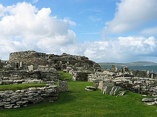
Burroughston Broch is an Iron Age broch located on the island of Shapinsay in the Orkney Islands, in Scotland. The site overlooks the North Sea on the northeast part of Shapinsay. Excavated in the mid 19th century, Burroughston Broch is still well-preserved. The drystone walls are up to four metres thick in some parts and there is a complete chamber intact off the entrance passage. Some remains of stone fittings are evident in the interior.
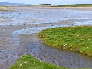
The Ouse is a tidal estuary in northern Shapinsay, Orkney Islands. This water body has been shown on early maps of the island in a very similar shape to its current geometry. The Ouse is fed by small rivulets and upland springs that rise on the western part of the island's northeast spur. pH levels of these feed waters are moderately alkaline, in the range of 9.1.

Mill Dam is a wetland in western Shapinsay, in Orkney, Scotland.

Balfour Castle is a historic building on the southwest of Shapinsay, Orkney Islands. Though built around an older structure that dates at least from the 18th century, the present castle was built in 1847, commissioned by Colonel David Balfour, and designed by Edinburgh architect David Bryce. It is a Category A listed building and the landscape and formal gardens are listed in the Inventory of Gardens and Designed Landscapes in Scotland.

Mor Stein is a neolithic standing stone in the southeastern part of the island of Shapinsay, Orkney Islands, Scotland. Shapinsay is one of the two large inner islands of the Orkney group, and it is situated approximately two miles north of the Orkney Mainland. Linton Bay is situated slightly to the northeast of Mor Stein.

Helliar Holm is an uninhabited island off the coast of Shapinsay in the Orkney Islands, Scotland. It is home to a 42-foot-tall (13 m) lighthouse, which was built in 1893 and automated in 1967. It is a tidal island that used to be connected to Shapinsay. It is still possible to walk across from the mainland during very low tides.

The Bay of Linton is a bay on the east coast on the island of Shapinsay in the Orkney Islands, Scotland. To the north of Linton Bay are the headlands of Ness of Ork, and to the south is The Foot. The ancient monument the Broch of Burroughston is slightly north of Linton Bay.

The Geo of Ork is a narrow and deep cleft in the cliff face of the northernmost point on the island of Shapinsay in the Orkney islands. The term geo or gya derives from Old Norse gjá. This landform was created by the wave driven erosion of cliffs along faults or bedding planes in the rock. A well-preserved prehistoric broch lies slightly to the south of Geo of Ork on the eastern coast of Shapinsay. This drystone broch has extant remains of ancient stone furniture inside.
Lairo Water is a surface water body known as an ayre situated on the western coast of Shapinsay in the Orkney Islands. This brackish water body is separated by a narrow bar of land from Veantro Bay. This wetland is an area where a variety of bird species may be found. Hogan has suggested that the Lairo Water may have been a source of subsistence food for prehistoric inhabitants of Shapinsay at Burroughston Broch.

Castle Bloody is a prehistoric feature on the island of Shapinsay, Orkney, Scotland. Hogan observes that while the feature is marked as a chambered mound on the UK Ordnance Survey map, the structure is more properly and specifically classified as a souterrain or earth house. Slightly to the north is located the ruined historic Linton Chapel.

Quholm is a hamlet in the northeast of Shapinsay, in the islands of Orkney, Scotland. William Irving, the father of Washington Irving, noted American author, was born in Quholm. Innsker Beach is situated very close by at the northwest edge of Quholm. Slightly to the south along Shapinsay's northwest coast are located the coastal ayres of Lairo Water and the Ouse situated within Veantro Bay. There are significant archaeological sites not distant from Quholm, including Odin's Stone, Burroughston Broch, Linton Chapel, Castle Bloody and Mor Stein.
The Broch of Gurness is an Iron Age broch village on the northeast coast of Mainland Orkney in Scotland overlooking Eynhallow Sound, about 15 miles north-west of Kirkwall. It once housed a substantial community.

Prehistoric Orkney refers only to the prehistory of the Orkney archipelago of Scotland that begins with human occupation. Although some records referring to Orkney survive that were written during the Roman invasions of Scotland, “prehistory” in northern Scotland is defined as lasting until the start of Scotland's Early Historic Period.

The Zenith of Iron Age Shetland is a combination of three sites in Shetland that have applied to be on the United Kingdom "Tentative List" of possible nominations for the UNESCO World Heritage Programme list of sites of outstanding cultural or natural importance to the common heritage of humankind. The application was made by the Shetland Amenity Trust in 2010, and in 2011 the site became one of 11 successful UK applications to join the Tentative List, three of them from Scotland.

The Broch of Borwick is an Iron Age broch located on Mainland, Orkney, Scotland. It is a scheduled monument.
References
- ↑ Martin Li (2005). Adventure Guide to Scotland. Hunter Publishing, Inc. p. 620. ISBN 1-58843-406-0.
- ↑ C. Michael Hogan (7 October 2007). "Burroughston Broch". The Megalithic Portal, ed by Andy Burnham. Retrieved 8 August 2009.
- ↑ "Minutes of Shapinsay Community Council". Orkney Community Councils. 2 February 2005. Retrieved 8 August 2009.
Coordinates: 59°4′N2°52′W / 59.067°N 2.867°W
| | This Orkney location article is a stub. You can help Wikipedia by expanding it. |