
Quholm (grid reference HY5221 ) [1] is a farm in the northeast of Shapinsay, in the islands of Orkney, Scotland. [2]
Quholm (grid reference HY5221 ) [1] is a farm in the northeast of Shapinsay, in the islands of Orkney, Scotland. [2]
Slightly to the south along Shapinsay's northwest coast are located the coastal ayres of Lairo Water and the Ouse situated within Veantro Bay. There are significant archaeological sites not distant from Quholm, including Odin's Stone, Burroughston Broch, Linton Chapel, Castle Bloody and Mor Stein.
William Irving, the father of Washington Irving, noted American author, was born in Quholm. Innsker Beach is situated very close by at the northwest edge of Quholm. [3]

Orkney, also known as the Orkney Islands or The Orkneys, is an archipelago in the Northern Isles of Scotland, situated off the north coast of the island of Great Britain. Orkney is 10 miles (16 km) north of the coast of Caithness and has about 70 islands, of which 20 are inhabited. The largest island, the Mainland, has an area of 523 square kilometres (202 sq mi), making it the sixth-largest Scottish island and the tenth-largest island in the British Isles. Orkney's largest settlement, and also its administrative centre, is Kirkwall.

Stronsay is an island in Orkney, Scotland. It is known as Orkney's 'Island of Bays', owing to an irregular shape with miles of coastline, with three large bays separated by two isthmuses: St Catherine's Bay to the west, the Bay of Holland to the south and Mill Bay to the east. Stronsay is 3,275 hectares in area, and 44 metres in altitude at its highest point. It has a usually resident population of 349. The main village is Whitehall, home to a heritage centre.

Shapinsay is one of the Orkney Islands off the north coast of mainland Scotland. There is one village on the island, Balfour, from which roll-on/roll-off car ferries sail to Kirkwall on the Orkney Mainland. Balfour Castle, built in the Scottish Baronial style, is one of the island's most prominent features, a reminder of the Balfour family's domination of Shapinsay during the 18th and 19th centuries; the Balfours transformed life on the island by introducing new agricultural techniques. Other landmarks include a standing stone, an Iron Age broch, a souterrain and a salt-water shower.

Wyre is one of the Orkney Islands, lying south-east of Rousay. It is 311 hectares (1.20 sq mi) and 32 metres (105 ft) at its highest point. It is one of the smallest inhabited islands in the archipelago.
Orkney Ferries is a Scottish company operating inter-island ferry services in the Orkney Islands. The company operates ferry services across 15 islands.

Burroughston Broch is an Iron Age broch located on the island of Shapinsay in the Orkney Islands, in Scotland. The site overlooks the North Sea on the northeast part of Shapinsay. Excavated in the mid 19th century, Burroughston Broch is still well-preserved. The drystone walls are up to four metres thick in some parts and there is a complete chamber intact off the entrance passage. Some remains of stone fittings are evident in the interior.

Mill Dam is a wetland in western Shapinsay, in Orkney, Scotland.

Balfour Castle is a historic building on the southwest of Shapinsay, Orkney Islands. Though built around an older structure that dates at least from the 18th century, the present castle was built in 1847, commissioned by Colonel David Balfour, and designed by Edinburgh architect David Bryce. It is a Category A listed building and the landscape and formal gardens are listed in the Inventory of Gardens and Designed Landscapes in Scotland.

Mor Stein is a neolithic standing stone in the southeastern part of the island of Shapinsay, Orkney Islands, Scotland. Shapinsay is one of the two large inner islands of the Orkney group, and it is situated approximately two miles north of the Orkney Mainland. Linton Bay is situated slightly to the northeast of Mor Stein.

Balfour is a village on the island of Shapinsay, Orkney. The village is situated on Elwick Bay, which was used as an anchorage by Haakon IV of Norway before sailing south to eventual defeat at the Battle of Largs in 1263. Today, the village still possesses a harbour, with mock defensive walls constructed at the same time as the castle. David Balfour even added a stone marked with the date 1725, taken from Noltland Castle on the island of Westray, to his defences. A car ferry to Kirkwall, operated by Orkney Ferries, sails from a pier at the harbour. This became a roll-on/roll-off service in 1990.

Helliar Holm is an uninhabited island off the coast of Shapinsay in the Orkney Islands, Scotland. It is home to a 42-foot-tall (13 m) lighthouse, which was built in 1893 and automated in 1967. It is a tidal island that used to be connected to Shapinsay. It is still possible to walk across from the mainland during very low tides.

Thieves Holm is a small island in Orkney, Scotland.

The European Marine Energy Centre (EMEC) Ltd is a UKAS accredited test and research center focused on wave and tidal power development, based in the Orkney Islands, UK. The centre provides developers with the opportunity to test full-scale grid-connected prototype devices in wave and tidal conditions.

The Geo of Ork is a narrow and deep cleft in the cliff face of the northernmost point on the island of Shapinsay in the Orkney islands. The term geo or gya derives from Old Norse gjá. This landform was created by the wave driven erosion of cliffs along faults or bedding planes in the rock. A well-preserved prehistoric broch lies slightly to the south of Geo of Ork on the eastern coast of Shapinsay. This drystone broch has extant remains of ancient stone furniture inside.
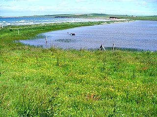
Lairo Water is a surface water body known as an ayre situated on the western coast of Shapinsay in the Orkney Islands. This brackish water body is separated by a narrow bar of land from Veantro Bay. This wetland is an area where a variety of bird species may be found. Hogan has suggested that the Lairo Water may have been a source of subsistence food for prehistoric inhabitants of Shapinsay at Burroughston Broch.
Veantro Bay is a bay on the northwest coast of Shapinsay in the Orkney Islands, Scotland.

Castle Bloody is a prehistoric feature on the island of Shapinsay, Orkney, Scotland. Hogan observes that while the feature is marked as a chambered mound on the UK Ordnance Survey map, the structure is more properly and specifically classified as a souterrain or earth house. Slightly to the north is located the ruined historic Linton Chapel.

Linton Chapel is a ruined chapel on the east coast of Shapinsay, Orkney. The chapel is thought to date as early as the 12th century AD. Slightly to the south is a megalithic monument, Castle Bloody.

The Point of Hellia is a headland on the northwest coast of the Orkney Mainland, Scotland. This landform extends into the southern part of Eynhallow Sound, a seaway of the North Sea.
59°04′24″N2°50′20″W / 59.0732°N 2.8390°W
| | This article related to Orkney is a stub. You can help Wikipedia by expanding it. |