Related Research Articles
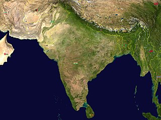
India is situated north of the equator between 8°4' north to 37°6' north latitude and 68°7' east to 97°25' east longitude. It is the seventh-largest country in the world, with a total area of 3,287,263 square kilometres (1,269,219 sq mi). India measures 3,214 km (1,997 mi) from north to south and 2,933 km (1,822 mi) from east to west. It has a land frontier of 15,200 km (9,445 mi) and a coastline of 7,516.6 km (4,671 mi).

Shravanabelagola is a town located near Channarayapatna of Hassan district in the Indian state of Karnataka and is 144 km (89 mi) from Bengaluru. The Gommateshwara Bahubali statue at Shravanabelagola is one of the most important tirthas in Jainism, one that reached a peak in architectural and sculptural activity under the patronage of Western Ganga dynasty of Talakad. Chandragupta Maurya is said to have died on the hill of Chandragiri, which is located in Shravanabelagola, in 298 BCE after he became a Jain monk and assumed an ascetic life style.
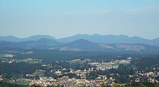
Ooty, officially known as Udhagamandalam ; abbreviated as Udhagai), is a town and a municipality in the Nilgiris district of the South Indian state of Tamil Nadu. It is located 86 km (53 mi) north west of Coimbatore, 100 km (65 mi) north west of Tirupur, 128 km (80 mi) south of Mysore and is the headquarters of the Nilgiris district. It is a popular hill station located in the Nilgiri Hills. It is popularly called the "Queen of Hill Stations". It was the summer capital of the Madras Presidency.

The Western Ghats, also known as the Sahyadri mountain range, is a mountain range that covers an area of 160,000 km2 (62,000 sq mi) in a stretch of 1,600 km (990 mi) parallel to the western coast of the Indian peninsula, traversing the states of Gujarat, Maharashtra, Goa, Karnataka, Kerala and Tamil Nadu. It is a UNESCO World Heritage Site and is one of the 36 biodiversity hotspots in the world. It is sometimes called the Great Escarpment of India. It contains a very large proportion of the country's flora and fauna, many of which are endemic to this region. The Western Ghats are older than the Himalayas. They influence Indian monsoon weather patterns by intercepting the rain-laden monsoon winds that sweep in from the south-west during late summer. The range runs north to south along the western edge of the Deccan Plateau and separates the plateau from a narrow coastal plain called the Western Coastal Plains along the Arabian Sea. A total of 39 areas in the Western Ghats, including national parks, wildlife sanctuaries and reserve forests, were designated as world heritage sites in 2012 – twenty in Kerala, ten in Karnataka, six in Tamil Nadu and four in Maharashtra.

Darjeeling is a town and municipality in the northernmost region of the Indian state of West Bengal. Located in the Eastern Himalayas, it has an average elevation of 2,045 metres (6,709 ft). To the west of Darjeeling lies the easternmost province of Nepal, to the east the Kingdom of Bhutan, to the north the Indian state of Sikkim, and farther north the Tibet Autonomous Region region of China. Bangladesh lies to the south and southeast, and most of the state of West Bengal lies to the south and southwest, connected to the Darjeeling region by a narrow tract. Kangchenjunga, the world's third-highest mountain, rises to the north and is prominently visible on clear days.

Jharkhand is a state in eastern India. The state shares its border with the states of West Bengal to the east, Chhattisgarh to the west, Uttar Pradesh to the northwest, Bihar to the north and Odisha to the south. It is the 15th largest state by area, and the 14th largest by population. Hindi is the official language of the state. The city of Ranchi is its capital and Dumka its sub-capital. The state is known for its waterfalls, hills and holy places; Baidyanath Dham, Parasnath, Dewri and Rajrappa are major religious sites.

Meghalaya is a state in northeast India. Meghalaya was formed on 21 January 1972 by carving out two districts from the state of Assam: (a) the United Khasi Hills and Jaintia Hills and (b) the Garo Hills. The population of Meghalaya as of 2014 is estimated to be 3,211,474. Meghalaya covers an area of approximately 22,429 square kilometres, with a length-to-breadth ratio of about 3:1.

The Chittagong Hill Tracts, often shortened to simply the Hill Tracts and abbreviated to CHT, are group of districts within the Chittagong Division in southeastern Bangladesh, bordering India and Myanmar (Burma). Covering 13,295 square kilometres (5,133 sq mi), they formed a single district until 1984, when they were divided into three districts: Khagrachari District, Rangamati Hill District, and Bandarban District.

The Vindhya Range is a complex, discontinuous chain of mountain ridges, hill ranges, highlands and plateau escarpments in west-central India.

The Chota Nagpur Plateau is a plateau in eastern India, which covers much of Jharkhand state as well as adjacent parts of Chhattisgarh, Odisha, West Bengal and Bihar. The Indo-Gangetic plain lies to the north and east of the plateau, and the basin of the Mahanadi river lies to the south. The total area of the Chota Nagpur Plateau is approximately 65,000 square kilometres (25,000 sq mi).

The Aravalli Range is a mountain range in Northern-Western India, running approximately 670 km (420 mi) in a south-west direction, starting near Delhi, passing through southern Haryana, Rajasthan, and ending in Ahmedabad Gujarat. The highest peak is Guru Shikhar on Mount Abu at 1,722 m (5,650 ft). The Aravalli Range is arguably the oldest geological feature on Earth, having its origin in the Proterozoic era.

South Mumbai, colloquially SoBo from South Bombay in Indian English, administratively the Mumbai City District, is the city centre and the southernmost precinct of Greater Bombay. It extends from Colaba to Mahim and Sion neighbourhoods, and comprises the city's main business localities, making it the wealthiest urban precinct in India. Property prices in South Mumbai are by far the highest in India and among the highest in the world.
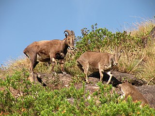
The Nilgiri tahr is an ungulate that is endemic to the Nilgiri Hills and the southern portion of the Western and Eastern Ghats in the states of Tamil Nadu and Kerala in southern India. It is the only species in the genus Nilgiritragus and is closely related to the sheep of the genus Ovis.

A hill station is a town located at a higher elevation than the nearby plain or valley. The term was used mostly in colonial Asia, but also in Africa, for towns founded by European colonialists as refuges from the summer heat and, as Dale Kennedy observes about the Indian context, "the hill station ... was seen as an exclusive British preserve: here it was possible to render the Indian into an outsider". In India, which has the largest number of hill stations, most are situated at an altitude of approximately 1,000 to 2,500 metres.

The Sivalik Hills, also known as the Shivalik Hills and Churia Hills, are a mountain range of the outer Himalayas that stretches over about 2,400 km (1,500 mi) from the Indus River eastwards close to the Brahmaputra River, spanning the northern parts of the Indian subcontinent. It is 10–50 km (6.2–31.1 mi) wide with an average elevation of 1,500–2,000 m (4,900–6,600 ft). Between the Teesta and Raidāk Rivers in Assam is a gap of about 90 km (56 mi). The literal translation of "Sivalik" is 'tresses of Shiva'. Sivalik region is home to the Soanian archaeological culture. The hills are well known for their Neogene and Pleistocene aged vertebrate fossils.
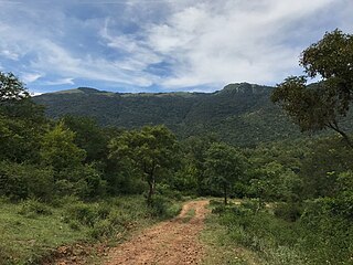
The Biligirirangana Hills or Biligirirangan Hills is a hill range situated in south-western Karnataka, at its border with Tamil Nadu in South India. The area is called Biligiri Ranganatha Swamy Temple Wildlife Sanctuary or simply BRT Wildlife Sanctuary. It is a protected reserve under the Wildlife Protection Act of 1972. Being close to the Eastern Ghats as well as the Western Ghats, the sanctuary has floral and faunal associations with both regions. The site was declared a tiger reserve in January 2011 by the Government of Karnataka, a few months after approval from India's National Tiger Conservation Authority.

Raisina Hill, often used as a metonym for the seat of the Government of India, is an area of New Delhi, housing India's most important government buildings, including Rashtrapati Bhavan, the official residence of the president of India on a citadel at Raisina Hill and the Secretariat building housing the Prime Minister's Office and several other important ministries. The hill is seen as an Indian acropolis with Rashtrapati Bhavan as the Parthenon.

Periyar, IPA:[peɾijɐːr], is the longest river and the river with the largest discharge potential in the Indian state of Kerala. It is one of the few perennial rivers in the region and provides drinking water for several major towns. The Periyar is of utmost significance to the economy of Kerala. It generates a significant proportion of Kerala's electrical power via the Idukki Dam and flows along a region of industrial and commercial activity. The river also provides water for irrigation and domestic use throughout its course besides supporting a rich fishery. Due to these reasons, the river has been named the "Lifeline of Kerala". Kochi city, in the vicinity of the river mouth draws its water supply from Aluva, an upstream site sufficiently free of seawater intrusion. Twenty five percent of Kerala's industries are along the banks of river Periyar. These are mostly crowded within a stretch of 5 kilometres (3 mi) in the Eloor-Edayar region (Udhyogamandal), about 10 kilometres (6 mi) north of Kochi harbor.
Film Nagar, also known as Tinsel Town or Tollywood, is a neighborhood in the western part of Hyderabad, Telangana, India. It is notable for its place as the home of the entertainment industry, including several of Telugu cinema's historic studios. The area is majorly a part of Jubilee Hills and also a small part of Banjara Hills. The area is the headquarters of Telugu film industry, and the residential hub of many Telugu film personalities like Chiranjeevi, Daggubati Venkatesh, Allu Arjun, Nagarjuna, Junior NTR, Brahmaji, Mohan Babu, Balakrishna etc. to name a few.
The Republic of India shares borders with several sovereign countries; it shares land borders with China, Bhutan, Nepal, Pakistan, Bangladesh and Myanmar. Bangladesh and Pakistan share both land borders as well as maritime borders, while Sri Lanka shares only a maritime border through Ram Setu. India's Andaman and Nicobar Islands share a maritime border with Thailand, Myanmar, and Indonesia.
References
- ↑ Tourist Guide to South India. Sura Books. 2003. p. 202. ISBN 9788174781758.
 | This article related to a location in Kerala is a stub. You can help Wikipedia by expanding it. |