Vefsnfjord

Last updated
Vefsnfjorden
Vefsnfjord
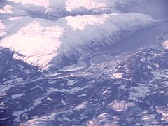
Vefsnfjorden og Leirfjorden fra fly.jpg
View of the fjord
Norway Nordland location map.svg
Red pog.svg
Vefsnfjord
Location of the fjord
Relief Map of Norway.png
Red pog.svg
Vefsnfjord
Vefsnfjord (Norway)
Location Nordland county, Norway
Coordinates 65°54′17″N12°36′38″E / 65.9047°N 12.6106°E / 65.9047; 12.6106 Coordinates: 65°54′17″N12°36′38″E / 65.9047°N 12.6106°E / 65.9047; 12.6106
Type Fjord
Basin  countries Norway
Max. length51 kilometres (32 mi)
Max. depth440 metres (1,440 ft)
Settlements Mosjøen

The Vefsnfjord or Vefsnfjorden is a fjord in the Helgeland traditional district of Nordland county, Norway. It is about 51 kilometres (32 mi) long, reaching a maximum depth of about 440 metres (1,440 ft) below sea level. The fjord flows through the municipalities of Alstahaug, Leirfjord, and Vefsn.

Fjord A long, narrow inlet with steep sides or cliffs, created by glacial activity

Geologically, a fjord or fiord is a long, narrow inlet with steep sides or cliffs, created by a glacier. There are many fjords on the coasts of Alaska, Antarctica, British Columbia, Chile, Greenland, the Faroe Islands, Iceland, Kamchatka, the Kerguelen Islands, New Zealand, Norway, Novaya Zemlya, Labrador, Nunavut, Newfoundland, Quebec, Scotland, South Georgia Island, and Washington state. Norway's coastline is estimated at 29,000 kilometres (18,000 mi) with nearly 1,200 fjords, but only 2,500 kilometres (1,600 mi) when fjords are excluded.

Helgeland region in Northern Norway

Helgeland is the most southerly district in Northern Norway. Generally speaking, Helgeland refers to the part of Nordland county that is located south of the Arctic Circle. It is bordered in the north by the Saltfjellet mountains and Svartisen glacier, which form a natural border with the Salten district. In the south, Helgeland borders Trøndelag county.

The country Norway is historically divided into a number of districts. Many districts have deep historical roots, and only partially coincide with today's administrative units of counties and municipalities. The districts are defined by geographical features, often valleys, mountain ranges, fjords, plains, or coastlines, or combinations of the above. Many such regions were petty kingdoms up to the early Viking age.

Contents

The fjord begins at Tjøtta, south of the island of Alsten and meets the Leirfjord at the island of Sundøy before turning to the south as it proceeds inland to the town of Mosjøen. The outer part of the fjord is also called Sørfjord. [1]

Tjøtta (island) island in the municipality of Alstahaug in Nordland county, Norway

Tjøtta is an island in Alstahaug Municipality in Nordland county, Norway. The 11.3-square-kilometre (4.4 sq mi) island lies at the entrance to the Vefsnfjorden, just south of the island of Alsta. The U-shaped island is relatively flat, and the highest point is the 77-metre (253 ft) tall Kalvberghaugen, just east of the village of Tjøtta. The island has two main villages on it: Tjøtta and Svinnes. The Norwegian County Road 17 crosses the island and it connects it to the neighboring islands of Offersøya and Alsta by two causeways.

Leirfjord Municipality in Nordland, Norway

Leirfjord is a municipality in Nordland county, Norway. It is part of the Helgeland traditional region. The administrative centre of the municipality is the village of Leland. Other villages in Leirfjord include Bardalssjøen and Sundøy. The large Helgeland Bridge is partly located in the municipality, connecting it to Alstahaug Municipality and the town of Sandnessjøen.

Several large rivers run into the Vefsnfjord, including the Vefsna, Fusta, and Drevja. All three of the rivers are traditionally excellent salmon fishing rivers, although they now have been infected with the salmon parasite Gyrodactylus salaris.

Vefsna river in Norway

Vefsna (Norwegian), also known as Vaapstenjeanoe (Southern Sami) or Vapstälven (Swedish), is the largest river in Nordland county, Norway. It is 163 kilometres (101 mi) long and drains a watershed of 4,122 square kilometres (1,592 sq mi). Its headwaters lie in the mountains of Børgefjell National Park at the lake Simskardvatnet. The river runs through the municipalities of Hattfjelldal, Grane, and Vefsn. The southern parts of the river are sometimes called the river Susna. The river flows north, not far from the Swedish border, and some of the minor tributaries come from Sweden. At the town of Mosjøen, the river discharges into the Vefsnfjord. The Laksforsen waterfall lies along its course.

Salmon Family of fish related to trout

Salmon is the common name for several species of ray-finned fish in the family Salmonidae. Other fish in the same family include trout, char, grayling and whitefish. Salmon are native to tributaries of the North Atlantic and Pacific Ocean. Many species of salmon have been introduced into non-native environments such as the Great Lakes of North America and Patagonia in South America. Salmon are intensively farmed in many parts of the world.

<i>Gyrodactylus salaris</i> species of worm

Gyrodactylus salaris, commonly known as salmon fluke, is a tiny monogenean ectoparasite which lives on the body surface of freshwater fish. This leech-like parasite has been implicated in the reduction of Atlantic salmon populations in the Norwegian fjords. It also parasitises other species, including rainbow trout. G. salaris requires fresh water, but can survive in brackish water for up to 18 hours.

A German prisoner ship was sunk here by British Aircraft during World War II with major loss of life. A memorial is located on a nearby island.

World War II 1939–1945 global war

World War II, also known as the Second World War, was a global war that lasted from 1939 to 1945. The vast majority of the world's countries—including all the great powers—eventually formed two opposing military alliances: the Allies and the Axis. A state of total war emerged, directly involving more than 100 million people from over 30 countries. The major participants threw their entire economic, industrial, and scientific capabilities behind the war effort, blurring the distinction between civilian and military resources. World War II was the deadliest conflict in human history, marked by 50 to 85 million fatalities, most of whom were civilians in the Soviet Union and China. It included massacres, the genocide of the Holocaust, strategic bombing, premeditated death from starvation and disease, and the only use of nuclear weapons in war.

A powerline crosses Vefsnfjord near Overtroan with a 3.236-kilometre (2.011 mi) long span.

See also

Related Research Articles

Nordland County (fylke) of Norway

Nordland is a county in Norway in the Northern Norway region, bordering Troms in the north, Trøndelag in the south, Norrbotten County in Sweden to the east, Västerbotten County to the southeast, and the Atlantic Ocean to the west. The county was formerly known as Nordlandene amt. The county administration is in Bodø. The remote Arctic island of Jan Mayen has been administered from Nordland since 1995.

Naustdal Municipality in Sogn og Fjordane, Norway

Naustdal is a municipality in Sogn og Fjordane county, Norway. It is located in the traditional district of Sunnfjord. The administrative centre is the village of Naustdal, which has 1,188 inhabitants (2017). Other villages in Naustdal include Indrevevring and Helle.

Alstahaug Municipality in Nordland, Norway

Alstahaug is a municipality in Nordland county, Norway. It is part of the Helgeland region. The administrative centre of the municipality is the town of Sandnessjøen. Some of the villages in Alstahaug include Søvika and Tjøtta.

Nesna Municipality in Nordland, Norway

Nesna is a municipality in Nordland county, Norway. It is part of the Helgeland traditional region. The administrative centre of the municipality is the village of Nesna. Other villages in Nesna include Handnesneset, Husby, Saura, and Vikholmen.

Sundøy Village in Northern Norway, Norway

Sundøy or Sundøya is a village in the municipality of Leirfjord in Nordland county, Norway. The village is located about 5 kilometres (3.1 mi) south of the village of Leland. Sundøya has a population of about 120 people. It is located on the north side of the Vefsnfjorden on the northeastern part of the island of Alsta, east of the Seven Sisters mountains, which isolate it from the rest of the island. Since Sundøy is surrounded by mountains and water, it was only accessible by boat until 2003 when the Sundøy Bridge was built, providing a road connection to the mainland of Leirfjord.

Hardangerfjord fjord in Hordaland, Norway

The Hardangerfjord is the fourth longest fjord in the world, and the second longest fjord in Norway. It is located in Hordaland county in the Hardanger region. The fjord stretches 179 kilometres (111 mi) from the Atlantic Ocean into the mountainous interior of Norway along the Hardangervidda plateau. The innermost point of the fjord reaches the town of Odda.

Alsta island in Nordland, Norway

Alsta is an island in the municipalities of Alstahaug and Leirfjord in Nordland county, Norway. The island is surrounded by the Vefsnfjorden to the east, the Leirfjorden to the north, and the Alstenfjorden to the south and west. The eastern part of the island is dominated by the Seven Sisters mountain range which has five mountains that are more than 1,000 metres (3,300 ft) tall, while the western part of the island is relatively flat and it is the location of the town of Sandnessjøen and the village of Søvika in the south.

Trondheim Fjord inlet of the Norwegian Sea in Norway

The Trondheim Fjord or Trondheimsfjorden, an inlet of the Norwegian Sea, is Norway's third-longest fjord at 130 kilometres (81 mi) long. It is located in the west-central part of the country in Trøndelag county, and it stretches from the municipality of Ørland in the west to the municipality of Steinkjer in the north, passing the city of Trondheim on its way. Its maximum depth is 617 metres (2,024 ft), between Agdenes and Indre Fosen.

Namsen river in Trøndelag, Norway

Namsen (Norwegian) or Nååmesje (Southern Sami) is one of the longest rivers in Trøndelag county, in the central part of Norway. The 228-kilometre (142 mi) long river flows through the municipalities of Røyrvik, Namsskogan, Grong, Overhalla, and Namsos before emptying into the Namsenfjorden. The river is the namesake for the whole Namdalen region. The river traditionally has been used for floating timber down from the forests to the town of Namsos, where the sawmills were located. Today, parts of the Namsen are regulated by several dams.

Ranfjord fjord in Nordland, Norway

The Ranfjorden is a fjord in the Helgeland district of Nordland county, Norway. The largest part of the fjord is in the municipality of Rana, but the fjord also passes through the municipalities of Hemnes, Vefsn, Leirfjord, Nesna, and Dønna. The river Ranelva meets the Ranfjord in at the town of Mo i Rana at the innermost part of the fjord. It then flows to the west for about 68 kilometres (42 mi) to where it meets the sea along the border of Dønna and Nesna municipalities.

Hundålvatnet lake in Vefsn, Norway

Hundålvatnet is a lake that lies in the municipality of Vefsn in Nordland county, Norway. The 7.96-square-kilometre (3.07 sq mi) lake lies in the western part of the municipality, about 12 kilometres (7.5 mi) west of the town of Mosjøen. It is located just north of the Lomsdal–Visten National Park. The lake flows into the Hundåla river which flows north into the Vefsnfjorden.

Dalsfjorden (Sunnfjord) fjord in Sogn og Fjordane, Norway

Dalsfjorden is a fjord in Sogn og Fjordane county, Norway. It is located in the municipalities of Askvoll, Fjaler, and Gaular. It is one of the two main fjords that comprise the Sunnfjord region of the county. The fjord is about 40 kilometres (25 mi) long and it is generally about 0.5 to 1 kilometre wide.

Snigsfjorden

Snigsfjorden or Sniksfjorden is a fjord in Lyngdal municipality in Vest-Agder county, Norway. The 3-kilometre (1.9 mi) long fjord begins at the mouth of the river Audna by the small village of Snig, about 4 kilometres (2.5 mi) south of the municipal centre of Vigeland. The fjord heads south to the North Sea. The east side of the fjord is the mainland of Norway and the west side of the fjord is bounded by the island of Unnerøy. The two small islets of Fløyholmen and Tolleknivane are located at the mouth of the fjord. The small Navarsundet strait runs between Unnerøy island and the mainland on the west side of the fjord, connecting it to the nearby Syrdalsfjorden.

Altafjord fjord in Finnmark, Norway

Altafjord is a fjord in Alta Municipality in Finnmark county, Norway. The 38-kilometre (24 mi) long fjord stretches from the town of Alta in the south to the islands of Stjernøya and Seiland. The 200-kilometre (120 mi) long river Altaelva empties into the fjord at the town of Alta. At Stjernøya and Seiland islands, the fjord splits into two straits before emptying into the Norwegian Sea. Some of the larger side-branches off the main fjord include Langfjorden, Kåfjorden, and Korsfjorden.

Bardalssjøen Village in Northern Norway, Norway

Bardalssjøen or Bardal is a village in the municipality of Leirfjord in Nordland county, Norway. The village is located along the south coast of the Ranfjorden, about 10 kilometres (6.2 mi) west of the village of Hemnesberget. The village surrounds the Bardalselva river which flows into the fjord. The Bardal Church was built in 1887 on a hill near the mouth of the river. The Bardal area has historically been part of both Nesna Municipality and Hemnes Municipality, but it has been part of Leirfjord Municipality since 1964.

Leirfjorden fjord in Leirfjord/Alstahaug, Norway

Leirfjorden is a fjord in the municipalities of Leirfjord and Alstahaug in Nordland county, Norway. The 20-kilometre (12 mi) long fjord is located east of the town of Sandnessjøen, between the mainland and the island of Alsta. There is a short strait that connects it to the Vefsnfjorden to the south.

Fedafjorden

Fedafjorden is a fjord in Vest-Agder county, Norway. The 15-kilometre (9.3 mi) is located in the municipalities of Kvinesdal, Flekkefjord, and Farsund. The long, narrow fjord runs south from the mouth of the river Kvina to the Listafjorden.

Gulafjorden is a fjord in Gulen Municipality in Sogn og Fjordane county, Norway. The historic Gulating assemblies in medieval Norway took place in this area. Today, there are several salmon fish farms in the fjord.

Toven Tunnel road tunnel in Nordland, Norway

The Toven Tunnel is a 10,665-metre-long (6.627 mi) road tunnel connecting Leirfjord and Vefsn municipalities, both in Nordland county in northern Norway. The tunnel is also the main access to the city of Sandnessjøen. Work on the tunnel started in 2010 and it was opened on 22 November 2014. It is the longest tunnel in Northern Norway.

References

  1. Store norske leksikon. "Vefsnfjorden" (in Norwegian). Retrieved 2011-11-30.