Related Research Articles

Sir Cornthwaite Hector William James Rason, better known as Hector Rason, was the seventh Premier of Western Australia.
The south-west corner drainage region of Western Australia is one of only two temperate and relatively fertile parts of mainland Australia. It covers about 140,000 square kilometres (54,000 sq mi), or a little less than 2% of the continent. For comparison, this is about the same size as North Carolina or a little larger than England.

Western Australia (WA) is divided into regions according to a number of systems.
WAY 79, also referred to as WAY '79 and WAY 1979, was the official 1979 sesquicentennial celebration of the European colonisation of Western Australia.
John Stanley Beard was a British-born forester and ecologist who resided in Australia. Beard studied at the University of Oxford where he completed his doctoral thesis on tropical forestry.
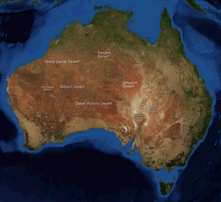
The deserts of Australia or the Australian deserts cover about 2,700,000 km2 (1,000,000 sq mi), or 18% of the Australian mainland, but about 35% of the Australian continent receives so little rain, it is practically desert. Collectively known as the Great Australian desert, they are primarily distributed throughout the Western Plateau and interior lowlands of the country, covering areas from South West Queensland, Far West region of New South Wales, Sunraysia in Victoria and Spencer Gulf in South Australia to the Barkly Tableland in Northern Territory and the Kimberley region in Western Australia.

The Australian Shield, also called the Western Australian Shield, is a geological feature known as a shield that occupies more than half of the continent of Australia. The word shield is used because it refers to ancient, molten rock which has cooled and solidified.

The Western Desert cultural bloc or just Western Desert is a cultural region in central Australia covering about 600,000 square kilometres (230,000 sq mi), including the Gibson Desert, the Great Victoria Desert, the Great Sandy and Little Sandy Deserts in the Northern Territory, South Australia and Western Australia. The Western Desert cultural bloc can be said to stretch from the Nullarbor in the south to the Kimberley in the north, and from the Percival Lakes in the west through to the Pintupi lands in the Northern Territory.

Hampton is an interim Australian bioregion located in southeastern coastal Western Australia, with a small portion (4%) extending into adjacent South Australia. It has an area of 1,088,198 hectares. The Hampton bioregion is part of the Coolgardie woodlands ecoregion.

Western Australia occupies nearly one third of the Australian continent. Due to the size and the isolation of the state, considerable emphasis has been made of these features; it is the second largest administrative territory in the world, after Yakutia in Russia, despite the fact that Australia is only the sixth largest country in the world by area, and no other regional administrative jurisdiction in the world occupies such a high percentage of a continental land mass. It is also the only first level administrative subdivision to occupy the entire continental coastline in one cardinal direction.

The North West, North West Coast, North Western Australia and North West Australia, are usually informal names for the northern regions of the State of Western Australia. However, some conceptions of "North West Australia" have included adjoining parts of the Northern Territory (NT) – or even the entire NT.
This article gives an overview of Australian Aboriginal kinship groupings within Western Australia, with the tribal boundaries based on Norman Tindale's 1974 map, as published in Western Australia: An Atlas of Human Endeavour (1979) by the Government of Western Australia.

Kwongan is plant community found in south-western Western Australia. The name is a Bibbelmun (Noongar) Aboriginal term of wide geographical use defined by Beard (1976) as
...a type of country ...[that is] sandy and is open without timber-sized trees but with a scrubby vegetation. It consists of plains in an Australian sense of open country rather than in a strict sense of flat country. ... there are two principal plant formations in the kwongan, scrub heath and broombush thicket ... both ... are sclerophyll shrublands and possess a certain unity when contrasted with woodland and forest or steppe and succulent steppe communities.
This is a list of members of the Western Australian Legislative Assembly between the 1901 election and the 1904 election, together known as the Fourth Parliament.
Elections were held in the state of Western Australia on 24 April 1901 to elect 50 members to the Western Australian Legislative Assembly. It was the first election to take place since responsible government without the towering presence of Premier Sir John Forrest, who had left state politics two months earlier to enter the first Federal parliament representing the Division of Swan, and the first state parliamentary election to follow the enactment of women's suffrage in 1899.
The Eremaean province is a botanical region in Western Australia, characterised by a desert climate. It is sometimes referred to as the dry and arid inland or interior region of Western Australia It is one of John Stanley Beard's phytogeographic regions of WA, based on climate and types of vegetation who, in "Plant Life of Western Australia" (p. 29-37) gives a short history of the various mappings.

Melaleuca glomerata, commonly known as the desert honey-myrtle, inland paperbark or white tea-tree is a plant in the myrtle family Myrtaceae native to inland Australia. It is a small tree or shrub growing in arid areas, often in creek beds and shallow depressions.

The botanical provinces of Western Australia delineate "natural" phytogeographic regions of WA, based on climate and types of vegetation. John Stanley Beard, in "Plant Life of Western Australia" (p. 29-37) gives a short history of the various mappings.

Maireana pyramidata is a species of plant within the genus, Maireana, in the family Amaranthaceae. It is endemic to Australia, and widespread throughout Australia in the inland, where it is found in Victoria, New South Wales, Queensland, the Northern Territory and Western Australia.

Newcastelia cephalantha is a species of plant belonging to the mint family, Lamiaceae, and native to several Australian states: Queensland, South Australia, Western Australia and the Northern Territory
References
- ↑ Beard, J.S and Webb, M.J. (1974) The Vegetation Survey of Western Australia: Its aims, objects and methods part I of Great Sandy Desert 1:1,000,000 Vegetation Series – Explanatory Notes to Sheet 2, Nedlands, University of Western Australia Press ISBN 0-85564-045-6
- ↑ Beard, J. S. and Sprengler, B.S. (1984)Vegetation Survey of Western Australia Occasional paper No. 2 : Geographical data from the Vegetation Survey of Western Australia. Perth [W.A.] Vegmap Publications ISBN 0-909122-15-6 Accompanying map titled "Aeolian landforms Western Australia"
- ↑ "Dr John Stanley Beard". It's An Honour. Retrieved 19 May 2021.
{{cite web}}: CS1 maint: url-status (link) - ↑ Beard, J. S. (1979) Kimberley, 1:1 000,000 vegetation series : explanatory notes to sheet 1, the vegetation of the Kimberley area Nedlands, W.A. : University of Western Australia Press ISBN 0-85564-091-X
- ↑ Beard, J. S. (1974) Great Sandy Desert, 1:1,000,000 vegetation series : explanatory notes to sheet 2. Nedlands, W.A. : University of Western Australia Press. ISBN 0-85564-045-6 Explanatory notes for sheet 2: Pt. 1. The Vegetation Survey of Western Australia : its aims, objects and methods / by J.S. Beard and M.J. Webb; Pt. 2. The vegetation of the Great Sandy Desert area / by J.S. Beard – Western Australia, 1:1 000,000. Vegetation series. Sheet 2, Great Sandy Desert.
- ↑ Beard, J. S.(1974)Great Victoria Desert : the vegetation of the Great Victoria Desert area : 1:1,000,000 vegetation series : explanatory notes to sheet 3. Nedlands, W. A. : University of Western Australia Press. ISBN 0-85564-045-6. Contains: The vegetation of the Great Victoria Desert area by J. S. Beard.
- ↑ Beard, J. S. (1975) Nullarbor : the vegetation of the Nullarbor area : 1:1000000 vegetation series, explanatory notes to sheet 4 Nedlands, Western Australia : University of Western Australia Press ISBN 0-85564-089-8
- ↑ Beard, J. S. (1975) Pilbara, 1:1 000,000 vegetation series : explanatory notes to sheet 5 : the vegetation of the Pilbara area Nedlands, W.A. : University of Western Australia Press. ISBN 0-85564-092-8
- ↑ Beard, J. S. (1976) Murchison, 1:1 000,000 vegetation series : explanatory notes to sheet 6 : the vegetation of the Murchison region Nedlands, W.A. : University of Western Australia Press with assistance from the Interim Council for the Australian Biological Resource Study ISBN 0-85564-093-6
- ↑ Beard, J. S.(1981) Swan, 1:1,000,000 vegetation series : explanatory notes to sheet 7 : the vegetation of the Swan area Nedlands, W.A. : University of Western Australia. ISBN 0-85564-094-4
- ↑ Beeston, G. R.(1994) Beard's conservation systems in South Western Australia / prepared by G.R. Beeston.South Perth, W.A : Dept. of Agriculture