
Frankfurt am Main is the most populous city in the German state of Hesse. Its 773,068 inhabitants as of 2022 make it the fifth-most populous city in Germany. Located in the foreland of the Taunus on its namesake Main, it forms a continuous conurbation with Offenbach am Main; its urban area has a population of over 2.7 million. The city is the heart of the larger Rhine-Main metropolitan region, which has a population of more than 5.8 million and is Germany's second-largest metropolitan region after the Rhine-Ruhr region and the fourth biggest metropolitan region by GDP in the European Union. Frankfurt is one of the de facto four main capitals of the European Union, as it is home to the European Central Bank, one of the institutional seats of the European Union, while Frankfurt's central business district lies about 90 km (56 mi) northwest of the geographic center of the EU at Gadheim in Lower Franconia. Like France and Franconia, the city is named after the Franks. Frankfurt is the largest city in the Rhenish Franconian dialect area.

The Godavari is India's second longest river after the Ganga River and drains the third largest basin in India, covering about 10% of India's total geographical area. Its source is in Trimbakeshwar, Nashik, Maharashtra. It flows east for 1,465 kilometres (910 mi), draining the states of Maharashtra (48.6%), Telangana (18.8%), Andhra Pradesh (4.5%), Chhattisgarh (10.9%) and Odisha (5.7%). The river ultimately empties into the Bay of Bengal through an extensive network of distributaries. Its 312,812 km2 (120,777 sq mi) drainage basin is one of the largest in the Indian subcontinent, with only the Ganga and Indus rivers having a larger drainage basin. In terms of length, catchment area and discharge, the Godavari is the largest in peninsular India, and had been dubbed as the Dakshina Ganga.

Accra is the capital and largest city of Ghana, located on the southern coast at the Gulf of Guinea, which is part of the Atlantic Ocean. As of 2021 census, the Accra Metropolitan District, 20.4 km2 (7.9 sq mi), had a population of 284,124 inhabitants, and the larger Greater Accra Region, 3,245 km2 (1,253 sq mi), had a population of 5,455,692 inhabitants. In common usage, the name "Accra" often refers to the territory of the Accra Metropolitan District as it existed before 2008, when it covered 199.4 km2 (77.0 sq mi). This territory has since been split into 13 local government districts: 12 independent municipal districts and the reduced Accra Metropolitan District (20.4 km2), which is the only district within the capital to be granted city status. This territory of 199.4 km2 contained 1,782,150 inhabitants at the 2021 census, and serves as the capital of Ghana, while the district under the jurisdiction of the Accra Metropolitan Assembly proper (20.4 km2) is distinguished from the rest of the capital as the "City of Accra".

The Loop is Chicago's central business district and one of the city's 77 municipally recognized community areas. Located at the center of downtown Chicago on the shores of Lake Michigan, it is the second-largest business district in North America after Midtown Manhattan. The headquarters and regional offices of several global and national businesses, retail establishments, restaurants, hotels, and theaters–as well as many of Chicago's most famous attractions–are located in the Loop. The neighborhood also hosts Chicago's City Hall, the seat of Cook County, offices of other levels of government, and several foreign consulates. The intersection of State Street and Madison Street in the Loop is the origin point for the address system on Chicago's street grid.

Washington, D.C., formally the District of Columbia and commonly known as Washington or D.C., is the capital city and federal district of the United States. The city is on the Potomac River, across from Virginia, and shares land borders with Maryland to its north and east. It was named after George Washington, the first president of the United States. The district is named for Columbia, the female personification of the nation.

A central business district (CBD) is the commercial and business center of a city. It contains commercial space and offices, and in larger cities will often be described as a financial district. Geographically, it often coincides with the "city centre" or "downtown". However, these concepts are not necessarily synonymous: many cities have a central business district located away from its traditional city center, and there may be multiple CBDs within a single urban area. The CBD will often be highly accessible and have a large variety and concentration of specialised goods and services compared to other parts of the city. Midtown Manhattan is the world's largest central business district.
A federal district is a specific administrative division in one of various federations. These districts may be under the direct jurisdiction of a federation's national government, as in the case of federal territory, or they may function as ordinary federated units. Federal districts often include capital districts.

Shenyang is a sub-provincial city in China and the provincial capital of Liaoning province. It is the province's most populous city with a population of 9,070,093 as of the 2020 census, also making it the largest city in Northeast China by urban population, and the second-largest by metropolitan population. The Shenyang metropolitan area is one of the major megalopolises in China, with a population of over 23 million. The city's administrative region includes the ten metropolitan districts, the county-level city of Xinmin, and the counties of Kangping and Faku.

Tai Po District is one of the 18 districts of Hong Kong. The suburban district covers the areas of Tai Po New Town, Tai Po Tau, Tai Po Kau, Hong Lok Yuen, Ting Kok, Plover Cove, Lam Tsuen Valley, Tai Mei Tuk and other surrounding areas, and its exclaves Sai Kung North, in the northern part of the Sai Kung Peninsula and including islands such as Grass Island, and Ping Chau. Tai Po proper and Sai Kung North are divided by the Tolo Channel and the Tolo Harbour. The district is located in the Eastern New Territories. The de facto administrative centre of the district is Tai Po New Town.

New Taipei City is a special municipality located in northern Taiwan. The city is home to an estimated population of 4,004,367 as of January 2023, making it the most populous city in Taiwan, and also the second largest special municipality by area, behind Kaohsiung. The top-level administrative divisions bordering New Taipei City are Keelung to the northeast, Yilan County to the southeast, and Taoyuan to the southwest, and it completely encloses the city of Taipei. Banqiao District is its municipal seat and biggest commercial area.

Pacific Palisades is a neighborhood in the Westside region of Los Angeles, California, situated about 20 miles (32 km) west of downtown Los Angeles. Starting on January 7, 2025, the majority of Pacific Palisades was severely affected and destroyed by the Palisades Fire, a part of the wider, and ongoing, Southern California wildfires.
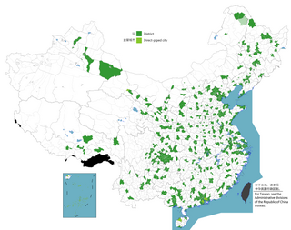
The term district, in the context of China, is used to refer to several unrelated political divisions in both ancient and modern China.
The administrative divisions of Peru have changed from time to time since the nation gained independence from Spain in the early 19th century. The old territorial subdivisions have split or merged due to several reasons, the most common ones being the need for decentralization and population increase, especially in Lima.

The districts of Peru are the third-level country subdivisions of Peru. They are subdivisions of the provinces, which in turn are subdivisions of the larger regions or departments. There are 1,838 districts in total.
Chinnavedampatti a suburb of Coimbatore City in the state of Tamil Nadu, India. It is located on the North-east direction, which comes under the Coimbatore Corporation.

Mapo District is one of the 25 districts of Seoul, South Korea. Mapo has a population of 381,330 (2015) and has a geographic area of 23.87 km2, and is divided into 24 dong. Mapo is located in western Seoul on the northern bank of the Han River, bordering the Gyeonggi Province city of Goyang to the northwest, and the Seoul city districts of Gangseo to the west, Yeongdeungpo to the south, Yongsan to the southeast, Jung to the east, and Seodaemun and Eunpyeong to the north.
Badli is a Village located in Rohini, North West District of Union Territory of Delhi, India. Three Metro Station are Nearly is Rohini Sector 18, 19 Metro Station, Haiderpur Badli Mor Metro Station and Samaypur Badli Metro Station.

The Coimbatore City Municipal Corporation is the civic body that governs the city of Coimbatore in the Indian state of Tamil Nadu. It is the second largest municipal corporation in Tamil Nadu after Chennai with an area of 257.04 sq km.

Semmedu is a Human settlement in Kollimalai Taluk, Namakkal district in the state of Tamil Nadu, India. It is the headquarter of the Kollihils block.
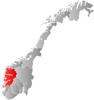
Vestland is a county in Norway. The county is located in Western Norway, and its administrative centre is Bergen, where the executive and political leadership is based. The County Governor is based in Hermansverk. Vestland is one of two counties in Norway that have Nynorsk as their official written language form.

