The Bois de Sioux River drains Lake Traverse, the southernmost body of water in the Hudson Bay watershed of North America. It is a tributary of the Red River of the North and defines part of the western border of the U.S. state of Minnesota, and the eastern borders of North Dakota and South Dakota. It is about 41 miles (66 km) in length.

The Little Minnesota River is a 71.4-mile-long (114.9 km) headwaters tributary of the Minnesota River in northeastern South Dakota and west-central Minnesota in the United States. Via the Minnesota River, it is part of the Mississippi River watershed.

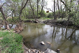
The Sunrise River is a 39.1-mile-long (62.9 km) tributary of the St. Croix River in east–central Minnesota in the United States. It originates within the boundaries of the Comfort Lake - Forest Lake Watershed District near the city of Forest Lake in Washington County. It's headwaters are considered several small tributaries that flow into and contribute to Forest Lake, the longest of which is the Washington Judicial Ditch 6. From the outflow from Forest Lake, the river flows north, accepting the South Branch from the west near the city of Wyoming, and continues north into Mud Lake, where the West Branch, which rises in southeast Isanti County and briefly enters Anoka County, joins it near the city of Stacy. From Stacy it flows generally north-northwest through Chisago County to meet the St. Croix River within Wild River State Park near the communities of Sunrise and Almelund. Not far upstream from its mouth, the Sunrise collects its North Branch, which rises in Isanti County and flows through the city of North Branch.
The Elk River is an 84.0-mile-long (135.2 km) river in east-central Minnesota in the United States. It is a tributary of the Mississippi River, draining a watershed of 630 square miles (1,600 km2).
The Snake River is a tributary of the Red River of the North in northwestern Minnesota in the United States. It is one of three streams in Minnesota with this name.
The Middle River is a tributary of the Snake River in northwestern Minnesota in the United States. It flows for its entire length in Marshall County.

The Wild Rice River is a tributary of the Red River of the North in northwestern Minnesota in the United States. It is 183 miles (295 km) long. Via the Red River, Lake Winnipeg and the Nelson River, it is part of the watershed of Hudson Bay. It is one of two Red River tributaries with the same name, the other being the Wild Rice River of North Dakota.
The Mustinka River is a tributary of Lake Traverse, 68 mi (109 km) long, in western Minnesota in the United States. Via Lake Traverse, the Bois de Sioux River, the Red River of the North, Lake Winnipeg, and the Nelson River, it is part of the watershed of Hudson Bay. The river drains an area of 909 square miles (2,350 km2).
Bachelor Lake is a lake in Brown County, Minnesota in the northeastern part of Stark township. Covering 79.80 acres, it is an officially protected water of the State of Minnesota. The lake is within the Cottonwood River Major Watershed. The lake’s elevation is 1,004 feet (306 m), and it is zoned as a shoreland area which is regulated as a shoreland management water.

The Vermilion River is a river in northern Ohio in the United States. It is 66.9 miles (107.7 km) long and is a tributary of Lake Erie, draining an area of 268 square miles (690 km2). The name alludes to the reddish clay that is the predominant local soil along its route. The river is commonly muddy after rains.
The Middle Fork of the Vermilion River is a tributary of the Vermilion River in Illinois. The Middle Fork rises in Ford County and flows southeast to join the Vermilion near Danville.

The Otter Tail River is a 192-mile-long (309 km) river in the west-central portion of the U.S. state of Minnesota. It begins in Becker County, 40 miles (64 km) southwest of Bemidji. It then flows through a number of lakes and cities in Minnesota, including Many Point Lake, Chippewa Lake, Height of Land Lake, Frazee, the Pine lakes, Rush Lake, Otter Tail Lake and Ottertail, West Lost Lake, Fergus Falls, and Orwell Lake.

The Sebasticook River is a 76-mile-long (122 km) river in the central part of Maine, in the United States. From its source in Dexter, the upper "Main Stream" section flows generally west and south 30 miles (48 km) to Great Moose Lake. From the outlet of the lake in Hartland, the Sebasticook flows 41 miles (66 km) south to the Kennebec River in Winslow.
Plum Creek is a 35.4-mile-long (57.0 km) stream near the city of Walnut Grove, Minnesota. It passes to the northwest of the town, flowing northeasterly to the Cottonwood River, with its waters then flowing to the Minnesota River and eventually the Mississippi River. Plum Creek lends its name to a regional library network.
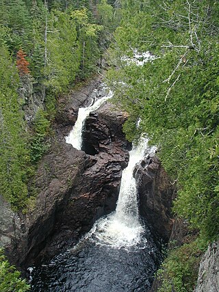
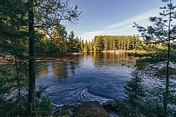
The Brule River is a river of the U.S. state of Minnesota. The Brule River originates at Vista Lake in the Boundary Waters Canoe Area Wilderness and flows 40.4 miles (65.0 km) east and southeast, terminating at Lake Superior approximately 14 mi (23 km) northeast of Grand Marais, Minnesota, within the boundaries of Judge C. R. Magney State Park. A major tributary is the South Brule River, which rises at the east end of Brule Lake in the Boundary Waters Canoe Area Wilderness
The Kelso River is a 4.0-mile-long (6.4 km) stream in northern Minnesota, the United States. It flows entirely within the Boundary Waters Canoe Area Wilderness of Superior National Forest, ending at Sawbill Lake. Water from the Kelso River flows via Sawbill Creek to the Temperance River and thence to Lake Superior.
The Rapid River is a 50 mi-long (80 km) river of Minnesota. It is a tributary of the Rainy River.
The Kabetogama State Forest is a state forest located in Koochiching and Saint Louis counties, Minnesota, United States. The forest borders the Superior National Forest and the Boundary Waters Canoe Area Wilderness to the east, the Sturgeon River State Forest to the south, the Nett Lake Indian Reservation to the west, and Voyageurs National Park to the north. The forest is managed by the Minnesota Department of Natural Resources.