Related Research Articles

Victoria Island is a large island in the Arctic Archipelago that straddles the boundary between Nunavut and the Northwest Territories of Canada. It is the eighth-largest island in the world, and at 217,291 km2 (83,897 sq mi) in area, it is Canada's second-largest island. It is nearly double the size of Newfoundland (111,390 km2 [43,010 sq mi]), and is slightly larger than the island of Great Britain (209,331 km2 [80,823 sq mi]) but smaller than Honshu (225,800 km2 [87,200 sq mi]). The western third of the island lies in the Inuvik Region of the Northwest Territories; the remainder is part of Nunavut's Kitikmeot Region. The population of 2,168 is divided among two settlements, the larger of which is in Nunavut and the other of which is in the Northwest Territories.
Butedale is a ghost town on Princess Royal Island, in British Columbia, Canada. It was founded in 1918 as a fishing, mining and logging camp. Initially the salmon cannery was established by Western Packers which was purchased and operated by the Canadian Fishing Company until it ceased operating in the 1950s. At its peak, Butedale's summertime population was over 400.

Princess Royal Island is the largest island on the North Coast of British Columbia, Canada. It is located amongst the isolated inlets and islands east of Hecate Strait on the British Columbia Coast. At 2,251 square kilometres (869 sq mi), it is the fourth largest island in British Columbia. It was named in 1788 by Captain Charles Duncan, after his ship Princess Royal.
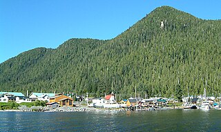
Hartley Bay is a First Nations community on the coast of British Columbia. The village is located at the mouth of Douglas Channel, about 630 kilometres (390 mi) north of Vancouver and 145 kilometres (90 mi) south of Prince Rupert. It is an isolated village accessible only by air and water with a population of 200.
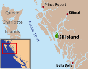
Gil Island is an island on the North Coast of British Columbia, Canada, located on the west side of Whale Channel in the entrance to Douglas Channel, one of the main coastal inlets, on the route of the Inside Passage between Pitt Island and Princess Royal Island. It is 26 km (16 mi) long, with a width ranging from 6 to 13 km, and an area of 231 km2. The only named summit on the mountainous island is Mount Gil, which faces the opening of Douglas Channel.

USAT Brigadier General M. G. Zalinski was a U.S. Army transport ship that served in World War II. It sank in 1946 in the Grenville Channel in British Columbia's Inside Passage. The crew were rescued by a tug boat and the SS Catala passenger steamer, but the cargo of bombs and oil went down with the ship.
Wright Sound is a waterway on the North Coast of British Columbia, Canada. Wright Sound is 135 kilometers (84 mi) south of Prince Rupert and lies at the southern opening of Grenville Channel and between Gil, Gribbell and Pitt Islands. The small town of Hartley Bay sits on its northern shore and is home to the Gitga'ata, a Tsimshian group. On the north side of Wright Sound develops the Douglas Channel.
Hawkesbury Island is an island in British Columbia, Canada. It is located in Douglas Channel, one of the major fjords of the British Columbia Coast. Hawkesbury is 43 kilometres (27 mi) long and ranges in width from 3 kilometres (1.9 mi) to 19 kilometres (12 mi). It covers an area of 365 square kilometres (141 sq mi).
The Estevan Group, formerly the Estevan Islands, is a small archipelago in the Hecate Strait region of the North Coast of British Columbia, Canada. It is to the west of Campania Island, which is separated from the group by Estevan Sound, and is itself to the west of Gil Island across Squally Channel. Southeast of it and of the Estevan Group is Caamaño Sound, beyond which is Aristazabal Island; to the east of all is Princess Royal Island, the fourth largest on the British Columbia Coast. To the northwest of the group is Banks Island.

Campania Island is an island on the coast of the Canadian province of British Columbia. It is located south of Prince Rupert, east across Hecate Strait from Haida Gwaii. To its west, across Estevan Sound, is the Estevan Group archipelago. Banks Island lies to the northwest, across Nepean Sound; and Pitt Island to the north, across Otter Channel. To the northeast, across Squally Channel, is Gil Island, and to the east is Princess Royal Island, across Campania Sound. To the south of Campania Island is Caamaño Sound, beyond which is Aristazabal Island.

Calvert Island is an island on the coast of the Canadian province of British Columbia. It is east of Queen Charlotte Sound in the Central Coast region, about 100 kilometres (62 mi) north of the town of Port Hardy, which is at the north end of Vancouver Island.
Hunter Island is an island on the coast of the Canadian province of British Columbia. It is located inshore from Queen Charlotte Sound, about 130 kilometres (81 mi) north of the town of Port Hardy at the north end of Vancouver Island.
Campania Sound is a sound on the North Coast of British Columbia, Canada, located between Campania Island and Princess Royal Island. It was named in association with Campania Island.

Lama Passage, sometimes referred to as Lama Pass, is a strait on the Central Coast of British Columbia, Canada, between Denny, Campbell and Hunter Islands. It is part of the Inside Passage shipping route, connecting Seaforth Channel with Fisher Channel. It was named for a Hudson's Bay Company brigantine, the Lama, under Captain McNeill, which with another HBC vessel, the Dryad under Captain Kipling, brought building materials and stores from Fort Vancouver for the founding of Fort McLoughlin in 1833.
Principe Channel is a strait on the North Coast of British Columbia, Canada, located between Banks Island (W) and Pitt Island (E). "Principe" means "prince" in Spanish.
Gribbell Island is an island on the North Coast of British Columbia, Canada, located on the east side of the entrance to Douglas Channel at Wright Sound. Gribble Island Indian Reserve No. 10 is on its west coast, between Verney Passage and Ursula Channel at 53°21′00″N129°08′00″W. The small Wimbledon Range is on the south side of the island, facing the northern extremities of Princess Royal Island to the south, at 53°21′00″N129°02′00″W
The Hartley Bay Indian Band is also known as the Gitga'at First Nation or the Hartley Bay First Nation. The members of the Gitga'at First nation are often referred to as Gitka'a'ata. The population of Gitk’a’ata peoples living in Hartley Bay ranges from approximately 130-200 people. There are also about 400-500 Gitk’a’ata peoples living in Prince Rupert, British Columbia, Canada, a neighboring territory. The Gitk’a’ata people have lived in Hartley Bay for hundreds of years, if not always. Some notable things regarding the Gitga'at First Nation are their economy, geography, government, sports involvement, COVID-19 regulations, and relations.
Kumealon Inlet is an inlet on the Coast of British Columbia, Canada. It lies on the eastern side of the north end of Grenville Channel facing Pitt Island.
Fin Island is an island in the North Coast region of British Columbia, Canada, to the northwest of Gil Island between Cridge and Lewis Passages.

Seaforth Channel is a channel in the Central Coast region of the Canadian province of British Columbia which is part of the Inside Passage - the 950 miles (1,530 km) passage between Seattle, Washington and Juneau, Alaska. The marine highway goes through Seaforth Channel on the way to Milbanke Sound, one of the open sea portions of the Inland Passage. Seaforth Channel which is part of the Prince Rupert/Port Hardy BC ferry route, extends in a westerly direction from Denny Island to Milbanke Sound between Denny Island, Campbell Island and the Wright group of islands on the south. In October 2016, a Texas-owned tug/barge transiting the Canadian waters of the Inside Passage without a local pilot was hard grounded on a reef at the entrance to Seaforth Channel in October 2016. More than 100,000 L of fuel contaminated the coast, coves and shores 20 km (12 mi) west of Bella Bella, the core community of the Heiltsuk Nation as well as the environmentally sensitive Great Bear Rainforest - Canada's contribution to the Queen's Commonwealth Canopy (QCC), a network of forest conservation programs. Clean up response and salvage was criticized by the Heiltsuk, B.C. Premier Christy Clark and Prime Minister Justin Trudeau. In November in Vancouver the Prime Minister announced a $1.5B ocean protection plan to "create a marine safety system, restore marine ecosystems and undertake research into oil spill cleanup methods."
References
- ↑ "Verney Passage". Geographical Names Data Base . Natural Resources Canada . Retrieved 2020-06-16.
- ↑ "Verney Passage". BC Geographical Names .
53°30′19″N129°04′23″W / 53.50528°N 129.07306°W
| | This article about a location on the North Coast of British Columbia, Canada is a stub. You can help Wikipedia by expanding it. |