
Traffic on roads consists of road users including pedestrians, ridden or herded animals, vehicles, streetcars, buses and other conveyances, either singly or together, while using the public way for purposes of travel.

An intelligent transportation system (ITS) is an advanced application which aims to provide innovative services relating to different modes of transport and traffic management and enable users to be better informed and make safer, more coordinated, and 'smarter' use of transport networks.

A ramp meter, ramp signal, or metering light is a device, usually a basic traffic light or a two-section signal light together with a signal controller, that regulates the flow of traffic entering freeways according to current traffic conditions. Ramp meters are used at freeway on-ramps to manage the rate of automobiles entering the freeway. Ramp metering systems have proved to be successful in decreasing traffic congestion and improving driver safety.

Traffic lights, traffic signals, stoplights or robots are signalling devices positioned at road intersections, pedestrian crossings, and other locations to control flows of traffic.

Traffic engineering is a branch of civil engineering that uses engineering techniques to achieve the safe and efficient movement of people and goods on roadways. It focuses mainly on research for safe and efficient traffic flow, such as road geometry, sidewalks and crosswalks, cycling infrastructure, traffic signs, road surface markings and traffic lights. Traffic engineering deals with the functional part of transportation system, except the infrastructures provided.
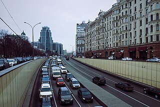
Traffic congestion is a condition in transport that is characterised by slower speeds, longer trip times, and increased vehicular queueing. Traffic congestion on urban road networks has increased substantially, since the 1950s. When traffic demand is great enough that the interaction between vehicles slows the speed of the traffic stream, this results in some congestion. While congestion is a possibility for any mode of transportation, this article will focus on automobile congestion on public roads.
Level of service (LOS) is a qualitative measure used to relate the quality of motor vehicle traffic service. LOS is used to analyze roadways and intersections by categorizing traffic flow and assigning quality levels of traffic based on performance measure like vehicle speed, density, congestion, etc. In a more general sense, levels of service can apply to all services in asset management domain.

A variable-message sign, often abbreviated VMS, CMS, or DMS, and in the UK known as a matrix sign, is an electronic traffic sign often used on roadways to give travellers information about special events. Such signs warn of traffic congestion, accidents, incidents such as terrorist attacks, AMBER/Silver/Blue Alerts, roadwork zones, or speed limits on a specific highway segment. In urban areas, VMS are used within parking guidance and information systems to guide drivers to available car parking spaces. They may also ask vehicles to take alternative routes, limit travel speed, warn of duration and location of the incidents, or just inform of the traffic conditions.
In mathematics and transportation engineering, traffic flow is the study of interactions between travellers and infrastructure, with the aim of understanding and developing an optimal transport network with efficient movement of traffic and minimal traffic congestion problems.
A junction is where two or more roads meet.
Access management, Access control. When used in traffic and traffic engineering circles, this generally refers to the regulation of interchanges, intersections, driveways and median openings to a roadway. Its objectives are to enable access to land uses while maintaining roadway safety and mobility through controlling access location, design, spacing and operation. This is particularly important for major roadways intended to provide efficient service to through-traffic movements.

A queue jump is a type of roadway geometry used to provide preference to buses at intersections, often found in bus rapid transit systems. It consists of an additional travel lane on the approach to a signalised intersection. This lane is often restricted to transit vehicles only. A queue jump lane is usually accompanied by a signal which provides a phase specifically for vehicles within the queue jump. Vehicles in the queue jump lane get a "head-start" over other queued vehicles and can therefore merge into the regular travel lanes immediately beyond the signal. The intent of the lane is to allow the higher-capacity vehicles to cut to the front of the queue, reducing the delay caused by the signal and improving the operational efficiency of the transit system.

The fundamental diagram of traffic flow is a diagram that gives a relation between the traffic flux (vehicles/hour) and the traffic density (vehicles/km). A macroscopic traffic model involving traffic flux, traffic density and velocity forms the basis of the fundamental diagram. It can be used to predict the capability of a road system, or its behaviour when applying inflow regulation or speed limits.

The geometric design of roads is the branch of highway engineering concerned with the positioning of the physical elements of the roadway according to standards and constraints. The basic objectives in geometric design are to optimize efficiency and safety while minimizing cost and environmental damage. Geometric design also affects an emerging fifth objective called "livability," which is defined as designing roads to foster broader community goals, including providing access to employment, schools, businesses and residences, accommodate a range of travel modes such as walking, bicycling, transit, and automobiles, and minimizing fuel use, emissions and environmental damage.

A traffic bottleneck is a localized disruption of vehicular traffic on a street, road, or highway. As opposed to a traffic jam, a bottleneck is a result of a specific physical condition, often the design of the road, badly timed traffic lights, or sharp curves. They can also be caused by temporary situations, such as vehicular accidents.

Traffic simulation or the simulation of transportation systems is the mathematical modeling of transportation systems through the application of computer software to better help plan, design, and operate transportation systems. Simulation of transportation systems started over forty years ago, and is an important area of discipline in traffic engineering and transportation planning today. Various national and local transportation agencies, academic institutions and consulting firms use simulation to aid in their management of transportation networks.

In traffic flow theory, the Newell–Daganzo merge model describes a simple procedure on how to determine the flows exiting two branch roadways and merging to flow through a single roadway. The model is simple in that it does not consider the actual merging process between vehicles as the two branch roadways come together. The only information required to calculate the flows leaving the two branch roadways are the capacities of the two branch roadways and the exiting capacity, the demands into the system, and a value describing how the two input flows interact. This latter input term is called the split priority, or merge ratio, and is defined as the proportion of the two input flows when both are operating in congested conditions.
Sidra Intersection is a software package used for intersection (junction) and network capacity, level of service and performance analysis, and signalised intersection and network timing calculations by traffic design, operations and planning professionals.

Terminology related to road transport—the transport of passengers or goods on paved routes between places—is diverse, with variation between dialects of English. There may also be regional differences within a single country, and some terms differ based on the side of the road traffic drives on. This glossary is an alphabetical listing of road transport terms.

A managed lane is a type of highway lane that is operated with a management scheme, such as lane use restrictions or variable tolling, to optimize traffic flow, vehicle throughput, or both. Definitions and goals vary among transport agencies, but managed lanes are generally implemented to achieve an improved operational condition on a highway, such as improving traffic speed and throughput, reducing air pollution, and improving safety. Types of managed lanes include High-occupancy vehicle (HOV) lanes, High-occupancy toll lanes, express toll lanes, reversible lanes, and bus lanes. Most managed lane facilities are located in the United States, although HOV and bus lanes can be found in many other countries; outside of the US, many countries use active traffic management that manage all lanes of a highway.
