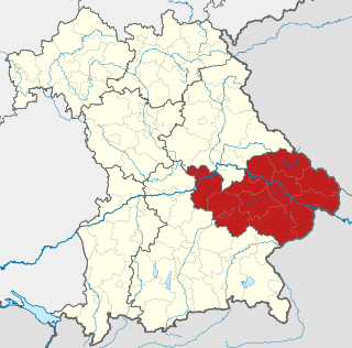
Kelheim is a Landkreis (district) in Bavaria, Germany, bound by the regions Regensburg, Landshut, Freising, Pfaffenhofen, Eichstätt and Neumarkt.
In most German states, the primary administrative subdivision is the Landkreis ; the exceptions are the states of North Rhine-Westphalia and Schleswig-Holstein, which use the term Kreis. Most major cities in Germany are not part of any Kreis, but instead themselves perform functions like those of the Kreise; such a city is referred to as a Kreisfreie Stadt or Stadtkreis.
Lower Bavaria is one of the seven administrative regions of Bavaria, Germany, located in the east of the state.
In Germany, a Verwaltungsgemeinschaft is an agreement or partnership between neighbouring municipalities (Gemeinde) of a district (Kreis) to co-operate on certain matters, e.g. planning, sanitation or education.
Municipalities are the lowest level of official territorial division in Germany. This is most commonly the third level of territorial division, ranking after the Land (state) and Kreis (district). The Gemeinde which is one level lower in those states also includes Regierungsbezirke as an intermediate territorial division. The Gemeinde is one level higher if it is not part of a Samtgemeinde. Only 10 municipalities in Germany have fifth level administrative subdivisions and all of them are in Bavaria. The highest degree of autonomy may be found in the Gemeinden which are not part of a Kreis. These Gemeinden are referred to as Kreisfreie Städte or Stadtkreise, sometimes translated as having "city status". This can be the case even for small municipalities. However, many smaller municipalities have lost this city status in various administrative reforms in the last 40 years when they were incorporated into a Kreis. In some states they retained a higher measure of autonomy than the other municipalities of the Kreis. Municipalities titled Stadt are urban municipalities while those titled Gemeinde are classified as rural municipalities.
Urban planning is a technical and political process concerned with the development and design of land use and the built environment, including air, water, and the infrastructure passing into and out of urban areas, such as transportation, communications, and distribution networks. Urban planning deals with physical layout of human settlements. The primary concern is the public welfare, which includes considerations of efficiency, sanitation, protection and use of the environment, as well as effects on social and economic activities. Urban planning is considered an interdisciplinary field that includes social, engineering and design sciences. It is closely related to the field of urban design and some urban planners provide designs for streets, parks, buildings and other urban areas. Urban planning is also referred to as urban and regional planning, regional planning, town planning, city planning, rural planning, urban development or some combination in various areas worldwide.
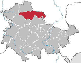
The Mainburg partnership is composed of the following municipalities:
The partnership is based in Mainburg, although the town itself is not a member of the partnership.
Mainburg is a town in the district of Kelheim, in Bavaria, Germany. It is situated on the river Abens, 30 km northwest of Landshut and 30 km southeast of Ingolstadt.
A geographic coordinate system is a coordinate system that enables every location on Earth to be specified by a set of numbers, letters or symbols. The coordinates are often chosen such that one of the numbers represents a vertical position and two or three of the numbers represent a horizontal position; alternatively, a geographic position may be expressed in a combined three-dimensional Cartesian vector. A common choice of coordinates is latitude, longitude and elevation. To specify a location on a plane requires a map projection.
Related Research Articles
The Kyffhäuserkreis is a district in the northern part of Thuringia, Germany. Neighboring districts are the districts Mansfeld-Südharz, Saalekreis und Burgenlandkreis in Saxony-Anhalt, and the districts Sömmerda, Unstrut-Hainich-Kreis and Eichsfeld.
Saale-Wipper is a Verbandsgemeinde in the district Salzlandkreis, in Saxony-Anhalt, Germany. Before 1 January 2010, it was a Verwaltungsgemeinschaft. It is situated southwest of Bernburg. It is named after the rivers Saale and Wipper, which flow through its territory. The seat of the Verbandsgemeinde is in Güsten.
Obere Aller is a Verbandsgemeinde in the Börde district in Saxony-Anhalt, Germany. Before 1 January 2010, it was a Verwaltungsgemeinschaft. It is situated approximately 30 km west of Magdeburg. It is named after the upper course of the river Aller, in its territory. The seat of the Verbandsgemeinde is in Eilsleben.
An der Finne is a Verbandsgemeinde in the Burgenlandkreis (district), in Saxony-Anhalt, Germany. Before the 1 July 2009 local government reform, it was a Verwaltungsgemeinschaft, covering the same area, but subdivided into more municipalities. It is named after the Finne, a range of hills between Lossa and Eckartsberga. It is situated approximately 20 km west of Naumburg, and 25 km northeast of Weimar. The seat of the Verwaltungsgemeinschaft is in Bad Bibra.
Biederitz-Möser was a Verwaltungsgemeinschaft in the Jerichower Land district, in Saxony-Anhalt, Germany. It was situated east of Magdeburg. The seat of the Verwaltungsgemeinschaft was in Möser. It was disbanded on 1 January 2010.
Möckern-Loburg-Fläming is a former Verwaltungsgemeinschaft in the Jerichower Land district, in Saxony-Anhalt, Germany. It is situated approximately 30 km east of Magdeburg. The seat of the Verwaltungsgemeinschaft was in Möckern. It was disbanded on 1 July 2012, when Schopsdorf joined the town of Genthin.
Oberes Geiseltal was a Verwaltungsgemeinschaft in the Saalekreis district, in Saxony-Anhalt, Germany. It was situated southwest of Halle (Saale). The seat of the Verwaltungsgemeinschaft was in Mücheln. It was disbanded on 1 January 2010.
Aiglsbach is a town and municipality in the Lower Bavarian district of Kelheim, Germany, and a member of the Mainburg administrative partnership, a voluntary resource-pooling agreement with three neighbouring municipalities.
Unstruttal is a Verbandsgemeinde in the Burgenlandkreis (district), in Saxony-Anhalt, Germany. Before 1 January 2010, it was a Verwaltungsgemeinschaft. It is situated along the river Unstrut, approx. 50 km west of Leipzig. The seat of the Verbandsgemeinde is in Freyburg.
Bernburg was a Verwaltungsgemeinschaft in the Salzlandkreis district, in Saxony-Anhalt, Germany. The seat of the Verwaltungsgemeinschaft was in Bernburg. It was disbanded on 1 January 2010.
Tangerhütte-Land was a Verwaltungsgemeinschaft in the district of Stendal, in Saxony-Anhalt, Germany. The seat of the Verwaltungsgemeinschaft was in Tangerhütte. It was disbanded in May 2010.
Wünschendorf/Elster is a Verwaltungsgemeinschaft in the district of Greiz, in Thuringia, Germany. The seat of the Verwaltungsgemeinschaft is in Wünschendorf/Elster.
Heldburger Unterland is a Verwaltungsgemeinschaft in the district of Hildburghausen, in Thuringia, Germany. The seat of the Verwaltungsgemeinschaft is in Heldburg.
Kindelbrück is a Verwaltungsgemeinschaft in the district of Sömmerda, in Thuringia, Germany. The seat of the Verwaltungsgemeinschaft is in Kindelbrück.
Hügelland/Täler is a Verwaltungsgemeinschaft in the district Saale-Holzland, in Thuringia, Germany. The seat of the Verwaltungsgemeinschaft is in Tröbnitz.
Südliches Saaletal is a Verwaltungsgemeinschaft in the district Saale-Holzland, in Thuringia, Germany. The seat of the Verwaltungsgemeinschaft is in Kahla, itself not part of the Verwaltungsgemeinschaft.
Oppurg is a Verwaltungsgemeinschaft in the district Saale-Orla-Kreis, in Thuringia, Germany. The seat of the Verwaltungsgemeinschaft is in Oppurg.
Ranis-Ziegenrück is a Verwaltungsgemeinschaft in the district Saale-Orla-Kreis, in Thuringia, Germany. The seat of the Verwaltungsgemeinschaft is in Ranis.
Schiefergebirge is a Verwaltungsgemeinschaft in the district Saalfeld-Rudolstadt, in Thuringia, Germany. It takes its name from the Thüringer Schiefergebirge. The seat of the Verwaltungsgemeinschaft is in Probstzella.
Dolmar-Salzbrücke is a Verwaltungsgemeinschaft in the district Schmalkalden-Meiningen, in Thuringia, Germany. The seat of the Verwaltungsgemeinschaft is in Schwarza. It was formed on 1 January 2012 from the former Verwaltungsgemeinschaften Dolmar and Salzbrücke.
This page is based on this Wikipedia article Text is available under the CC BY-SA 4.0 license; additional terms may apply. Images, videos and audio are available under their respective licenses.