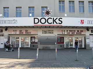
Docks is a nightclub located at Spielbudenplatz in the St. Pauli district of Hamburg, Germany. It has a capacity between 1,250 and 1,500 people. The building opened in 1900 as a cinema. Notable past performers include Bob Dylan, Black Sabbath, Motörhead, Ramones, Red Hot Chili Peppers, Def Leppard, Ozzy Osbourne, Dio, Iron Maiden, Nine Inch Nails and Liam Gallagher.
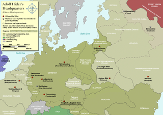
At the start of the Western European campaign of 1940, the Felsennest was the codename for one of Hitler's Führer Headquarters near Bad Münstereifel, Germany. It was much more cramped than Adolf Hitler's other field bunkers, having only four rooms. Hitler was at the Felsennest in the autumn of 1939, because there were plans to invade France and the Low Countries. He was there again on May 10, 1940 when the invasion took place.
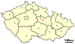
Leštinka is a small village in the Pardubice Region of the Czech Republic. It has around 140 inhabitants.

Kumpula is a verdant neighbourhood in Helsinki, bordered by Eastern Pasila to the west, Vallila to the south, Käpylä and Koskela to the north and Toukola and Arabianranta to the east. As of January 1, 2003, Kumpula had approximately 3,600 inhabitants.

The Borzeşti Power Station is a large thermal power plant located in Borzeşti, having 7 generation groups, 3 of 25 MW, 2 of 50 MW, 1 of 60 MW and 1 of 210 MW having a total electricity generation capacity of 655 MW.

Nurzyna is a village in the administrative district of Gmina Trzebieszów, within Łuków County, Lublin Voivodeship, in eastern Poland. It lies approximately 8 kilometres (5 mi) north-east of Łuków and 80 km (50 mi) north of the regional capital Lublin.
Zielona Ulica is a village in the administrative district of Gmina Biecz, within Gorlice County, Lesser Poland Voivodeship, in southern Poland. It lies approximately 6 kilometres (4 mi) north-west of Biecz, 14 km (9 mi) north of Gorlice, and 97 km (60 mi) east of the regional capital Kraków.
Wieprzec is a village in the administrative district of Gmina Maków Podhalański, within Sucha County, Lesser Poland Voivodeship, in southern Poland. It lies approximately 7 kilometres (4 mi) east of Maków Podhalański, 14 km (9 mi) east of Sucha Beskidzka, and 41 km (25 mi) south of the regional capital Kraków.
Skłody-Piotrowice is a village in the administrative district of Gmina Zaręby Kościelne, within Ostrów Mazowiecka County, Masovian Voivodeship, in east-central Poland.
Broczyna is a village in the administrative district of Gmina Trzebielino, within Bytów County, Pomeranian Voivodeship, in northern Poland. It lies approximately 10 kilometres (6 mi) south-west of Trzebielino, 35 km (22 mi) west of Bytów, and 112 km (70 mi) west of the regional capital Gdańsk.
Kornatka is a settlement in the administrative district of Gmina Smętowo Graniczne, within Starogard County, Pomeranian Voivodeship, in northern Poland. It lies approximately 5 kilometres (3 mi) north-west of Smętowo Graniczne, 23 km (14 mi) south of Starogard Gdański, and 67 km (42 mi) south of the regional capital Gdańsk.
Subkowy is a village in Tczew County, Pomeranian Voivodeship, in northern Poland. It is the seat of the gmina called Gmina Subkowy. It lies approximately 12 kilometres (7 mi) south of Tczew and 42 km (26 mi) south of the regional capital Gdańsk.
Czermnica is a village in the administrative district of Gmina Nowogard, within Goleniów County, West Pomeranian Voivodeship, in north-western Poland. It lies approximately 11 kilometres (7 mi) west of Nowogard, 20 km (12 mi) north-east of Goleniów, and 41 km (25 mi) north-east of the regional capital Szczecin.
Rozwarówko is a former settlement in the administrative district of Gmina Bobolice, within Koszalin County, West Pomeranian Voivodeship, in north-western Poland. As of 2010 it no longer figures in the national database of places.

Pind Sawikaand Bair Faqiran are towns in Jhelum District of Punjab, Pakistan. It is part of Jhelum Tehsil. It is located at the right bank of the Bunhar River and at starting of Tilla Jogian mountain range, where the Tilla Satellite Launch Center is located. As Geography these are two separate towns but economics situation is so different Bair Faqiran and Pind Swika. The Pind sawika is avail some facilities but Bair Faqiran town is with out all basic facilities. As per geography these two towns are need facilities.
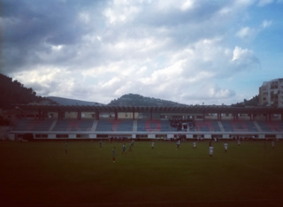
Tomori Stadium is a multi-use stadium in Berat, Albania. It is currently used mostly for football matches and is the home ground of Tomori. The stadium holds 17,890 people.

Mrkonje is a village in the municipality of Medveđa, Serbia. According to the 2002 census, the village has a population of 44 people.

Holijaci is a village in the municipality of Višegrad, Bosnia and Herzegovina.

Ballston Creek, also called Shenantaha Creek from the Iroquios name for Ballston Lake, is a stream in Saratoga County, New York. It originates at the north end of Ballston Lake and runs approximately six miles (9.7 km) through the towns of Ballston and Malta, descending 100 feet before exiting into Round Lake.


