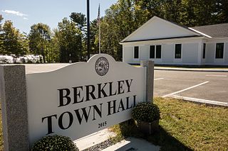
Berkley is a town in Bristol County, Massachusetts, United States, located south of Boston and east of Providence, Rhode Island. The population was 6,764 at the 2020 census, making it the least populated town in the county.

Dighton is a town in Bristol County, Massachusetts, United States. The population was 8,101 at the 2020 census. The town is located on the western shore of the Taunton River in the southeastern part of the state.
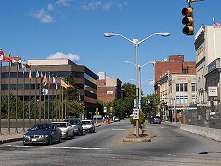
Fall River is a city in Bristol County, Massachusetts, United States. The City of Fall River's population was 94,000 at the 2020 United States Census, making it the tenth-largest city in the state.
Somerset is a town in Bristol County, Massachusetts, United States. The population was 18,303 at the 2020 census. It is the birthplace and hometown of Clifford Milburn Holland (1883–1924), the chief engineer and namesake of the Holland Tunnel in New York City.
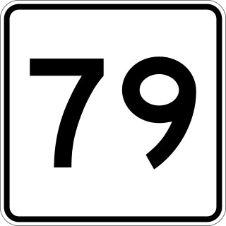
Route 79 is a 18.47-mile-long (29.72 km) state highway in southeastern Massachusetts. The route begins as a highway in Fall River also known as the Fall River Viaduct and Western Fall River Expressway before becoming a more rural route.
The Boise River Greenbelt is a recreational and alternate transportation trail along the banks of the Boise River through Boise, Idaho, United States. The Boise Greenbelt is more of a greenway than a green belt since its character is linear. It extends more than 20 miles (32 km) beginning at Lucky Peak Dam in the east to a short distance beyond Eagle Road in the west in Eagle, Idaho. Taking into account both sides of the river and other parallel trails and spurs, the total Greenbelt trail system measures more than 30 miles (48 km).

Interstate 195 (I-195) is an Interstate Highway running a combined 44.23 miles (71.18 km) in the US states of Rhode Island and Massachusetts. It travels from a junction with I-95 in Providence, Rhode Island, east to a junction with I-495 and Route 25 in Wareham, Massachusetts. It runs east–west and passes through the cities of Fall River, Massachusetts, and New Bedford, Massachusetts. The portion of I-195 in East Providence is also known as the East Providence Expressway.
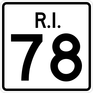
Route 78, also known as the Westerly Bypass, is a two-lane arterial boulevard and expressway between Pawcatuck, Connecticut to Westerly, Rhode Island. The route is about 4.6 miles (7.4 km) long and begins at Connecticut Route 2 in Stonington, crossing into Rhode Island at the Pawcatuck River, where it continues as an expressway to U.S. Route 1 in Westerly. The route was constructed in 1979, after a sixteen-year delay. The designation was to become part of the Orient Point–Watch Hill Bridge, but this plan was later dropped. The route was given the memorial name of Veterans Way in 2004.

The Mike O'Callaghan–Pat Tillman Memorial Bridge is an arch bridge in the United States that spans the Colorado River between the states of Arizona and Nevada. The bridge is located within the Lake Mead National Recreation Area approximately 30 miles (48 km) southeast of Las Vegas, and carries Interstate 11 and U.S. Route 93 over the Colorado River. Opened in 2010, it was the key component of the Hoover Dam Bypass project, which rerouted US 93 from its previous routing along the top of Hoover Dam and removed several hairpin turns and blind curves from the route. It is jointly named for Mike O'Callaghan, Governor of Nevada from 1971 to 1979, and Pat Tillman, an American football player who left his career with the Arizona Cardinals to enlist in the United States Army and was killed in Afghanistan in 2004 by friendly fire.

The fourth Berkley–Dighton Bridge is a four-span concrete arch bridge with closed spandrel walls of cast-in-place concrete, using pile-supported abutments and piers. The bridge was made such that it appears to be constructed of stone masonry rather than concrete. The two end spans are 74 feet and the two center spans are 92 feet for a total bridge length of approximately 350 feet.

The Cleveland Memorial Shoreway, often shortened to "the Shoreway", is a limited-access freeway in Cleveland and Bratenahl, Ohio. It closely follows the shore of Lake Erie and connects the east and west sides of Cleveland via the Main Avenue Bridge over the Cuyahoga River. The entire length of the Shoreway is part of the Lake Erie Circle Tour (LECT) and all but the very eastern end of the Shoreway is part of State Route 2. The Shoreway also carries parts of Interstate 90 and State Route 283 on its eastern side, and parts of U.S. Route 6 and U.S. Route 20 on its western side. The Cleveland neighborhood of Detroit-Shoreway is named after the two roads that form the northern border, the Shoreway and Detroit Avenue.
The Gold Star Memorial Bridge is a pair of steel truss bridges that carry both Interstate 95 and U.S. Route 1 across the Thames River between New London, Connecticut, US and Groton, Connecticut. The bridge is the largest structure in the state with more than 1,000,000 sq ft (93,000 m2) of deck area, and the longest bridge in the state at 6,000 feet (1,829 m). Its 11 highway lanes accommodate an average daily traffic of 117,000 vehicles. The bridge is actually a set of twin bridges, but they are generally spoken of using the singular "bridge;" the local media and residents refer to it as "The Goldstar".

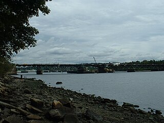
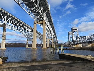
The Charles M. Braga Jr. Memorial Bridge, also known as the Braga Bridge, is a through truss bridge that carries Interstate 195 over the Taunton River between the town of Somerset and the city of Fall River, near the mouth of the Quequechan River at the confluence with Mount Hope Bay. At just over a mile long, it is one of the longest bridges in Massachusetts. Opened to traffic on April 15, 1966, it provides an important link between Providence, Rhode Island, New Bedford, and Cape Cod.
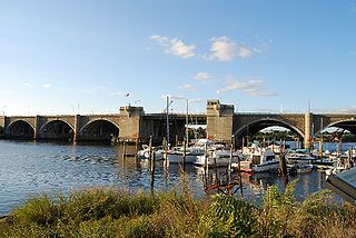
The Washington Bridge is a series of three bridges carrying Interstate 195, US Route 6, US Route 44, and U.S. Route 1A over the Seekonk River connecting India Point in Providence to Watchemoket Square in East Providence, Rhode Island. The historic portion of the bridge dating to 1930 serves as the pedestrian crossing, and bike link to the East Bay Bike Path. The pedestrian span is also a part of the Washington-Rochambeau National Historic Trail.
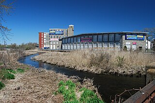
The Quequechan River is a river in Fall River, Massachusetts, that flows in a northwesterly direction from the northwest corner of the South Watuppa Pond through the heart of the city of Fall River and into the end of the Taunton River at Mount Hope Bay at Heritage State Park/Battleship Cove. The word Quequechan means "Falling River" or "Leaping/Falling Waters" in Wampanoag, hence the city's name.

The Brightman Street Bridge is a 922-foot (281 m) long, four-lane wide drawbridge spanning the Taunton River between the town of Somerset and the city of Fall River, Massachusetts. It was authorized in 1903 by the state legislature, and building took place between 1906 and 1908, when it opened full-time on October 10, 1908. It was closed to vehicular traffic on October 11, 2011.
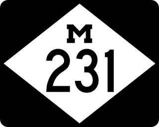
M-231 is the designation of a state trunkline highway in the Lower Peninsula of the US state of Michigan that serves as a partial bypass to US Highway 31 (US 31) around Grand Haven. This highway was built south of Interstate 96 (I-96) as an additional crossing over the Grand River. The route runs from M-45 northward and across the river to a connection with I-96 near the current M-104 interchange.

U.S. Route 6 (US 6) in Massachusetts is a 117.95 mi (189.83 km) long portion of the cross-country route connecting Providence, Rhode Island to Fall River, New Bedford, and Cape Cod. In the Fall River and New Bedford areas, US 6 parallels Interstate 195. On Cape Cod, US 6 is a highway interconnecting the towns of the area. The expressway section in this area is also known as the Mid-Cape Highway. The highway is also alternatively signed as the "Grand Army of the Republic Highway."

Mount Hope Bay is a tidal estuary located at the mouth of the Taunton River on the Massachusetts and Rhode Island border. It is an arm of Narragansett Bay. The bay is named after Mount Hope, a small hill located on its western shore in what is now Bristol, Rhode Island. It flows into the East Passage of Narragansett Bay and also the Sakonnet River. Mount Hope Bay has played an important role to the history of the area, from pre-colonial times to the present. While many years of sewage and industrial pollution have severely degraded the quality of the shallow waters of the bay, there are currently major efforts underway to clean up and restore it.
Brightman Street Bridge may refer to: