
Coeur d'Alene is a city and the county seat of Kootenai County, Idaho, United States. It is the largest city in North Idaho and the principal city of the Coeur d'Alene Metropolitan Statistical Area. In 2020, the United States Census Bureau estimated the city's population at 53,354. Coeur d'Alene is a satellite city of Spokane, which is located about thirty miles (50 km) to the west in the state of Washington. The two cities are the key components of the Spokane–Coeur d'Alene Combined Statistical Area, of which Coeur d'Alene is the third-largest city. The city is situated on the north shore of the 25-mile (40 km) long Lake Coeur d'Alene and to the west of the Coeur d'Alene Mountains. Locally, Coeur d'Alene is known as the "Lake City," or simply called by its initials, "CDA."

The Idaho Panhandle—locally known as North Idaho—is a salient region of the U.S. state of Idaho encompassing the state's 10 northernmost counties: Benewah, Bonner, Boundary, Clearwater, Idaho, Kootenai, Latah, Lewis, Nez Perce, and Shoshone. The Panhandle is bordered by the state of Washington to the west, Montana to the east, and the Canadian province of British Columbia to the north. The Idaho panhandle, along with Eastern Washington, comprises the region known as the Inland Northwest, headed by its largest city, Spokane, Washington.

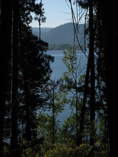
Lake Coeur d'Alene, officially Coeur d'Alene Lake, is a natural dam-controlled lake in North Idaho, located in the Pacific Northwest region of the United States. At its northern end is the city of Coeur d'Alene. It spans 25 miles (40 km) in length and ranges from 1 to 3 miles (5 km) wide with over 109 miles (175 km) of shoreline.
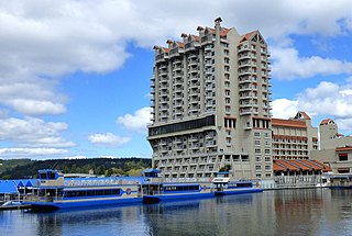
The Coeur d'Alene Resort is a luxury resort hotel in the northwest United States, located in Coeur d’Alene, Idaho. Seated on the north shore of Lake Coeur d'Alene by Tubbs Hill, the resort features a marina, convention facilities, spa, as well as a notable 18-hole golf course.

The Silver Valley is a region in the northwest United States, in the Coeur d'Alene Mountains in northern Idaho. It is noted for its mining heritage, dating back to the 1880s.

Lookout Pass is a mountain pass in the Rocky Mountains of the northwestern United States. In the Coeur d'Alene Mountains of the Bitterroot Range, the pass is on the border between Idaho and Montana, traversed by Interstate 90 at an elevation of 4,710 feet (1,436 m) above sea level.
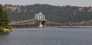
The Trail of the Coeur d'Alenes is a rail trail in the northwest United States, in northern Idaho. It follows the former Union Pacific Railroad right-of-way from Mullan, a mountain mining town near the Montana border, westward to Plummer, a town on the prairie near the Washington border. Generally following the Coeur d'Alene River, the rail line was abandoned in 1991 and the trail officially opened in March 2004.

Lookout Pass Ski and Recreation Area is a ski area in the western United States. It is at Lookout Pass on Interstate 90, on the border of Idaho and Montana, five miles (8 km) east of Mullan, Idaho. It has a summit elevation of 5,650 ft (1,720 m) on Runt Mountain with a vertical drop of 1,150 ft (350 m) on the northeast-facing slopes. Lookout Pass operates seven days per week from the beginning of the ski season until late March then six days a week until closing, which is usually mid-April.

Coeur d'Alene Airport / Pappy Boyington Field is a county-owned public-use airport, located in Kootenai County, Idaho, United States. It is located nine miles (14 km) northwest of the central business district of Coeur d'Alene and is surrounded by the city of Hayden on three sides.
Interstate 90 (I-90), designated as the American Veterans Memorial Highway, is a transcontinental Interstate Highway that runs from Seattle, Washington, to Boston, Massachusetts. It crosses Washington state from west to east, traveling 298 miles (480 km) from Seattle across the Cascade Mountains and into Eastern Washington, reaching the Idaho state line east of Spokane. I-90 intersects several of the state's other major highways, including I-5 in Seattle, I-82 and U.S. Route 97 (US 97) near Ellensburg, and US 395 and US 2 in Spokane.
Interstate 90 (I-90) is a transcontinental Interstate Highway that runs east–west across the northern United States. Within the state of Idaho, the freeway travels for 74 miles (119 km) from the Washington border near Spokane to Coeur d'Alene and the panhandle region at the north end of the state. After traveling through the Silver Valley along the Coeur d'Alene River in the Bitterroot Range, I-90 crosses into Montana at Lookout Pass.

Spokane, Washington has a rich sporting culture and the area residents are active in many spectator and participant sports. Although Spokane lacks any major, nationally recognized professional sports team, Spokane has a sports friendly atmosphere, and was recognized and rated #99 in the Sporting News 2006 "99 Best Sporting Cities" list. In 2009, Sports Business Journal rated Spokane as the fifth best minor league sports market in America out of 239 markets.
In the U.S. state of Idaho, U.S. Route 95 (US-95) is a north–south highway near the western border of the state, stretching from Oregon to British Columbia for over 538 miles (866 km); it was earlier known in the state as the North and South Highway.
Duane B. Hagadone was an American newspaper publisher, urban planner, real estate and land developer.

Coeur d’Alene High School is a four-year public secondary school in Coeur d'Alene, Idaho, one of two traditional high schools in the Coeur d'Alene School District #271. It serves the northeastern half of the district, with students from the cities of Coeur d'Alene, Dalton Gardens, Hayden, and a portion of unincorporated Kootenai County. The school colors are red, white and blue and the mascot is a Viking.
Heyburn State Park is a public recreation area in the U.S. state of Idaho. It is located almost entirely in Benewah County, with a small portion extending into southern Kootenai County. The park was founded in 1908 and is the oldest state or provincial park in the Pacific Northwest. The park has 5,744 acres (23.2 km2) of land and 2,332 acres (9.4 km2) of water on three lakes: Benewah, Chatcolet, and Hidden. A dam constructed on the Spokane River in Post Falls in 1906 raised the level of Lake Coeur d'Alene, connecting it to the park's three lakes. The surface elevation of the lakes is 2,125 feet (648 m) above sea level. The park's year-round recreational opportunities include camping, boating, hiking, horseback riding, fishing, and picnicking.
Interstate 90 Business may refer to several business routes of the Interstate Highway System that connects Interstate 90 with the central business district of various cities bypassed by I-90. Each business route can be either a business loop or a business spur, depending on whether both ends connect to I-90. The business route in each community is considered a unique route. In many cases, these routes are a former section of a U.S. Route.
Coeur d'Alene Parkway State Park is a 5.7-mile-long (9.2 km) paved trail in Kootenai County, Idaho, United States. The parkway is located south of Coeur d'Alene along the north shore of Lake Coeur d'Alene. It is a portion of the North Idaho Centennial Trail. Park features include a boat launch, docks, and picnic area at Higgens Point.
State Highway 97 (SH-97) is a state highway in Kootenai County, Idaho. The highway runs for 35.745 miles (57.526 km) from State Highway 3 to Interstate 90 (I-90) along the east side of Lake Coeur d'Alene, passing through the community of Harrison. The entire highway is designated as the Lake Coeur d'Alene Scenic Byway.
Jeanne Givens is an American politician who served in the Idaho House of Representatives from the 4th district as a member of the Democratic Party. She is a member of the Coeur d'Alene tribe and was the first Native American woman elected to the Idaho House of Representatives. Givens was also the first Native American woman to run for a seat in the United States Congress.

