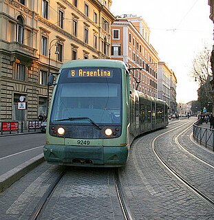
The street was built in the 1930s as a major route intended for the linking between Via Ostiense, the station of the Rome–Lido railway at Porta San Paolo and the Roma Ostiense railway station: it started from Piazza del Circo Massimo (now Piazza di Porta Capena) and ended in Via Marmorata. The first stretch of the street – giving a view over the Circus Maximus – houses the palace of the Food and Agriculture Organization (FAO), formerly built as the seat of the Ministry of the Colonies; for this reason, the first name of the street, adopted in 1938, was Viale Africa. At that time the urbanization of the surrounding area was just at its first steps, so the street had been conceived as an urban promenade, with large sidewalks, four rows of buttonwoods and a tram-line in the middle.
The former denomination was suppressed in 1945 and replaced with the present one. In 1955 the name of the last stretch, between Piazza Albania and Via Marmorata, was changed into Viale Manlio Gelsomini. The buttonwoods, which in the 1990s were infected by ceratocystis fimbriata, have been replaced at the beginning of the 2000s with lime trees and oaks.
Remains of the Servian Wall facing on Viale Aventino.
Viale della Piramide Cestia, that lengthen the street from Piazza Albania to Piazza di Porta San Paolo, cuts the circle of the Servian Wall, built during the Roman Republic: some remains are still visible in the surroundings of Piazza Albania.
Rendina, Claudio; Paradisi, Donatella (2004). Le strade di Roma. 1st Volume A-D. Rome: Newton Compton Editori. ISBN88-541-0208-3.
Related Research Articles
Ripa is the 12th rione of Rome, identified by the initials R. XII, and it is located in the Municipio I.
Castro Pretorio is the 18th rione of Rome (Italy), identified by the initials R. XVIII, and it is located within the Municipio I. The rione takes its name by the ruins of the Castrum Praetorium, the barracks of the Praetorian Guard, included in the Aurelian Walls.
Testaccio[teˈstattʃo] is the 20th rione of Rome, identified by the initials R. XX, deriving its name from Monte Testaccio. It is located within the Municipio I.
San Saba is the 21st rione of Rome, identified by the initials R. XXI. It is located within the Municipio I, and takes its name from the Basilica of San Saba, which is located there.
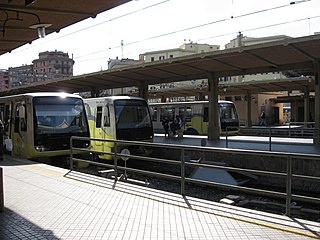
Piramide is a station on Line B of the Rome Metro. It was opened on 10 February 1955 and is sited on Piazzale Ostiense just outside Porta San Paolo, in the Ostiense quarter. Its atrium houses mosaics that have won the Artemetro Roma by Enrico Castellani (Italy) and Beverly Pepper. The station has escalators.
Roma Ostiense is a railway station in Piazza dei Partigiani serving the Ostiense district of Rome, Italy, a short distance from the Porta San Paolo. It is run by the Rete Ferroviaria Italiana arm of the Ferrovie dello Stato Italiane group and the urban rail lines FR1, FR3, and FR5 run through the station. It is linked with the Piramide Metro B station and the Roma Porta San Paolo station on the Rome-Lido railway line.
Basilica San Paolo is a station on the Line B of the Rome Metro. It was opened in 1955 and is located at the intersection between Viale Giustiniano Imperatore and Via Gaspare Gozzi, behind the Basilica of Saint Paul Outside the Walls in the Ostiense quarter. It is also one of three Metro stations also served by the Rome-Lido railway line.
Roma Porta San Paolo is the terminal train station of the Rome–Lido railway line in Rome (Italy). The station is connected to the station Piramide of the metro and to the Roma Ostiense railway station of the Ferrovie dello Stato Italiane. It has six tracks.
The current tram system in Rome, Italy, is a leftover from what once was the largest tram system in Italy. With its fragmented structure, it does not currently function as a backbone of the city's public transport. The system is owned and operated by Azienda Tranvie e Autobus del Comune di Roma.
Via Cristoforo Colombo is a street in Rome (Italy) that links the historic centre to Ostia. Along most of its route, the street has three lanes for each direction of movement. With its 27 kilometres (17 mi) length it is the longest Italian road among those included within the borders of a single municipality and, in several stretches, the largest in Italy.
Ostiense is the 10th quartiere of Rome, identified by the initials Q. X.
ATAC S.p.A. is an Italian publicly owned company running most of the local public transportation services, paid parking and incentive parking lots in Rome. More specifically, the company handles, on behalf of Roma Capitale Authority, the entire tramway, trolleybus network and metro lines, as well as most of the bus lines in the city. It also operates, on behalf of the Administrative Region of Lazio, three railways: Roma-Civita Castellana-Viterbo, Roma-Giardinetti and Roma-Lido. ATAC S.p.A., with its 2,200-kilometer-wide public transport network, its over 8,500 busses and 70,000 parking stalls, is currently one of the biggest public transportation companies in Europe and the largest in Italy.
Lungotevere is an alley or boulevard running along the river Tiber within the city of Rome. The building of the Lungoteveres required the demolition of the former edifices along the river banks and the construction of retaining walls called muraglioni.
Portuense is the 11th quartiere of Rome (Italy), identified by the initials Q.XI.
Lungotevere Dante is the stretch of lungotevere linking Viale Guglielmo Marconi with Ponte Marconi, in Rome, in the Ostiense district.
Lungotevere di San Paolo is the stretch of Lungotevere that connects via Ostiense to Piazza Tommaso Edison, in Rome, in the Ostiense district.
Pinciano is the 3rd quartiere of Rome (Italy), identified by the initials Q. III. The name derives from the Pincian Hill. It belongs to the Municipio II.
Salario is the 4th quarter of Rome (Italy), identified with the initials Q. IV.
Trieste is the 17th quarter of Rome (Italy), identified by the initials Q. XVII.
Corso di Francia, informally called Corso Francia, is a street in the northern area of Rome (Italy). It runs in a south–north direction between the Quarters Parioli and Tor di Quinto and, together with the nearby Via del Foro Italico and Viale Guglielmo Marconi, is the only urban road in the town to overpass the Tiber keeping the same name on both banks.
This page is based on this Wikipedia article Text is available under the CC BY-SA 4.0 license; additional terms may apply. Images, videos and audio are available under their respective licenses.