
Contra Costa County is located in the state of California in the United States. As of the 2020 census, the population was 1,165,927. The county seat is Martinez. It occupies the northern portion of the East Bay region of the San Francisco Bay Area, and is primarily suburban. The county's name refers to its position on the other side of the bay from San Francisco. Contra Costa County is included in the San Francisco–Oakland–Berkeley, CA Metropolitan Statistical Area.

Martinez is a city and the county seat of Contra Costa County, California, in the East Bay region of the San Francisco Bay Area. The population was 38,290 at the 2020 census. The city is named after Californio ranchero Ygnacio Martínez. The downtown is notable for its large number of preserved old buildings and antique shops. Martinez is located on the southern shore of the Carquinez Strait in the San Francisco Bay Area, directly facing the city center of Benicia and the southeastern end of Vallejo, California.

The John Muir National Historic Site is located in the San Francisco Bay Area, in Martinez, Contra Costa County, California. It preserves the 14-room Italianate Victorian mansion where the naturalist and writer John Muir lived, as well as a nearby 325-acre tract of native oak woodlands and grasslands historically owned by the Muir family. The main site is on the edge of town, in the shadow of State Route 4, also known as the "John Muir Parkway."

West County Detention Center is a large coeducational adult medium security Contra Costa County jail in Richmond, California opened in 1991.

Carquinez Strait Regional Shoreline is a regional park, part of the East Bay Regional Park District system, located in northwestern Contra Costa County, California.

Pinole Creek is a stream in western Contra Costa County, in the East Bay region of the San Francisco Bay Area, California.

Alhambra Creek is a stream in Contra Costa County, in the East Bay region of the San Francisco Bay Area in northern California.
Monterey Colonial is an architectural style developed in Alta California. Although usually categorized as a sub-style of Spanish Colonial style, the Monterey style is native to the post-colonial Mexican era of Alta California. Creators of the Monterey style were mostly recent immigrants from New England states of the US, who brought familiar vernacular building styles and methods with them to California.
Giant was an unincorporated community, now within Point Pinole Regional Shoreline, and annexed to Richmond in Contra Costa County, California. It lies at an elevation of 23 feet.
Rancho Laguna de Los Palos Colorados was a 13,316-acre (53.89 km2) Mexican land grant in the Berkeley Hills within present-day Contra Costa County, California.
Rancho El Pinole was a 17,761-acre (71.88 km2) Mexican land grant along Carquinez Strait in present-day Contra Costa County, California.
Rancho Boca de la Cañada del Pinole was a 13,316-acre (53.89 km2) Mexican land grant in present-day Contra Costa County, California given in 1842 by Governor Juan Alvarado to María Manuela Valencia. The name means "Mouth of the Pinole Valley" in Spanish. The rancho located between present-day Martinez, Pleasant Hill, Orinda, and Lafayette.
Rancho Cañada del Hambre y Las Bolsas was a 13,354-acre (54.04 km2) Mexican land grant in present day northwestern Contra Costa County, California.
Rancho Las Juntas was a 13,293-acre (53.79 km2) Mexican land grant in present day Contra Costa County, California given in 1844 by Governor Manuel Micheltorena to William Welch. The name Las Juntas translates as "the Crossroads". The grant was located between Ygnacio Martinez’ Rancho El Pinole and Salvio Pacheco’s Rancho Monte del Diablo, and included northwestern Walnut Creek, all of Pleasant Hill, and the eastern portion of Martinez. The original borders of the claim were defined as the straits to the north, "Las Juntas" to the south, the Walnut creek to the east, the Reliz ridge to the west, and, to the northwest, the Alhambra creek.

The Don Fernando Pacheco Adobe is located at 3119 Grant Street in Concord, California.The Fernando Pacheco Adobe is the only Concord landmark listed in all three Historical Registries: entry on the National Register occurred on June 6, 1980; the California Registered landmark number is 455; and the Concord Historical Landmark designation is 1-26-26/5458. The Adobe was built by Don Fernando in the early 1850s as the base of operations for his growing ranch activities, and as his family's formal residence. Fernando was the oldest son of Don Salvio Pacheco. He was born on May 30, 1818, while his father was assigned to a Militia-Guard unit at the Pueblo of San Jose. At age 17, he was sent to take possession and mark the boundaries of his father's 17,921 acre land grant. Fernando was given 1,500 acres as initial share of the rancho. He subsequently married Pasquala (Figeroa) (Juarez) – a widow. Their six children: Pedro, Bonifacio, Cipriana, Maria Asuncion, Librada and Bersabe were raised at the Adobe. Don Fernando's family enjoyed a reputation as gracious hosts. They were famous for their generosity and extensive fiestas on Adobe's then lush, well irrigated grounds. The Adobe's 32” thick walls were built of local adobe – mud.

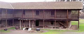
The Moraga Adobe is located at 24 Adobe Lane in Orinda, California. It was built by Don Joaquin Moraga who was the grandson of Jose Joaquin Moraga an early Spanish explorer in California who founded the city of San Jose, California. In 1835, Mexico granted 13,326 acres (5,393 ha), El Rancho Laguna de los Palos Colorados, to Joaquin Moraga and his cousin Juan Bernal. Six years later in 1841, Joaquin built this house, which is the oldest of the five surviving adobe houses in Contra Costa County. The adobe sits on a knoll at the center of the 20-acre (8.1 ha) property of what is left of the original land grant. The house has been restored and remodeled twice since it was photographed for HABS, first in 1941 when Katharine Brown White Irvine of Oakland, California purchased the old adobe, making additions such as adding three bedrooms and a veranda, and covering the adobe walls and again in 1964 when it was incorporated into a private home. The house is not accessible to the public and it is fenced off. However, it was photographed in 1922 for the Historical American Building Survey (HABS). Today, the Moraga Adobe is privately owned and unoccupied. The overall condition of the original adobe section and the more modern addition is neglected, but the building appears sound. The surrounding property was recently purchased, and the new owners have boarded up the windows to prevent vandalism and trespassing. The Moraga Adobe has been designated as a Historical Landmark by the City of Orinda and the State of California. A campaign has been started to purchase the property and restore the house to its 1848 configuration, to be used as a museum and educational site.

Marsh Creek State Historic Park is a California state park in east Contra Costa County, California, United States. It was named as the newest California State Park on January 27, 2012. The newly named park contains 3,659 acres and is about 3.3 miles (5.3 km) south of downtown Brentwood.
Bernardo Fernandez was an early pioneer of western Contra Costa County, California in the United States of America.
The Giant Powder Company was an explosives manufacturing company which operated from the mid 19th century through the first half of the 20th century, located in the San Francisco Bay Area of California. The Giant Powder Company was the first company in the United States to produce dynamite under an exclusive license from Alfred Nobel.
Louis Lorenz Stein Jr., often referred to as Louie, was an American pharmacist, California East Bay historian and archivist. He was best known for founding the Arlington Pharmacy in Kensington, California, the Pharmacy Museum at Columbia State Historic Park and donating his collection of historical materials to the Contra Costa County Historical Society.
