
Leicester is a city, unitary authority area, unparished area and the county town of Leicestershire in the East Midlands of England. It is the largest city in the East Midlands. Its population was 368,600 in 2021, increased by 38,800 from around 329,800 in 2011. The greater Leicester urban area had a population of 559,017 in 2021, making it the 11th most populous in England, and the 13th most populous in the United Kingdom.

Hyde Park is a 350 acres (140 ha), historic Grade I-listed urban park in Westminster, Greater London. A Royal Park, it is the largest of the parks and green spaces that form a chain from Kensington Palace through Kensington Gardens and Hyde Park, via Hyde Park Corner and Green Park, past Buckingham Palace to St James's Park. Hyde Park is divided by the Serpentine and the Long Water lakes.

Oadby and Wigston is a local government district and borough in the county of Leicestershire, England. It was formed in 1974, under the Local Government Act 1972, from the merger of the Oadby and Wigston urban districts. The population of the district at the 2011 census was 56,170. The district forms part of the Harborough constituency.

The Tower Hill Memorial is a pair of Commonwealth War Graves Commission memorials in Trinity Square Gardens, on Tower Hill in London, England. The memorials, one for the First World War and one for the Second, commemorate civilian, merchant seafarers and fishermen who were killed as a result of enemy action and have no known grave. The first, the Mercantile Marine War Memorial, was designed by Sir Edwin Lutyens and unveiled in 1928; the second, the Merchant Seamen's Memorial, was designed by Sir Edward Maufe and unveiled in 1955. A third memorial, commemorating merchant seamen who were killed in the 1982 Falklands War, was added to the site in 2005.

Oadby is a town in the borough of Oadby and Wigston in Leicestershire, England. Oadby is a district centre 4 miles (6.4 km) south-east of Leicester on the A6 road. Leicester Racecourse is situated on the border between Oadby and Stoneygate. The University of Leicester Botanical Garden is in Oadby. Oadby had a population of 23,849 in 2011, and like its neighbour Wigston is made up of five wards. The Borough of Oadby and Wigston is twinned with Maromme in France, and Norderstedt in Germany.

Victoria Park is a park in the London Borough of Tower Hamlets in East London, England.
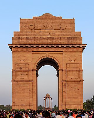
The India Gate is a war memorial located near the Kartavya path on the eastern edge of the "ceremonial axis" of New Delhi, formerly called Rajpath. It stands as a memorial to 84,000 soldiers of the Indian Army who died between 1914 and 1921 in the First World War, in France, Flanders, Mesopotamia, Persia, East Africa, Gallipoli and elsewhere in the Near and the Far East, and the Third Anglo-Afghan War. 13,300 servicemen's names, including some soldiers and officers from the United Kingdom, are inscribed on the gate. Designed by Sir Edwin Lutyens, the gate evokes the architectural style of the ancient Roman triumphal arches such as the Arch of Constantine in Rome, and later memorial arches; it is often compared to the Arc de Triomphe in Paris, and the Gateway of India in Mumbai.

Avenham Park is a public park in Avenham, close to the centre of Preston in Lancashire in the northwest of England, and managed by Preston City Council.

Melbourne Showgrounds is located in the inner north-western suburb of Ascot Vale, Victoria, Australia, next door to Flemington Racecourse. The largest and most flexible indoor/outdoor venue space in Melbourne the Showgrounds is the home of the annual Melbourne Royal Show, as well as major exhibitions, trade shows, and music concerts, including the Supanova Pop Culture Expo, the Caravan & Camping Touring Supershow and MotoExpo.
Leicester Racecourse is a horse racing course in Oadby, Leicestershire, about three miles south of the city centre.

Glen Parva is a civil parish in the Blaby district of Leicestershire, England with a population of over 17,000. The population of the civil parish, including Eyres Monsell was 17,189 in the 2011 census. To the north it runs into Aylestone and to the east South Wigston. To the south and west it is not immediately surrounded by development.

The A563 is the designation for the ring road of Leicester, England. It forms a near-complete circuit except for a gap of around 2.2 miles (3.5 km) in the east of the city. An indirect route linking the gap involves the (A47) A6030, and A6. The A563 was formerly referred to as the Outer Ring.

Endcliffe Park is a large park in the city of Sheffield, South Yorkshire, England. The park was opened in 1887 to commemorate the Jubilee of Queen Victoria. When travelling West from the city centre it is the first in a series of parks and green spaces, known collectively as the Porter Valley Parks, all of which lie along the course of the Porter Brook. The next park in the sequence is Bingham Park, separated from Endcliffe Park by Rustlings Road. In 1924 Patrick Abercrombie said of the parks, "The Porter Brook Parkway, consisting as it does of a string of contiguous open spaces, is the finest example to be found in this country of a radial park strip, an elongated open space, leading from a built-up part of the city direct into the country, the land occupied being a river valley and so for the greater part unsuitable for building."
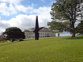
The Auckland Domain, also known as Pukekawa / Auckland Domain, is a large park in Auckland, New Zealand. It is the oldest park in the city, and at 75 hectares is one of the largest. Located in the central suburb of Grafton, the park land is the remains of the explosion crater and most of the surrounding tuff ring of the Pukekawa volcano.

The Memorial Gates are a war memorial located at the Hyde Park Corner end of Constitution Hill in London. Also known as the Commonwealth Memorial Gates, they commemorate the soldiers of the British Empire from five countries of the Indian subcontinent, as well as Africa and the Caribbean, who served for Britain in the First and Second World Wars.

Alexandra Park Racecourse, known to Londoners as Ally Pally, was a horse racing venue in Alexandra Park, London, England; it was colloquially known as the Frying Pan on account of its shape. It opened on 30 June 1868 and closed 102 years later on 8 September 1970. It is now incorporated into the park, with a sports pitch in the centre of the racetrack oval.
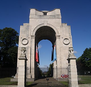
The Arch of Remembrance is a First World War memorial designed by Sir Edwin Lutyens and located in Victoria Park, Leicester, in the East Midlands of England. Leicester's industry contributed significantly to the British war effort. A temporary war memorial was erected in 1917, and a committee was formed in 1919 to propose a permanent memorial. The committee resolved to appoint Lutyens as architect and to site the memorial in Victoria Park. Lutyens's first proposal was accepted by the committee but was scaled back and eventually cancelled due to a shortage of funds. The committee then asked Lutyens to design a memorial arch, which he presented to a public meeting in 1923.
Spalding War Memorial is a First World War memorial in the gardens of Ayscoughfee Hall in Spalding, Lincolnshire, in eastern England. It was designed by the architect Sir Edwin Lutyens. The proposal for a memorial to Spalding's war dead originated in January 1918 with Barbara McLaren, whose husband and the town's Member of Parliament, Francis McLaren, was killed in a flying accident during the war. She engaged Lutyens via a family connection and the architect produced a plan for a grand memorial cloister surrounding a circular pond, in the middle of which would be a cross. The memorial was to be built in the formal gardens of Ayscoughfee Hall, which was owned by the local district council. When McLaren approached the council with her proposal, it generated considerable debate within the community and several alternative schemes were suggested. After a public meeting and a vote in 1919, a reduced-scale version of McLaren's proposal emerged as the preferred option, in conjunction with a clock on the town's corn exchange building.


