The Nakusp and Slocan Railway (N&S) is a historic Canadian railway that operated in the West Kootenay region of southeastern British Columbia. The N&S initially connected Nakusp and Three Forks but soon extended to Sandon.
Princeton is a town municipality in the Similkameen area of southern British Columbia, Canada. The former mining and railway hub lies at the confluence of the Tulameen into the Similkameen River, just east of the Cascade Mountains. It is at the junction of BC Highway 3 and 5A.
Hedley is an unincorporated community near the mouth of Hedley Creek in the Similkameen region of southern British Columbia. The former mining town, on BC Highway 3, is by road about 74 kilometres (46 mi) southwest of Penticton and 38 kilometres (24 mi) southeast of Princeton.

Ashcroft is a village municipality that straddles the Thompson River in the Thompson Country region of south central British Columbia, Canada. East of BC Highway 1 and on BC Highway 97C, the locality is by road about 45 kilometres (28 mi) north of Spences Bridge and 11 kilometres (7 mi) south of Cache Creek.
Eholt is in the Boundary Country region of south central British Columbia. This ghost town, on BC Highway 3, is by road about 27 kilometres (17 mi) northwest of Grand Forks and 14 kilometres (9 mi) northeast of Greenwood.

Ymir is a village in the Selkirk Mountains in the West Kootenay region of southeastern British Columbia. Ymir is located where the Salmo River meets Quartz Creek, and Ymir Creek. The locality, on BC Highway 6, is by road about 10 kilometres (6 mi) northeast of Salmo and 34 kilometres (21 mi) south of Nelson.
Kitselas is a railway point on the northwestern shore of the Skeena River in the Skeena region of west central British Columbia, Canada. The former name was Vanarsdol. Across the Skeena to the southwest is the mouth of the Zymoetz River. This river bridge on BC Highway 16 is by road about 10 kilometres (6 mi) northeast of Terrace.
Baynes Lake is an unincorporated rural community on the east shore of Lake Koocanusa, just north of the mouth of the Elk River, in the East Kootenay region of southeastern British Columbia. Off BC Highway 93, the locality is by road about 65 kilometres (40 mi) southEAST of Cranbrook and 44 kilometres (27 mi) southWEST of Fernie.
Chopaka is an unincorporated community in the Similkameen region of south central British Columbia. Immediately north of the Canada–United States border, the population centre is on the west shore of the Similkameen River. The Nighthawk–Chopaka Border Crossing lies to the east. Off BC Highway 3, the locality is by road about 96 kilometres (60 mi) southeast of Princeton and 75 kilometres (47 mi) south of Penticton.

Hope station is a Via Rail flag stop at Hope in southwestern British Columbia, Canada. Formerly, a Canadian National Railway (CN) station stood at this location and a Kettle Valley Railway (KV) one to the northwest.
Waldo is a ghost town in the East Kootenay region of southeastern British Columbia. About 2 kilometres (1.2 mi) north of Krag, the remnants are submerged beside the east shore of Lake Koocanusa, just north of the mouth of the Elk River. Off BC Highway 93, the site is by road about 69 kilometres (43 mi) southwest of Cranbrook and 48 kilometres (30 mi) southeast of Fernie.
The Victoria and Sidney Railway Company (V&S) was one of three railways to operate on the Saanich Peninsula of southern Vancouver Island, British Columbia. Opened in 1894 the route largely closed in 1919 but a section of track remained in use until 1935.
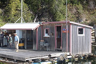
Kildonan is an unincorporated community in the Alberni Inlet-Barkley Sound region of the west coast of southern Vancouver Island, British Columbia. The former steamboat landing and ferry dock is on the east shore of Uchuchklesit Inlet, which branches northwest of the lower reaches of Alberni Inlet. Adjacent to Pacific Rim National Park Reserve, the locality is by road and ferry about 120 kilometres (75 mi) southwest of Port Alberni.

The Danville–Carson Border Crossing connects the town of Danville, Washington with Grand Forks, British Columbia on the Canada–US border. Washington State Route 21 on the American side joins British Columbia Highway 41 on the Canadian side.

The Porthill-Rykerts Border Crossing connects the town of Bonners Ferry, Idaho with Creston, British Columbia on the Canada–US border. Idaho State Highway 1 on the American side joins British Columbia Highway 21 on the Canadian side, which continues north towards Creston. The Porthill-Rykerts Border Crossing is used as the American Port only; Rykerts acts as the Canadian Crossing.
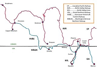
The Vancouver, Victoria and Eastern Railway (VV&E) was a railway line proposed to connect Metro Vancouver with the Kootenays, in Canada. After acquisition by the Great Northern Railway (GN), most of the route was built, but a passenger through service, using the arranged running rights on the tracks of other companies, never transpired.

The Ladner Ferry was a crossing of the south arm of the Fraser River in Metro Vancouver, linking Ladner with Richmond. It operated from 1913 until 1959, when it was replaced by the George Massey Tunnel.

The Spokane Falls & Northern (SF&N) is a historic railroad that operated in northeast Washington state. The SF&N initially connected the city of Spokane with the Canada–United States border at Waneta, British Columbia.
The Bulldog Tunnel, which carried the former Canadian Pacific Railway (CP) southern main line under Bulldog Mountain, is in the West Kootenay region of southeastern British Columbia. By rail, the tunnel was 71.3 kilometres (44.3 mi) northeast of Grand Forks, and 39.8 kilometres (24.7 mi) west of Castlegar.
Twelve Mile was a railway point in the West Kootenay region of southeastern British Columbia. The scattered community straddled the shores of the Columbia River. The locality, off BC Highway 23, is by road about 24 kilometres (15 mi) southeast of Revelstoke.
