Saint Lucia is an island country of the West Indies in the eastern Caribbean. The island was previously called Iouanalao and later Hewanorra, names given by the native Arawaks and Caribs (respectively), two Amerindian peoples. Part of the Windward Islands of the Lesser Antilles, it is located north/northeast of the island of Saint Vincent, northwest of Barbados and south of Martinique. It covers a land area of 617 km2 with an estimated population of over 180,000 people as of 2018. The nation's capital and largest city is Castries.

Saint Lucia was inhabited by the Arawak and Kalinago Caribs before European contact in the early 16th century. It was colonized by the British and French in the 17th century and was the subject of several possession changes until 1814, when it was ceded to the British by France for the final time. In 1958, St. Lucia joined the short-lived semi-autonomous West Indies Federation. Saint Lucia was an associated state of the United Kingdom from 1967 to 1979 and then gained full independence on February 22, 1979.

Basseterre is the capital and largest city of Saint Kitts and Nevis with an estimated population of 14,000 in 2018. Geographically, the Basseterre port is located at 17°18′N62°44′W, on the south western coast of Saint Kitts Island, and it is one of the chief commercial depots of the Leeward Islands. The city lies within Saint George Basseterre Parish.

Castries is the capital and largest city of Saint Lucia, an island country in the Caribbean. The urban area has a population of approximately 20,000, while the eponymous district has a population of 70,000, as at May 2013. The city covers 80 km2 (31 sq mi).

Port of Spain, officially the City of Port of Spain, is the capital of Trinidad and Tobago and the third largest municipality, after Chaguanas and San Fernando. The city has a municipal population of 37,074 (2011), an urban population of 81,142 and a transient daily population of 250,000. It is located on the Gulf of Paria, on the northwest coast of the island of Trinidad and is part of a larger conurbation stretching from Chaguaramas in the west to Arima in the east with an estimated population of 600,000.

St. Lucie County is a county located in the southeastern portion of the U.S. state of Florida. As of the 2020 census, the population was 329,226. The county's seat is Fort Pierce, while the largest city is Port St. Lucie, making up 62% of the county's population. St. Lucie County is the principal county of the Port St. Lucie, FL Metropolitan Statistical Area.

St. Marys is a city in Camden County, Georgia, United States, located on the southern border of Camden County on the St. Marys River in the state's Low Country. It had a population of 18,256 at the 2020 census, up from 17,121 at the 2010 census. It is part of the Kingsland, Georgia Micropolitan Statistical Area. The Florida border is just to the south across the river, Cumberland Island National Seashore is to the northeast, and Kingsland, Georgia, is to the west. Jacksonville, Florida, is 38 miles south, and Savannah, Georgia, is 110 miles north.

Hewanorra International Airport, located near Vieux Fort Quarter, Saint Lucia, in the Caribbean, is the larger of Saint Lucia's two airports and is managed by the Saint Lucia Air and Seaports Authority (SLASPA). It is on the southern cape of the island, about 53.4 km (33.2 mi) from the capital city, Castries.
Essex County is a primarily rural county in Southwestern Ontario, Canada comprising seven municipalities: Amherstburg, Kingsville, Lakeshore, LaSalle, Leamington, Tecumseh and the administrative seat, Essex.
Longueuil is a city in the province of Quebec, Canada. It is the seat of the Montérégie administrative region and the central city of the urban agglomeration of Longueuil. It sits on the south shore of the Saint Lawrence River directly across from Montreal. The population as of the Canada 2021 Census totalled 254,483, making it Montreal's second largest suburb, the fifth most populous city in Quebec and twentieth largest in Canada.

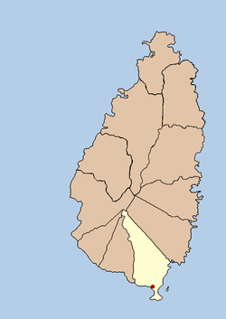
Vieux Fort is one of 10 districts of the Caribbean island country of Saint Lucia. Vieux Fort is also the name of the main town in the district. It is the home of the second-largest town in Saint Lucia and is the home of Saint Lucia's international airport, Hewanorra International Airport.

The island nation of Saint Lucia is divided into 10 districts. The name Quarters or Quartiers originally came from the French period in Saint Lucia. The 2001 and 2010 Census of Saint Lucia refers to the first level administrative divisions as districts. The FIPS and ISO standards regularly called these divisions quarters or quartiers in French. The former district of Dauphin Quarter was merged into Gros Islet District and the former district of Praslin Quarter was merged into Micoud District.

Marie-Galante is one of the dependencies of Guadeloupe, an overseas department of France. Marie-Galante has a land area of 158.1 km2. It had 11,528 inhabitants at the start of 2013, but by the start of 2018 the total was officially estimated to be 10,655, with a population density of 62.5/km2 (162/sq mi).

Castries District is one of 10 districts of the Caribbean island nation of Saint Lucia. According to the 2012 census, the population of the district was 80,573, having shown a slow but steady increase over the past ten years. The capital of Saint Lucia, the city of Castries, is located in this district. During the Saint Lucia Jazz Festival, the city of Castries plays host to several stages.
The Vieux Fort River is a river in Saint Lucia. It flows south-southeast, reaching the coast close to the country's southernmost point at the town of Vieux Fort. It is named after a fort that used to watch out towards Saint Vincent towards the south.

The George Odlum Stadium is a 9,000 capacity football stadium in Vieux Fort, Saint Lucia.

Saint Lucia, an island nation in the Caribbean islands, has a relatively large tourism industry. Due to the relatively small land area of the country, most of the governmental promotion is performed by the state-operated Saint Lucia Tourism Authority, led by Executive Chairperson Agnes.
Morne Fortune is a hill and residential area located south of Castries, Saint Lucia, in the West Indies.
La Tourney is a town in Vieux Fort District in the island country of Saint Lucia. La Tourney is in the La Tourney/Cedar Heights section of Vieux Fort District, which has a population of 706. La Tourney is located on the southern coast of Saint Lucia, close to Hewanorra International Airport. There is also a 127 m (417 ft) high Tourney Mountain nearby at 13°44′34″N60°57′55″W.
Beane Air Force Base was a United States Air Force base located near Vieux Fort, Saint Lucia, in the Caribbean Sea. It is now the site of Hewanorra International Airport.