
Andhra Pradesh is a state in the south-eastern coastal region of India. It is the seventh-largest state by area covering an area of 162,975 km2 (62,925 sq mi) and tenth-most populous state with 49,386,799 inhabitants, with the state capital being Amaravati. It is bordered by Telangana to the north-west, Chhattisgarh to the north, Odisha to the north-east, Tamil Nadu to the south, Karnataka to the west and the Bay of Bengal to the east. It has the second longest coastline in India after Gujarat, of about 974 km (605 mi). Andhra Pradesh is the first state to be formed on a linguistic basis in India on 1 October 1953. The state was once a major Buddhist pilgrimage site in the country and a Buddhist learning center which can be seen in many sites in the state in the form of ruins, chaityas and stupas It is also known as the land of the world-famous diamond Koh-i-Noor and many other globally known diamonds due to their source in its Kollur Mine. It is also known as the "rice bowl of India" for being a major producer of rice in India. Its official language is Telugu; one of the classical languages of India, the fourth most spoken language in India and the 11th-most spoken language in the world.

Visakhapatnam, formerly known as Vizagapatam is the largest and most populous city in the Indian state of Andhra Pradesh, and its proposed administrative capital. It is between the Eastern Ghats and the coast of the Bay of Bengal. It is the second-largest city on the east coast of India after Chennai, and the fourth-largest in South India. It is one of the four smart cities of Andhra Pradesh selected under the Smart Cities Mission and serves as the headquarters of Visakhapatnam district. With an estimated output of $43.5 billion, it is the ninth-largest contributor to India's gross domestic product as of 2016. In 2020, it was a finalist in the Living and Inclusion category of the World Smart City Awards.

Vizianagaram is a city and the headquarters of Vizianagaram district in the Indian state of Andhra Pradesh. It is central Eastern Ghats, about 24 km (15 mi) west of the Bay of Bengal and 40 km (25 mi) north-northeast of Visakhapatnam. The city has a population of 228,025 and was established as the capital of Vizianagaram estate by Raja Vijayaram Raj of Pusapati dynasty. The rulers had a notable role in the history of the region in 18th century and were patrons of education and arts.

Palakkad Gap or Palghat Gap is a low mountain pass in the Western Ghats between Coimbatore in Tamil Nadu and Palakkad in Kerala. It has an average elevation of 140 metres (460 ft) with a width of 24–30 kilometres (15–19 mi). The pass is located between the Nilgiri Hills to the north and Anaimalai Hills to the south.

Araku Valley is a hill station in Visakhapatnam district in the Indian state of Andhra Pradesh, lying 111 km west of Visakhapatnam city. This place is often referred to as Ooty of Andhra. It is a valley in the Eastern Ghats inhabited by different tribes, mainly Araku Tribes.

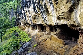
The Borra Caves, also called Borra Guhalu, are located on the East Coast of India, in the Ananthagiri hills of the Araku Valley of the Visakhapatnam district in Andhra Pradesh. The caves, one of the largest in the country, at an elevation of about 705 m (2,313 ft), distinctly exhibit a variety of speleothems ranging in size and irregularly shaped stalactites and stalagmites. The caves are basically karstic limestone structures extending to a depth of 80 m (260 ft), and are considered the deepest caves in India.

Anakapalle is a suburb of Visakhapatnam in the Indian state of Andhra Pradesh. The municipality was merged with Greater Visakhapatnam Municipal Corporation. It has the second largest jaggery market of the country.

Gunupur is a Municipality and one of the sub-divisional headquarters of Rayagada district in the Indian state of Odisha. It is the second biggest town in Rayagada district.

Kirandul is a town and a municipality in Dantewada district in the Indian state of Chhattisgarh. It is located roughly 400 km south of Raipur, capital of Chhattisgarh and 41 km southwest of Dantewada-the district headquarters. The way to travel is by road with frequent bus service from Raipur, Bhilai and Jagdalpur or by train from Jagdalpur and Visakhapatnam.

The Gosthani rises in the Ananthagiri Hills of the Eastern Ghats and flows through the Borra Caves which lie near its source. It is the largest river flowing through Visakhapatnam city. It flows for 120 km before joining the Bay of Bengal through an estuary near Bheemunipatnam. The river basin drains the two coastal districts of Vizianagaram and Visakhapatnam. The basin exhibits a subdendritic and dendritic pattern of drainage. The Gosthani's is a minor river basin with a total drainage area of less than 2000 km2. Much of the basin is covered by khondalite group of gneissic rocks. About 3% of the total area of the Visakhapatnam district is under the Gosthani basin. The river is rainfed, receiving an average rainfall of 110 cm most of which comes from the south-west monsoon. There are several red sand hills near Bheemunipatnam, where the Gosthani joins the Bay of Bengal, which are reminiscent of the Chambal ravines. These are thought to have been formed six millennia ago due to shifts in the river's course following tectonic activity. The river joins the Bay of Bengal at Bhimli where it forms an estuary.

Elamanchili is a town in Visakhapatnam district of the Indian state of Andhra Pradesh. It is a municipality and also the mandal headquarters of Elamanchili mandal. The town is spread over an area of 39 km2 (15 sq mi), which is under the jurisdiction of Visakhapatnam Metropolitan Region Development Authority. This town has historical importance dating back to 7th Century AD.

Andhra Pradesh is a state in India. Andhra Pradesh Tourism Development Corporation (APTDC) is a state government agency which promotes tourism in Andhra Pradesh, describing the state as the Koh-i-Noor of India. Andhra Pradesh has a variety of tourist attractions including beaches, hills, caves, wildlife, forests and temples.

Andhra Pradesh lies between 12°41' and 19.07°N latitude and 77° and 84°40'E longitude, and is bordered by Telangana to the north and west, Chhattisgarh to the north-west, Orissa to the north, the Bay of Bengal to the east, Tamil Nadu to the south and Karnataka to the southwest and west. Andhra Pradesh has a coastline of around 974 km, which gives it the second longest coastline in the nation. Two major rivers, the Godavari and the Krishna run across the state. A small enclave 12 sq mi (30 km²), the Yanam district of Puducherry, lies in the Godavari Delta in the north east of the state. The state includes the eastern part of Deccan plateau as well as a considerable part of the Eastern Ghats.

Kotturu Dhanadibbalu & Pandavula Guha is an ancient Buddhist site near Kotturu village of Rambilli mandal Visakhapatnam District of Andhra Pradesh. A post office is located at Kotturu Village with Pincode 531061
Thanale Caves or Nadsur Caves is a group of 23 Buddhist caves located 72 km (45 mi) to the southeast of Mumbai, in western Maharashtra, India, at Thanale Village, Taluka Sudhagad in Raigad, 18 km from Pali.

The Indian Institute of Management Visakhapatnam (IIMV) is a public business school and Institute of National Importance located in Visakhapatnam, Andhra Pradesh, India. It is one of the twenty Indian Institutes of Management. The institution started the first batch of its Post Graduate Program (PGP) in Management from August 2015. Visakhapatnam is the largest city in Indian state of Andhra Pradesh. The city is the administrative headquarters of Visakhapatnam district and the Eastern Naval Command of Indian Navy. Its geographical location is amidst Eastern Ghats mountain range and the coast of Bay of Bengal.

Bailadila Range, is a mountain range rising in the Deccan Plateau about 200 km west of the Eastern Ghats. It has been named 'Bailadila' because it resembles the hump of an ox. It is located near Kirandul town in the Dantewada district of southern Chhattisgarh, India.

Arma Konda or Sitamma Konda, is a mountain peak in the northern part of the Eastern Ghats and located in Godavari River basin. It is located in the Madugula Konda sub-range north of Paderu village in Andhra Pradesh, India.

The Simhachala Hill Range, with the anglicised name Simhachalam Hills, are a towering mountain range near the city of Visakhapatnam, in Andhra Pradesh state, southern India. It is one of the hill ranges in Andhra Pradesh and in the Eastern Ghats.

Visakhapatnam is located in Andhra Pradesh state in southeastern India. The city's area is 682 km2. It is located at 17°42′15″N83°17′52″E. The average elevation is 45 metres. Visakhpatnam is situated in Coastal Andhra Region.


