Viking-Bergen Banks

Last updated
North Sea map-en.png
175-free-google-maps-pointer.svg
Viking Bank

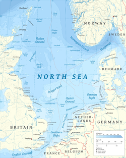
The Viking-Bergen Banks are underwater hills in the North Sea, east of Shetland and west of Norway. When sea levels were lower during the Last Glacial Period, the hills formed an island that may have been occupied by humans.

A map showing Viking-Bergen island to the north of Doggerland 10,000 BCE Doggerland.svg
A map showing Viking-Bergen island to the north of Doggerland 10,000 BCE

From approximately 15,500 to 13,600 years before present (BP), sea levels in the region were lower by 100 to 110 metres (330 to 360 ft), and possibly more than 140 metres (460 ft). [1] At this time, Viking-Bergen would have been an island surrounded by a shallow sea. [1] [2] If sea levels reached the lowest projected level, the formation may have existed for some time as hills at the northernmost extent of Doggerland; these hills would have been east of the Shetland hills, now the Shetland islands. [3] [4] Viking-Bergen may have been occupied during the Bølling–Allerød warming [5] based on a hypothetical piece of worked flint found near the banks. [2] [4] [6] The island was inundated by the North Sea by about 12,000 years BP [5] although it's possible that Viking-Bergen remained an island into the early Holocene. [2] [6]

Related Research Articles

The Holocene is the current geological epoch, beginning approximately 11,700 years ago. It follows the Last Glacial Period, which concluded with the Holocene glacial retreat. The Holocene and the preceding Pleistocene together form the Quaternary period. The Holocene is an interglacial period within the ongoing glacial cycles of the Quaternary, and is equivalent to Marine Isotope Stage 1.

<span class="mw-page-title-main">Lerwick</span> Human settlement in Scotland

Lerwick is the main town and port of the Shetland archipelago, Scotland. Shetland's only burgh, Lerwick had a population of about 7,000 residents in 2010.

<span class="mw-page-title-main">Prehistoric Britain</span> Prehistoric human occupation of Britain

Several species of humans have intermittently occupied Great Britain for almost a million years. The earliest evidence of human occupation around 900,000 years ago is at Happisburgh on the Norfolk coast, with stone tools and footprints probably made by Homo antecessor. The oldest human fossils, around 500,000 years old, are of Homo heidelbergensis at Boxgrove in Sussex. Until this time Britain had been permanently connected to the Continent by a chalk ridge between South East England and northern France called the Weald-Artois Anticline, but during the Anglian Glaciation around 425,000 years ago a megaflood broke through the ridge, and Britain became an island when sea levels rose during the following Hoxnian interglacial.

<span class="mw-page-title-main">Jarlshof</span> Archeological site in Shetland, Scotland

Jarlshof is the best-known prehistoric archaeological site in Shetland, Scotland. It lies in Sumburgh, Mainland, Shetland and has been described as "one of the most remarkable archaeological sites ever excavated in the British Isles". It contains remains dating from 2500 BC up to the 17th century AD.

<span class="mw-page-title-main">Upper Paleolithic</span> Subdivision of the Paleolithic or Old Stone Age

The Upper Paleolithic is the third and last subdivision of the Paleolithic or Old Stone Age. Very broadly, it dates to between 50,000 and 12,000 years ago, according to some theories coinciding with the appearance of behavioral modernity in early modern humans, until the advent of the Neolithic Revolution and agriculture.

<span class="mw-page-title-main">Storegga Slide</span> Prehistoric landslide off Norway

The three Storegga Slides are amongst the largest known submarine landslides. They occurred at the edge of Norway's continental shelf in the Norwegian Sea, approximately 6225–6170 BCE. The collapse involved an estimated 290 km (180 mi) length of coastal shelf, with a total volume of 3,500 km3 (840 cu mi) of debris, which caused a paleotsunami in the North Atlantic Ocean.

Sir Harry Godwin, FRS was a prominent English botanist and ecologist of the 20th century. He is considered to be an influential peatland scientist, who coined the phrase "peat archives" in 1981. He had a long association with Clare College, Cambridge.

Apalachee Bay is a bay in the northeastern Gulf of Mexico occupying an indentation of the Florida coast to the west of where the Florida peninsula joins the United States mainland. It is bordered by Taylor, Jefferson, Wakulla, and Franklin counties.

<span class="mw-page-title-main">Doggerland</span> Landmass currently beneath the North Sea that connected the British Isles to mainland Europe

Doggerland was an area of land in Northern Europe, now submerged beneath the North Sea, that connected Britain to continental Europe. It was repeatedly exposed at various times during the Pleistocene epoch due to the lowering of sea levels during glacial periods. It was last flooded by rising sea levels around 6500–6200 BCE. The flooded land is known as the Dogger Littoral. Geological surveys have suggested that it stretched from what is now the east coast of Great Britain to what is now the Netherlands, the western coast of Germany and the Danish peninsula of Jutland. It was probably a rich habitat with human habitation in the Mesolithic period, although rising sea levels gradually reduced it to low-lying islands before its final submergence, possibly following a tsunami caused by the Storegga Slide. Doggerland was named after the Dogger Bank, which in turn was named after 17th-century Dutch fishing boats called doggers.

Events from the prehistory of Britain.

The geography of the North Sea studies coastal and submarine features as well as the people who live on its coasts. It is bounded by the east coasts of England and Scotland to the west and the northern and central European mainland to the east and south, including Norway, Denmark, Germany, the Netherlands, Belgium, and France. In the south-west, beyond the Straits of Dover, the North Sea becomes the English Channel. In the east, it connects to the Baltic Sea via the Skagerrak and Kattegat, narrow straits that separate Denmark from Norway and Sweden respectively. In the north, it opens in a widening funnel shape to the Norwegian Sea, which lies in the very north-eastern part of the Atlantic.

The year 2009 in archaeology

<span class="mw-page-title-main">Outer Silver Pit</span>

The Outer Silver Pit is a west-to-east valley in the bed of the North Sea. Its widest part is 125 to 175 km east of Flamborough Head in England. It is between the Dogger Bank and the ridge dividing the northern from the southern North Sea basins, which runs between Norfolk and Friesland.

The History of Shetland concerns the subarctic archipelago of Shetland in Scotland. The early history of the islands is dominated by the influence of the Vikings. From the 14th century, it was incorporated into the Kingdom of Scotland, and later into the United Kingdom.

<span class="mw-page-title-main">Shippea Hill SSSI</span>

Shippea Hill SSSI is a 27.6-hectare (68-acre) geological Site of Special Scientific Interest east of Ely in Cambridgeshire, England. It is a Geological Conservation Review site.

Bryony Jean Coles, is a prehistoric archaeologist and academic. She is best known for her work studying Doggerland, an area of land now submerged beneath the North Sea.

<span class="mw-page-title-main">Vincent Gaffney</span> British archaeologist

Vincent Gaffney is a British archaeologist and the Anniversary Chair in Landscape Archaeology at the University of Bradford.

Olwyn Owen, FSA Scot, is a British archaeologist and academic specialising in Scandianvian Scotland.

The Northern European Enclosure Dam (NEED) is a proposed solution to the problem of rising ocean levels in Northern Europe. It would be a megaproject, involving the construction of two massive dams in the English Channel and the North Sea; the former between France and England, and the latter between Scotland and Norway. The concept was conceived by the oceanographers Sjoerd Groeskamp and Joakim Kjellsson.

References

  1. 1 2 Peacock, J. D. (1995-01-01). "Late Devensian to early holocene palaeoenvironmental changes in the Viking Bank area, northern North Sea". Quaternary Science Reviews. 14 (10): 1029–1042. Bibcode:1995QSRv...14.1029P. doi:10.1016/0277-3791(95)00041-0 . Retrieved 2023-07-03.
  2. 1 2 3 Coles, Bryony; Coles, John M.; Jørgensen, Mogens Schou (1999). Bog Bodies, Sacred Sites and Wetland Archaeology: Proceedings of a Conference Held by WARP and the National Museum of Denmark, in Conjunction with Silkeborg Museum, Jutland, September 1996. Wetland Archaeology Research Project. ISBN   9780951911754 . Retrieved 2023-07-03.
  3. Morris, Ian (2022-06-07). Geography Is Destiny: Britain and the World: A 10,000-Year History. Farrar, Straus and Giroux. ISBN   9780374717032 . Retrieved 2023-07-03.
  4. 1 2 Gaffney, Vincent; Thomson, Kenneth; Fitch, Simon (2007-12-12). Mapping Doggerland: The Mesolithic Landscapes of the Southern North Sea. Archaeopress Publishing Ltd. ISBN   9781784913250 . Retrieved 2023-07-03.
  5. 1 2 "Proceedings of the Prehistoric Society". University Museum of Archaeology and Ethnology. 1998. Retrieved 2023-07-03.
  6. 1 2 Gaffney, Vincent L.; Fitch, Simon; Smith, David N. (2009). Europe's Lost World: The Rediscovery of Doggerland. Council for British Archeology. ISBN   9781902771779 . Retrieved 2023-07-03.