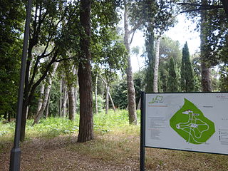
Villa Glori is a 25-hectare city park in Rome (Italy), within the Municipio II and the quarterParioli. It is also called Parco della Rimembranza (Italian for Park of Remembrance).
The park occupies a roughly quadrangular cliff – which is in fact the north-west end of the Monti Parioli – looking steeply towards the Tiber in the area of Acqua Acetosa and overhanging the Olympic Village and the Parco della Musica. It can be accessed from Piazzale del Parco della Rimembranza and Via Maresciallo Pilsudski.
History
The fortified casale.
Unlike the historic villas of Rome, Villa Glori was not born as a suburban villa, but as a rustic space intended for vineyards and hunting, so much so that the oldest building is a simple fortified farmhouse (casale), repeatedly remodeled and not even among the most beautiful of those scattered in the Roman Campagna
A first idea of the park was born at the beginning of the 19th century, when a never realized Napoleonic project included it in a Passeggiata Flaminia – the prolongation along Via Flaminia of the urban space that Giuseppe Valadier had gloriously concluded in piazza del Popolo – on the model of those that were being created in the rest of Europe.[1]
In the context of the campaign for the liberation of Rome of 1867, the area was the scene of the battle of Villa Glori, where the patriot Enrico Cairoli, among others, met his death. Cesare Pascarella immortalized the episode with a collection of 25 Sonnets entitled Villa Gloria, published in 1886, which is one of the very few examples of civil poetry in Romanesco dialect.
Soon after the capture of Rome, the 1883 master plan already included the idea of a vast green space between the Parioli and Ponte Milvio and for this purpose the expropriations were started. At the time the hill had passed from the Boncompagni to the engineer Vincenzo Glori, to whom Pius IX had entrusted the construction of the new Ponte Mammolo; the villa was then named after the latter owner.
An hippodrome for trotting races was built in 1908 in the plain under the cliff, in a location still very close to the historic center. The facility was operational until the end of 1950s, when it was replaced by the much larger Hippodrome of Tor di Valle, while on the site of the former hippodrome of Villa Glori the Olympic Village was built.[2]
In 1923 the villa, formerly owned by Glori, was turned into a public park to commemorate the fallen of the Great War and was called (as in many other Italian cities) Parco della Rimembranza,[3] though it also maintained the original name of Villa Glori. The design of the new park was entrusted to the architect Raffaele De Vico and consisted mainly in the realization of the central square and of a network of avenues, as well as the planting of over 6,000 trees and shrubs. The inauguration took place in 1924.
In 1929 three pavilions dedicated to Ettore Marchiafava were built at the top of the hill, intended as a dispensary and summer colony for poor children at risk of tuberculosis. For the same purposes, a few years later a school was built next to it, alongside the old casale. In continuity with this sanitary tradition, since 1988 the former facilities, partially restored, have been entrusted to Roman Caritas, which has installed there a foster home housing AIDS patients.
In 1997, at the suggestion of the art critic Daniela Fonti, the Municipality of Rome established a permanent exhibition of contemporary sculpture called Varcare la Soglia ("Crossing the threshold"), aimed at integrating nature and art. In 2000 the exhibition acquired two new works: Gate of the Sun by Giuseppe Uncini and Grass-man by Paolo Canevari.
↑ The memory of the former horse riding activities is now preserved only by the presence – in a corner of the area of the former racecourse – of a private horse-riding center, managed by Polisportiva S.S. Lazio.
↑ Today the park is dedicated to the Roman fallen of all wars.
Alberta Campitelli, Villa Glori in Gli anni del Governatorato (1926–1944), pp.169–172, Series Quaderni dei monumenti, Rome, Edizioni Kappa, 1995. ISBN88-7890-181-4.
Daniela Fonti, Il parco di scultura di Villa Glori, Rome, De Luca Editori d'Arte, 2000
External links
"Villa Glori". Sovrintendenza Capitolina ai Beni Culturali. Retrieved 11 December 2019.
Trastevere is the 13th rione of Rome: it is identified by the initials R. XIII and it is located within Municipio I. Its name comes from Latin trans Tiberim, literally 'beyond the Tiber'.
Parioli is the 2nd quartiere of Rome, identified by the initials Q. II.
Lucos Cozza was a Roman archaeologist.
Piazza del Popolo is a large urban square in Rome. The name in modern Italian literally means "People's Square", but historically it derives from the poplars after which the church of Santa Maria del Popolo, in the northeast corner of the piazza, takes its name.
Labaro is the 57th zona of Rome, identified by the initials Z. LVII. It is located 11 kilometres north of the city center, along the Via Flaminia, just outside the Grande Raccordo Anulare.
Val Melaina is the 1st zona of Rome, identified by the initials Z. I, lying north of the city centre and covering an area of 6.2447 km ².
Municipio Roma III is the third administrative subdivision of Rome (Italy).
The following outline is provided as an overview of and topical guide to Rome:
Flaminio is the 1st quartiere of the Italian capital Rome. Identified by the initials Q. I, it belongs to the Municipio II and has 13,018 inhabitants and an area of 1.1877 km². The name is derived from the Via Flaminia.
Tor Cervara is the 7th zona of the Italian capital Rome, identified by the initials Z. VII. It belongs to the Municipio IV and has 13,975 inhabitants (2016). It is located in the east of the city, within the Grande Raccordo Anulare, and has an area of 5.9000 km².
Municipio Roma VII is the seventh administrative subdivision of the Municipality of Rome (Italy).
Pinciano is the 3rd quartiere of Rome (Italy), identified by the initials Q. III. The name derives from the Pincian Hill. It belongs to the Municipio II.
Castel Giubileo is the second Zone of Rome in the Ager Romanus, identified as Z. II.
The Laurentino-Acqua Acetosa nature reserve is a protected natural area located in the Province of Rome.
The Fontana dell'Acqua Acetosa is a fountain in Rome (Italy), located in the flat area with the same name, in the quarter Parioli; at this point the river Tiber forms a deep bend before heading north again. The fountain rises at a lower elevation than the street level, and is therefore accessed via a staircase. In 2003 the Fondo Ambiente Italiano, on the basis of a popular survey, identified it as the monument to which Italians are fondest of.
The Piazza Euclide railway station is a railway station in Rome (Italy), on the Rome–Civitacastellana–Viterbo railway, managed by ATAC. It is the only underground stop of the line, excluding the Flaminio terminus.
Ponte Flaminio is a bridge in Rome (Italy), crossed by Corso di Francia, in the Quartieri Parioli and Tor di Quinto and in the zone of Vigna Clara.
Corso di Francia, informally called Corso Francia, is a street in the northern area of Rome (Italy). It runs in a south–north direction between the Quarters Parioli and Tor di Quinto and, together with the nearby Via del Foro Italico and Viale Guglielmo Marconi, is the only urban road in the town to overpass the Tiber keeping the same name on both banks.
Armando Brasini was a prominent Italian architect and urban designer of the early twentieth century and exemplar of Fascist architecture. His work is notable for its eclectic and visionary style inspired by Ancient Roman architecture, Italian Baroque architecture and Giovanni Battista Piranesi.
This page is based on this Wikipedia article Text is available under the CC BY-SA 4.0 license; additional terms may apply. Images, videos and audio are available under their respective licenses.