Cabo San Lucas, or simply Cabo, is a resort city at the southern tip of the Baja California Peninsula, in the Mexican state of Baja California Sur. As of 2015, the population of the city was 81,111 inhabitants. Cabo San Lucas together with San José del Cabo is known as Los Cabos. Together they form a metropolitan area of 305,983 inhabitants.
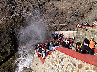
La Bufadora is a marine geyser or blowhole located on the Punta Banda Peninsula in Baja California, Mexico. The spout of sea water is the result of air, trapped in a sea cave, exploding upwards. Air is forced into the cave by wave action and is released when the water recedes. This interaction not only creates the spout, but a thunderous noise as well. The phenomena repeats every minute or so with its volume depending on the strength of the waves.

Mission Santo Domingo was founded among the Kiliwa Indians of Baja California, Mexico, by the Dominicans Miguel Hidalgo and Manuel García in 1775. It is located near Colonia Vicente Guerrero and northeast of San Quintín Bay.

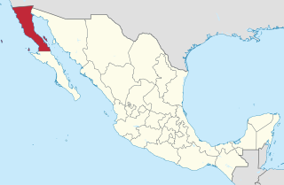
The municipality of Ensenada, with a land area of 52,482.40 km2 (20,263.57 sq mi), takes up the majority of the state of Baja California. It is the largest municipality in Mexico and in the Americas by area. It contains all of Baja California apart from a strip at the north and, at the northeast extremity of the state, the municipality of Mexicali. It is bordered by the Pacific Ocean on the west, the Gulf of California on the east, and by all of the other municipalities in Baja California on the North. Its municipal seat is Ensenada, which lies near the northwest corner of the municipality, although almost all of the municipality's territory lies far to its southeast. Its current municipal president is Enrique Pelayo Torres. A major port is planned to be built in Punta Colonet, a largely uninhabited area 80 km (50 mi) south of the city of Ensenada. Located offshore, Guadalupe Island is part of the municipality, making Ensenada the westernmost municipality of Latin America.

Federal Highway 1 is a free (libre) part of the federal highway corridors of Mexico, and the highway follows the length of the Baja California Peninsula from Tijuana, Baja California, in the north to Cabo San Lucas, Baja California Sur, in the south. The road connects with Via Rapida, which merges into the American Interstate 5 (I-5) at the international border south of San Ysidro, California.

Tijuana Municipality is a municipality in the Mexican state of Baja California. Its municipal seat is located in the city of Tijuana. According to the 2010 census, the municipality had a population of 1,559,683 inhabitants, of whom 1,300,983, or 83.4%, lived in the city of Tijuana. The municipality maintained its position as 3rd most populated nationally as of 2015 census, only behind Ecatepec de Morelos and Iztapalapa. Carlos Bustamante Anchondo of the PRI is the current municipal president. The municipality comprises the largest part of the Tijuana metropolitan area.
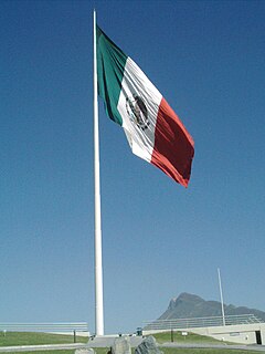
The banderas monumentales are a collection of tall flagpoles containing large flags of Mexico located throughout Mexico. They are part of a program started in 1999 under President Ernesto Zedillo that is currently administered by the Secretariat of National Defense. The main feature of these monuments is a giant Mexican flag flying off a 50-meter-high flagpole. The size of the flag was 14.3 by 25 meters and it was flown on a pole that measured 50 meters high. In the time after the decree was issued, many more banderas monumentales have been installed throughout the country in various sizes. Many of the locations were chosen due to significant events in Mexican history that occurred there.

The Spanish missions in Baja California were a large number of religious outposts established by Catholic religious orders, the Jesuits, the Franciscans and the Dominicans, between 1683 and 1834 to spread the Christian doctrine among the Native Americans or Indians living on the Baja California peninsula. The missions gave Spain a valuable toehold in the frontier land, and introduced European livestock, fruits, vegetables, and industry into the region. The Indians were severely impacted by the introduction of European diseases such as smallpox and measles and by 1800 their numbers were a fraction of what they had been before the arrival of the Spanish.
Maxcanú is a large town in the western part of the Mexican state of Yucatán; it also functions as the seat for the Maxcanú Municipality. It is located on Federal Highway 180, approximately 62 km (38.5 mi) south of Mérida.
Cárdenas is the second-largest city in the state of Tabasco, in southeastern Mexico. It lies in the northwestern part of the state, on the Gulf of Mexico coast, east of the city of Coatzacoalcos, Veracruz. The city is the municipal seat of Cárdenas Municipality. At the census of 2005 the city had a population of 79,875 inhabitants, while the municipality had 219,563 inhabitants. There are numerous smaller communities in the municipality, but the largest are Sánchez Magallanes and Campo Magallanes. The area of the municipality is 2,112 km².
Villa Hidalgo Municipality is a municipality, in the north-east of the Mexican state of Sonora.
Villa Hidalgo Yalalag is a village in Oaxaca, Mexico. It is located near Villa Alta District in the center of the Sierra Norte Region.
The following radio stations broadcast on AM frequency 1470 kHz: 1470 AM is a Regional broadcast frequency.
Ahsahka is a small Unincorporated community located in Clearwater County, Idaho, United States, and is close to the Dworshak Dam. Ahsahka is located at 46°30′08″N116°19′27″W.

Baja California Territory was a Mexican territory from 1824 to 1931, that encompassed the Baja California Peninsula of present-day northwestern Mexico. It replaced the Baja California Province (1773–1824) of the Spanish colonial Viceroyalty of New Spain, after Mexican independence. Along with Alta California, the two territories were split from the Spanish The Californias region.

The Islas Marías are an archipelago of four islands that belong to Mexico. They are located in the Pacific Ocean, some 100 km (62 mi) off the coast of the state of Nayarit and about 370 km (230 mi) southeast of the tip of Baja California. They are part of the municipality (municipio) of San Blas, Nayarit. As of 2011, the islands were used as a penal colony until February 18th of 2019 when Andres Manuel Lopez Obrador ordered the closure of its operation as Islas Marías Federal Prison.
Villa del Prado is a city in Baja California in Tijuana Municipality. The city had a population of 12,303 as of 2010.
Villa del Campo – Town of the Country – is a city in Baja California in Tijuana Municipality. The city had a population of 13,906 as of 2010.