Villa Hidalgo (Villaflores), Chiapas

Last updated
Villa Hidalgo
Mexico States blank map.svg
Red pog.svg
Villa Hidalgo
Location in Mexico
Coordinates: 16°18′N93°09′W / 16.300°N 93.150°W / 16.300; -93.150
CountryFlag of Mexico.svg  Mexico
State Chiapas
Population
(2010)
  Total2,502

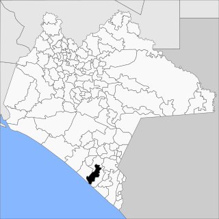
Villa Hidalgo is located within the municipality of Villaflores, in northern Chiapas, Mexico. As of 2010, it had a population of 2,502. [1]

Villaflores, Chiapas Municipality in Chiapas, Mexico

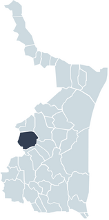
Villaflores Municipality is a municipio (municipality) in the state of Chiapas, southern Mexico, and the name of its largest settlement and seat of the municipal government. Situated in the Sierra Madre de Chiapas range, the municipality has an area of approximately 1232 km2 at an average elevation of 540m above mean sea level.

Chiapas State of Mexico

Chiapas, officially the Free and Sovereign State of Chiapas, is one of the 31 states that along with the federal district of Mexico City make up the 32 federal entities of Mexico. It is divided into 124 municipalities as of September 2017 and its capital city is Tuxtla Gutiérrez. Other important population centers in Chiapas include Ocosingo, Tapachula, San Cristóbal de las Casas, Comitán and Arriaga. It is the southernmost state in Mexico. It is located in Southeastern Mexico, and it borders the states of Oaxaca to the west, Veracruz to the northwest and Tabasco to the north, and by the Petén, Quiché, Huehuetenango and San Marcos departments of Guatemala to the east and southeast. Chiapas has a coastline along the Pacific Ocean to the south.

Mexico country in the southern portion of North America

Mexico, officially the United Mexican States, is a country in the southern portion of North America. It is bordered to the north by the United States; to the south and west by the Pacific Ocean; to the southeast by Guatemala, Belize, and the Caribbean Sea; and to the east by the Gulf of Mexico. Covering almost 2,000,000 square kilometres (770,000 sq mi), the nation is the fifth largest country in the Americas by total area and the 13th largest independent state in the world. With an estimated population of over 120 million people, the country is the eleventh most populous state and the most populous Spanish-speaking state in the world, while being the second most populous nation in Latin America after Brazil. Mexico is a federation comprising 31 states and Mexico City, a special federal entity that is also the capital city and its most populous city. Other metropolises in the state include Guadalajara, Monterrey, Puebla, Toluca, Tijuana and León.

Coordinates: 16°18′N93°09′W / 16.300°N 93.150°W / 16.300; -93.150

Geographic coordinate system Coordinate system

A geographic coordinate system is a coordinate system that enables every location on Earth to be specified by a set of numbers, letters or symbols. The coordinates are often chosen such that one of the numbers represents a vertical position and two or three of the numbers represent a horizontal position; alternatively, a geographic position may be expressed in a combined three-dimensional Cartesian vector. A common choice of coordinates is latitude, longitude and elevation. To specify a location on a plane requires a map projection.

Related Research Articles

Hidalgo may refer to:

Colonia Villa de Guadalupe is a former separate town, now a neighborhood in northern Mexico City which in 1531 was the site of the apparition of Our Lady of Guadalupe, the most renowned Marian apparition in the Americas. She can be venerated in the Our Lady of Guadalupe Shrine, located in the villa (town).

Suchiate Municipality in Chiapas, Mexico

Suchiate is a municipality in the Mexican state of Chiapas, on the border with Guatemala. It is in the Soconusco region, and is the southernmost municipality both in Chiapas and in all of Mexico. On the eastern edge of the municipality, flowing from north to south, is the Río Suchiate, which forms the international border. Two communities within the municipality are border crossings with Guatemala, Ciudad Hidalgo and Talismán. Ciudad Hidalgo is the municipal seat and has a customs house at the border. Suchiate reported a 2010 census population of 35,056 persons. It has a land area of 606.1 km2 (234.0 sq mi).

Sierra Madre de Oaxaca

The Sierra Madre de Oaxaca is a mountain range in southern Mexico. It is primarily in the state of Oaxaca, and extends north into the states of Puebla and Veracruz.

Ayutla, San Marcos Place in San Marcos, Guatemala

Ayutla is a municipality in the San Marcos Department of Guatemala. It is situated along the Suchiate River natural border with Mexico in the southern part of the department. The municipality center is Ciudad Tecún Umán. There is a combined road and rail bridge known as Puente Rodolfo Robles linking Ayutla to Ciudad Hidalgo in Chiapas, Mexico.

Villa Hidalgo Municipality is a municipality, in the north-east of the Mexican state of Sonora.

Hidalgo, Tamaulipas Place in Tamaulipas, Mexico

Hidalgo Municipality is a municipality located in the Mexican state of Tamaulipas. El Chorrito is a centre of pilgrimage in the municipality.

Villa Hidalgo, Jalisco Municipality and Town in Jalisco, Mexico

Villa Hidalgo is a town and municipality in the state of Jalisco in Mexico.

Villa Hidalgo, Durango Municipal seat and city in Durango, Mexico

Villa Hidalgo is a town in the Mexican state of Durango. It serves as the head town of Hidalgo Municipality. As of 2010, the town had a population of 614.

Villa Hidalgo (Tuzantán), Chiapas Place in Chiapas, Mexico

Villa Hidalgo is a village in the municipality of Tuzantán, Chiapas, Mexico. As of 2010, the village had a population of 1,089.

Villa de Hidalgo, San Luis Potosí human settlement

Villa de Hidalgo is a village in San Luis Potosí, Mexico.

Villa Hidalgo, Chiapas may refer to:

Villa Corzo Municipality in Chiapas, Mexico

Villa Corzo is a city and one of the 119 municipalities of Chiapas, in southern Mexico. The city of Villa Corzo (the municipal seat is located at

Villa Comaltitlán Municipality in Chiapas, Mexico

Villa Comaltitlán is a town and one of the 119 Municipalities of Chiapas, in southern Mexico.

Tuzantán Municipality in Chiapas, Mexico

Tuzantán is a town and one of the 119 Municipalities of Chiapas, in southern Mexico.

Tenth Federal Electoral District of Chiapas federal electoral district of Mexico

The Tenth Federal Electoral District of Chiapas(X Distrito Electoral Federal de Chiapas) is one of the 300 Electoral Districts into which Mexico is divided for the purpose of elections to the federal Chamber of Deputies and one of 12 such districts in the state of Chiapas.

Regional Museum of Anthropology and History of Chiapas

The Regional Museum of Anthropology and History of Chiapas is the largest museum in Tuxtla Gutiérrez in Chiapas and one of the most important of its kind in Mexico. It primarily consists of two main halls with one dedicated to the state’s Mesoamerican archeology and the other to the history of the state starting from the Spanish conquest. The archeological display focus on the native Zoque and Mayan cities, and the historical displays extend in time until the early 20th century. In addition to its permanent collection, it also has a temporary exhibit hall and auditorium to host events such as book signings, summer classes, conferences and more.

Museo de la Laca and the Santo Domingo monastery

The former monastery of Santo Domingo/Museo de la Laca is located in the city of Chiapa de Corzo, Chiapas, Mexico. The monastery with its church was built in the 16th century, with the monastery secularized later. The church retains its original function. The building with two courtyards was restored between 1999 and 2002 to become a community and cultural center, with the Museo de la Laca, founded in 1952, moved inside to take up much of the upper floor. This museum contains about 450 pieces from various parts of Mexico and Asia, mostly made in the 20th century. The complex also contains halls with permanent and temporary exhibits along with an auditorium and various types of workshops.

The following television stations broadcast on digital channel 26 in Mexico:

References

  1. "Villaflores". Catálogo de Localidades. Secretaría de Desarrollo Social (SEDESOL). Retrieved 23 April 2014.

The GEOnet Names Server (GNS) provides access to the National Geospatial-Intelligence Agency's (NGA) and the U.S. Board on Geographic Names's (BGN) database of geographic feature names and locations for locations outside the United States. The database is the official repository of foreign place-name decisions approved by the US BGN. Approximately 20,000 of the database's features are updated monthly. The database never removes an entry, "except in cases of obvious duplication".