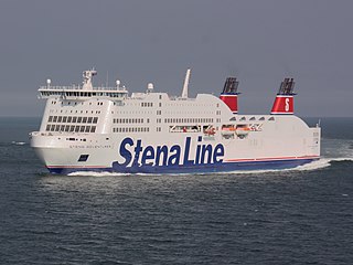
A ferry is a merchant vessel used to carry passengers, and sometimes vehicles and cargo, across a body of water. A passenger ferry with many stops, such as in Venice, Italy, is sometimes called a water bus or water taxi.

Transport in Norway is highly influenced by Norway's low population density, narrow shape and long coastline. Norway has old water transport traditions, but road, rail and air transport have increased in importance during the 20th century. Due to the low population density, public transport is somewhat less built out in rural areas of Norway, however public transport in, and around cities is well developed.

The Oslo Metro is the rapid transit system of Oslo, Norway, operated by Sporveien T-banen on contract from the transit authority Ruter. The network consists of five lines that all run through the city centre, with a total length of 85 kilometres (53 mi), serving 101 stations of which 17 are underground or indoors. In addition to serving 14 out of the 15 boroughs of Oslo, two lines run to Kolsås and Østerås, in the neighboring municipality of Bærum. In 2016, the system had an annual ridership of 118 million.

Sporveien Oslo AS is a municipally owned public transport operator in Oslo, Norway. It operates the trackage and maintains the stock of the Oslo Metro and Oslo Tramway, as well as owning eight operating subsidiaries. In 2005, its 2,365 employees transported 160 million passengers 710 million kilometers, and since 2008 it has operated on contract with the public transport authority Ruter.
The Oslo tram network is the tram system in Oslo, Norway. It consists of six lines with 99 stops and has a daily ridership of 132,000. It is operated by Sporveien Trikken AS, a subsidiary of the municipally-owned Sporveien who maintain the track and 72 tram vehicles on contracts with the public transport authority Ruter. The system operates on standard gauge and uses 750 V DC overhead. Depot, workshops and headquarters are at Grefsen. There is also a depot at Holtet that is home to the technical company InfraPartner, which maintains the track for the tram and metro systems in Oslo, and a small office building for Oslo Sporveier.

Bjørvika is a neighborhood in the Sentrum borough of Oslo, Norway. The area is an inlet in the inner Oslofjord, situated between Gamlebyen and Akershus Fortress. It serves as an outlet for the river Akerselva. Since the 2000s, it has been undergoing urban redevelopment, being transformed from a container port. When completed, the Bjørvika neighborhood will be a new cultural and urban center in Oslo. The multi-purpose medium-rises of the Barcode Project dominates the skyline to the north; to the east the residential area of Sørenga is under construction. The National Opera is located at Bjørvika, and both the Oslo Public Library and the Munch/Stenersen museum is currently under construction here, the latter replacing the existing Munch Museum in 2020.

AS Oslo Sporveier is a defunct municipal owned company responsible for public transport in Oslo, Norway. It was created in 1924 to take over the city's two private tram companies. In 1927 its started with bus transport, including from 1940 to 1968 trolleybuses. Since 1966 rapid transit and from 1985 water buses have also been operated by the company. It was split into two separate companies in 2006; Kollektivtransportproduksjon took over the operation while Oslo Public Transport Administration was responsible for buying the services, fare regulation and marketing. The latter merged into Ruter in 2008, when the Oslo Sporveier brand was discontinued.
AS Sporveisbussene is a bus company that operates about 75% of the routes in Oslo, Norway. The company was created in 1997 when the then Oslo Sporveier was reorganised. It is now a subsidiary of Kollektivtransportproduksjon, a municipal company responsible for operating public transport in Oslo. In 2003 the Oslo City Council decided that bus transport in Oslo was to be based on public service obligation contracts, and Sporveisbussene has steadily lost its routes to these contracts. Instead, Sporveisbussene has established a subsidiary, Nexus Trafikk, that can compete in the competitions, and has won many of them. The company also operates the express coaches branded Lavprisekspressen.

The Sagene Line is an abandoned line of the Oslo Tramway in Norway. It ran from Stortorvet in the city center along Akersgata and Ullevålsveien through the neighborhood of St. Hanshaugen. It then continued along Colletts gate, Geitmyrsveien and Kierschouws gate to Sagene. At Sagene Church it had a regulation stop and access to Sagene Depot. The line continued along Bentsebrugata to Torshov, where it intersected with the Grünerløkka–Torshov Line.
Ruter AS is the public transport authority for Oslo and Akershus counties in Norway. Formally a limited company – 60% of its shares are owned by the Oslo county municipality and 40% by that of Akershus – it is responsible for the administration, funding, and marketing of public transport in the two counties, including buses, the Oslo Metro, Oslo Trams, and ferry services. Ruter also holds agreements with Norwegian State Railways concerning the regulation of fares on local and regional train services operated within the two counties.

The Moss–Horten Ferry is an automobile ferry on Norwegian National Highway 19 that connects the counties of Østfold and Vestfold at the quays of Moss and Horten. The 10.5 kilometres (6.5 mi) crossing of Oslofjord is performed with three double-ended ferries operated by Bastø Fosen, making the crossing in 30 minutes, with departures twice an hour. In 2008 the line had a daily ridership of 3720 people and 4086 vehicles. It is the most trafficked car ferry line in Norway.

Kristiania Kommunale Sporveie or KKS, colloquially known as the Red Tramway was a municipal owned company that operated parts of the Oslo Tramway from 1899 to 1905. KKS built and operated three lines, Sagene Ring, the Rodeløkka Line and the Vippetangen Line. The three were connected by means of lines of Kristiania Sporveisselskab (KSS) and Kristiania Elektriske Sporvei (KES). KKS bought twenty motorized trams from Schuckert & Co. and twelve trailers, designated as Class S. It built two depots, Sagene and Rodeløkka.
The Vippetangen Line or the Grain Tram is an abandoned line of the Oslo Tramway, Norway, that ran from Tollbugata in the city center to Vippetangen between 1900 and 1967. It was built by Kristiania Kommunale Sporveie (KKS).

The Ullevål Hageby Line is a light rail section of the Oslo Tramway. It runs from Stortorvet in the city center of Oslo, Norway to Rikshospitalet. It passes through the areas of St. Hanshaugen, Ullevål Hageby and Blindern before reaching Gaustad. It serves major institutions such as Oslo University College, Bislett Stadion, Ullevål University Hospital, the University of Oslo and Rikshospitalet. The line is served by route 17 and 18 by Oslo Sporvognsdrift using SL95 trams, while the tracks are owned by Kollektivtransportproduksjon.

The Vika Line is a light rail section of the Oslo Tramway in Oslo, Norway. It runs between Wessels plass, through the neighborhood of Vika and Aker Brygge, before arriving at Solli. The section is served by SL79 trams on line 12. The line is owned by the municipal company Kollektivtransportproduksjon, and operated by its subsidiary Oslo Sporvognsdrift.

The history of the Oslo Tramway and Oslo Metro in Oslo, Norway, starts in 1875, when Kristiania Sporveisselskab (KSS) opened two horsecar lines through the city centre. In 1894, Kristiania Elektriske Sporvei (KES) built the first electric street tramways, which ran west from the city centre. Within six years, all tramways were electric. The city council established Kristiania Kommunale Sporveie (KKS) in 1899, which built three lines before it was sold to KSS six years later. Both KSS and KES were taken over by the municipality in 1924, becoming Oslo Sporveier. The company gradually expanded the city tram network, which reached its peak length in 1939.

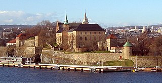
Rådhusplassen is a square located between Oslo City Hall and the Oslofjord in Vika, Oslo, Norway. Previously used as a road and part of European route E18, it has since 1994 served as a recreational area. North of the square stands the city hall, to the south the fjord, to the east Akershus Fortress and to the east the former Western Railway Station.

Filipstad is a neighborhood in the Frogner borough in Oslo, Norway. It serves both as a major container port and ferry terminal for the city. The Oslo-Kiel ferry docks by the Hjortneskaia at Filipstad.

The Fjord City is an urban renewal project for the waterfront part of the center of Oslo, Norway. The first redevelopment was at Aker Brygge during the 1980s. Bjørvika and Tjuvholmen followed up during the 2000s, while the remaining parts of the Port of Oslo will be developed in the 2010s. The port will be relocated to Sørhavna. The planning is performed by the Oslo Waterfront Planning Office. Major investments in the area include a new Central Railway Station, an already completed Oslo Opera House, and the commercial buildings in the Barcode Project. Several large cultural institutions will be moved to Bjørvika, including moving the Oseberg Ship, Oslo Public Library, and the Munch Museum. The main barrier between the city and the fjord will disappear when European Route E18 is relocated to the Bjørvika Tunnel.
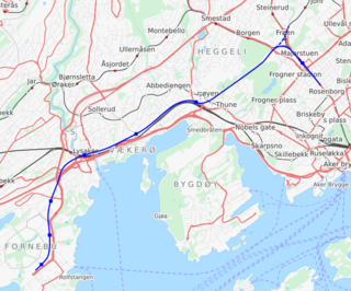
The Fornebu Line is a proposed rail line which would serve the peninsula of Fornebu in Bærum, Norway. The line is in the planning stages and the transit agency Ruter is working towards connecting it to the Oslo Metro. The line has at various stages been proposed as a automated people mover, tram-train, tramway, light rail, stadtbahn, rapid transit, bus rapid transit and commuter rail. The current proposal consists of a metro line starting at Majorstuen Station and running entirely in a tunnel for 8,150 meters (26,740 ft). It would possible have a station at Madserud, and then stations at Skøyen, Vækerø, Lysaker, Telenor Arena, Flytårnet and Fornebu Senter. A depot would be built at Fornebu and the line would connect to the metro's Common Tunnel at Majorstuen.