Related Research Articles
The Cook Mountains is a group of mountains bounded by the Mulock and Darwin glaciers in Antarctica. They are south of the Worcester Range and north of the Darwin Mountains and the Britannia Range.

The Darwin Glacier is a large glacier in Antarctica. It flows from the polar plateau eastward between the Darwin Mountains and the Cook Mountains to the Ross Ice Shelf. The Darwin and its major tributary the Hatherton are often treated as one system, the Darwin–Hatherton.
The Deep Freeze Range is a rugged mountain range, over 80 nautical miles long and about 10 nautical miles wide, rising between Priestley and Campbell Glaciers in Victoria Land, Antarctica, and extending from the edge of the polar plateau to Terra Nova Bay. It is southwest of the Southern Cross Mountains, south of the Mesa Range and northeast of the Eisenhower Range of the Prince Albert Mountains.

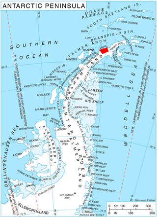
James Ross Island is a large island off the southeast side and near the northeastern extremity of the Antarctic Peninsula, from which it is separated by Prince Gustav Channel. Rising to 1,630 metres (5,350 ft), it is irregularly shaped and extends 64 km in a north–south direction. It was charted in October 1903 by the Swedish Antarctic Expedition under Otto Nordenskiöld, who named it for Sir James Clark Ross, the leader of a British expedition to this area in 1842 that discovered and roughly charted a number of points along the eastern side of the island. The style, "James" Ross Island is used to avoid confusion with the more widely known Ross Island in McMurdo Sound.
The Possession Islands are a group of small islands and rocks extending over an area of about 7 nautical miles, lying in the western part of the Ross Sea, lying 5 nautical miles south-east of Cape McCormick, in Victoria Land, Antarctica. The Possession Islands were named by Captain James Clark Ross, Royal Navy, in commemoration of the planting of the British flag here on January 12, 1841.

Northeast Glacier is a steep, heavily crevassed glacier on the west side of Hemimont Plateau, 21 km (13 mi) long and 8 km (5 mi) wide at its mouth, which flows from McLeod Hill westward and then south-westwards into Marguerite Bay between the Debenham Islands and Roman Four Promontory, on the west coast of Graham Land, Antarctica. Northeast Glacier was first surveyed in 1936 by the British Graham Land Expedition (BGLE) under John Riddoch Rymill. It was resurveyed in 1940 by members of the United States Antarctic Service (USAS), who first used the glacier as a sledging route, and so named by them because it lay on the north-eastern side of their base at Stonington Island.
Foundation Ice Stream is a major ice stream in the Pensacola Mountains of Antarctica. The ice stream drains northward for 150 nautical miles along the west side of the Patuxent Range and the Neptune Range to enter the Ronne Ice Shelf westward of Dufek Massif.
The Quartz Hills is an arcuate cluster of largely ice-free hills and peaks found immediately south of Colorado Glacier along the west side of Reedy Glacier. They are part of the Transantarctic Mountains of Antarctica.
Wilson Hills is a group of scattered hills, nunataks and ridges that extend northwest–southeast about 70 nautical miles between Matusevich Glacier and Pryor Glacier in Antarctica.
Orphir is a parish and settlement on Mainland, Orkney, Scotland.
Ulu Peninsula is that portion of James Ross Island northwest of the narrow neck of land between Rohss Bay and Croft Bay, extending from Cape Obelisk to Cape Lachman. Named descriptively by the United Kingdom Antarctic Place-Names Committee (UK-APC) in 1987. In plan view the cove is shaped like an ulu, a type of knife traditionally used by Inuit women.
The Gothic Mountains is a group of mountains, 20 nautical miles long, in the Queen Maud Mountains of Antarctica, located west of Watson Escarpment and bounded by Scott Glacier, Albanus Glacier, and Griffith Glacier.
Chanute Peak is a peak in Korten Ridge on the east side of Lanchester Bay, 4 nautical miles (7 km) south of Wennersgaard Point, Davis Coast in Graham Land. It was named by the UK Antarctic Place-Names Committee for Octave Chanute, an American designer of gliders who first introduced moveable planes for the purpose of control and stability in 1896–97.
Suvorov Glacier is a glacier, 5 nautical miles wide, flowing east from the Wilson Hills and discharging into the sea south of Northrup Head and Belousov Point. The glacier was mapped by the Soviet Antarctic Expedition, 1958, and named after V.S. Suvorov, Soviet mechanic who perished in the Arctic.
Moubray Bay is a bay in the western Ross Sea, indenting the coast of Victoria Land, Antarctica, between Cape Roget and Cape Hallett. It was discovered in 1841 by Sir James Clark Ross and named by him for George H. Moubray, clerk in charge of the expedition ship Terror.
Miethe Glacier is a glacier 3 nautical miles (6 km) long, flowing northwest into Gerlache Strait to the south of Mount Banck, on the west coast of Graham Land, Antarctica. The glacier appears on an Argentine government chart of 1952. It was named by the UK Antarctic Place-Names Committee in 1960 for Adolf Miethe, a German chemist who introduced the first panchromatic emulsion for photographic plates in 1903.
Hobbs Ridge is a prominent arc-shaped ridge which circumscribes Hobbs Glacier to the north and northwest and forms the divide with the lower part of Blue Glacier, on the Scott Coast of Victoria Land, Antarctica. It was named in association with Hobbs Glacier. It forms the northernmost part of the Denton Hills.

La Grange Nunataks is a scattered group of nunataks extending west for 22 nautical miles (41 km) from the mouth of Gordon Glacier, on the north side of the Shackleton Range, Antarctica. They were first mapped in 1957 by the Commonwealth Trans-Antarctic Expedition (CTAE), and were photographed in 1967 by U.S. Navy aircraft. They were named by the UK Antarctic Place-Names Committee for Johannes J. La Grange, a South African meteorologist with the CTAE. Not: Beney Nunataks.
Cape Roquemaurel is a prominent rocky Antarctic headland at the east side of the entrance to Bone Bay, on the north side of Trinity Peninsula. Discovered by a French expedition, 1837–40, under Captain Jules Dumont d'Urville, and named by him for Lieutenant Gaston de Roquemaurel, second-in-command of the expedition ship Astrolabe.
References
![]() This article incorporates public domain material from "Virgin Hill". Geographic Names Information System . United States Geological Survey.
This article incorporates public domain material from "Virgin Hill". Geographic Names Information System . United States Geological Survey.
| | This James Ross Island group location article is a stub. You can help Wikipedia by expanding it. |