
Hennepin County is a county in the U.S. state of Minnesota. As of the 2010 census the population was 1,152,425. It is the most populous county in Minnesota and the 32nd-most populous county in the United States; more than one in five Minnesotans live in Hennepin County. Its county seat is Minneapolis, the state's most populous city. The county is named in honor of the 17th-century explorer Father Louis Hennepin. Hennepin County is included in the Minneapolis-St. Paul-Bloomington Metropolitan Statistical Area. The center of population of Minnesota is in Hennepin County, in the City of Minneapolis.

Thomas Lowry was an American lawyer, real-estate magnate, and businessman who oversaw much of the early growth of the streetcar lines in the Twin Cities area of Minneapolis, St. Paul, and surrounding communities in Minnesota. He became head of the Minneapolis Street Railway Co., later to become part of Twin City Rapid Transit (TCRT).

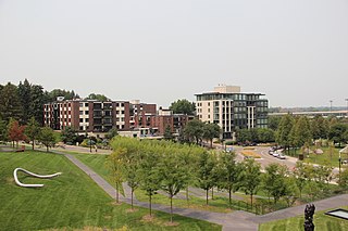
Uptown is a commercial district in southwestern Minneapolis, Minnesota, centered at the Uptown Theater at the intersection of Hennepin Avenue and Lagoon Avenue. It has traditionally spanned the corners of four neighborhoods, Lowry Hill East, ECCO, South Uptown and East Isles neighborhoods, within the Calhoun Isles community. Historically, the boundaries of Uptown are Bde Maka Ska to the west, Dupont Avenue to the east, 31st Street to the south, and 28th Street to the north.
The city of Minneapolis, Minnesota, United States is officially defined by the Minneapolis City Council as divided into eleven communities, each containing multiple official neighborhoods. Informally, there are city areas with colloquial labels. Residents may also group themselves by their city street suffixes, North, Northeast, South, Southeast, and Southwest.
Lowry Hill is a neighborhood within the Calhoun-Isles community in Minneapolis, Minnesota. The neighborhood is named for the terminal moraine on which it sits, a hill named after late nineteenth century real estate mogul and trolley tycoon Thomas Lowry. Its boundaries are Interstate 394 to the north, Interstate 94 to the east, Hennepin Avenue to the southeast, West 22nd Street to the south, Lake of the Isles Parkway to the southwest, and Logan Avenue South and Morgan Avenue South to the west. Lowry Hill is northwest of Lowry Hill East; the two neighborhoods are separated by Hennepin Avenue.

Lowry Hill Tunnel is a tunnel approximately 1600 ft in length accommodating the Interstate 94 (I-94) freeway near downtown Minneapolis, Minnesota that was completed in late 1971. It is placed at a near-right-angle turn in the highway, forcing the three lanes of traffic in each direction to slow down. The advised speed is 35 miles per hour (56 km/h).

Lowry Hill East is a neighborhood in southwest Minneapolis, Minnesota, United States, part of the Calhoun Isles community. It is bounded on the east by Lyndale Avenue, on the west by Hennepin Avenue and on the south by Lake Street. Lyndale and Hennepin intersect on the northern side at Interstate 94. This creates a neighborhood roughly triangular in shape, which is how it gets its nickname, "the Wedge." It is part of a larger area south of Franklin Avenue and west of Nicollet Avenue that is often considered Uptown, although officially Uptown is a smaller area centered on the intersection of Hennepin and Lake.
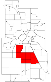
The Southwest Journal is an American, English language free community paper covering 21 neighborhoods in Southwest Minneapolis. It is family owned and was founded in 1990. It covers the following neighborhoods:

South Uptown is a residential neighborhood of Minneapolis, Minnesota. In 2018, the neighborhood voted to change its name to South Uptown from its former name CARAG. Other potential names for the neighborhood included "Bryant Park" and "Bryant Square". The Minneapolis City Council has not yet approved the change.

Lake Street is a major east-west thoroughfare in Minneapolis, Minnesota which is located between 29th and 31st Streets in south Minneapolis. It was named such because it runs through the Chain of Lakes area on the west side of town and passes over a small channel linking Bde Maka Ska and Lake of the Isles.
Minnesota State Highway 252 (MN 252) is a 4.353-mile-long (7.005 km) highway in Minnesota, which runs from its interchange with Interstate Highways 94 and 694 and US 52 in Brooklyn Center and continues north to its northern terminus at its interchange with State Highway 610 in Brooklyn Park. MN 252 generally follows not far from the west bank of the Mississippi River throughout its route.
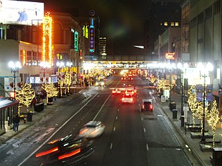
Hennepin Avenue is a major street in Minneapolis, Minnesota, United States. It runs from Lakewood Cemetery, north through the Uptown District of Southwest Minneapolis, through the Virginia Triangle, the former "Bottleneck" area west of Loring Park. It then goes through the North Loop in the city center, to Northeast Minneapolis and the city's eastern boundary, where it becomes Larpenteur Avenue as it enters Lauderdale in Ramsey County at Highway 280. Hennepin Avenue is a Minneapolis city street south/west of Washington Avenue, and is designated as Hennepin County Road 52 from Washington Avenue to the county line.

Lyndale is a neighborhood within the Powderhorn community in south Minneapolis, Minnesota, United States. Its boundaries are Lake Street to the north, Interstate 35W to the east, 36th Street to the south and Lyndale Avenue South to the west.

Lyn-Lake is a commercial district in south Minneapolis. At the core is the intersection of Lake Street and Lyndale Avenue from which Lyn-Lake takes its name. This is also at the intersection of four Minneapolis neighborhoods: Whittier on the northeast, Lyndale on the southeast, South Uptown on the southwest, and Lowry Hill East on the northwest. Most residents who consider themselves part of the "Lyn-Lake neighborhood" originate from the southeast corner of the Lyndale neighborhood. Lyn-Lake was branded by the Lyn-Lake Business Association in 1999.
Washington Avenue is a major thoroughfare in Minneapolis, Minnesota, United States. Starting north of Lowry Avenue, the street runs straight south, with Interstate 94 running alongside it until just south of West Broadway, when the freeway turns to the west. Washington continues running straight until just south of Plymouth Avenue, where it turns in a southeasterly direction heading for Downtown Minneapolis. It forms the main thoroughfare through the Warehouse District.

Lynnhurst is a neighborhood in the Southwest community in Minneapolis, Minnesota. Its boundaries are 46th Street to the north, Lyndale Avenue to the east, 54th Street to the south, and Penn Avenue to the west. It is located along the southeastern shore of Lake Harriet. Outflows from the lake run through a parkway for several city blocks to reach Minnehaha Creek.
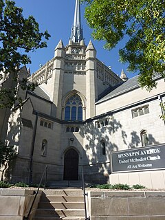
Hennepin Avenue United Methodist Church is a church across the Virginia Triangle from the Walker Art Center in Minneapolis, Minnesota. Its address is 511 Groveland Avenue.
Lyndale Avenue is a major street in Minneapolis, Brooklyn Center, Richfield, and Bloomington, Minnesota, in the United States. A noncontinuous portion exists in Faribault, part of Highway 21. There are several commercial districts along it, including Lyn-Lake in South Minneapolis, Shops at Lyndale in Richfield, and the Oxboro area in Bloomington. Portions of both Interstate 94 and Interstate 35 run on the right-of-way of Lyndale Avenue.
Powderhorn is a community in Minneapolis, which consists of eight different neighborhoods.
