Virginias

Last updated
The Virginias
Region
The Virginias.png
Country Flag of the United States.svg  United States of America
State Flag of Virginia.svg  Virginia
Flag of West Virginia.svg  West Virginia
Principal cities
Area
  Total67,004.97 sq mi (173,542.1 km2)
  Land63,528.30 sq mi (164,537.5 km2)
  Water3,476.67 sq mi (9,004.5 km2)
Population
 (2019) [1]
  Total10,327,666
  Density150/sq mi (60/km2)

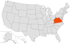
The Virginias (sometimes also known as the two Virginias) is a region in the United States comprising the U.S. states of Virginia and West Virginia. [2] If they were a single state (as they were until the Civil War), [3] the Virginias would have a combined population of 10,425,109 as of 2020 United States census. [4] [5] This would give Virginia the 10th-largest population of any state, with 14,000 people less than the 9th, North Carolina. The total area of the two states is about 175,000 square kilometers (67,000 square miles). [6]

Contents

Vexit

Vexit is a proposed measure for Second Amendment sanctuary counties in Virginia to secede and join the neighboring, more conservative West Virginia over the issue of gun legislation. [7]

See also

Related Research Articles

Southampton County, Virginia County in Virginia, United States

Southampton County is a county located on the southern border of the Commonwealth of Virginia. North Carolina is to the south. As of the 2020 census, the population was 17,996. Its county seat is Courtland.

Richland County, South Carolina County in South Carolina, United States

Richland County is located in the U.S. state of South Carolina. As of the 2020 census, the population was 416,147, making it the second-most populous county in South Carolina, behind only Greenville County. The county seat and largest city is Columbia, the state capital. The county was established on March 12, 1785. Richland County is part of the Columbia, SC Metropolitan Statistical Area. In 2010, the center of population of South Carolina was located in Richland County, in the city of Columbia.

Hampton County, South Carolina County in South Carolina, United States

Hampton County is a rural county located in the U.S. state of South Carolina. As of the 2020 census, the population was 18,561. Its county seat is Hampton. It was named for Confederate Civil War general Wade Hampton, who in the late 1870s, with the ending of Reconstruction, was elected as governor of South Carolina. The county includes two small urban clusters: Hampton and Estill (1,815).

Florence County, South Carolina County in South Carolina, United States

Florence County is a county located in the U.S. state of South Carolina. As of the 2020 census, its population was 137,059. Its county seat is Florence.

Cherokee County, South Carolina County in South Carolina, United States

Cherokee County is a county located in the U.S. state of South Carolina. As of the 2020 census, the population was 56,216. The county seat is Gaffney. The county was formed in 1897 from parts of York, Union, and Spartanburg Counties. It was named for the Cherokee people who historically occupied this area prior to European encounter.

Anderson County, South Carolina County in South Carolina, United States

Anderson County is a county located in the U.S. state of South Carolina. As of the 2020 census, its population was 203,718. Its county seat is Anderson. Named for Revolutionary War leader Robert Anderson, the county is located in northwestern South Carolina, along the state line of Georgia. Anderson County is included in the Greenville-Anderson-Mauldin, SC Metropolitan Statistical Area. Anderson County contains 55,950-acre (226 km2) Lake Hartwell, a U.S. Army Corps of Engineers lake with nearly 1,000 miles (2,000 km) of shoreline for residential and recreational use. The area is a growing industrial, commercial and tourist center. It is the home of Anderson University, a private, selective comprehensive university of approximately 3,000 undergraduate and graduate students.

Vance County, North Carolina County in North Carolina, United States

Vance County is a county located in the U.S. state of North Carolina. As of the 2020 census, the population was 42,578. Its county seat is Henderson.

Perquimans County, North Carolina County in North Carolina, United States

Perquimans County is a county located in the U.S. state of North Carolina. As of the 2020 Census, the population was 13,005. Its county seat is Hertford. The county was originally created as Berkeley Precinct. It was renamed Perquimans Precinct around 1684 and gained county status in 1739. Perquimans County is part of the Elizabeth City, NC Micropolitan Statistical Area, which is also included in the Virginia Beach-Norfolk, VA-NC Combined Statistical Area. The Harvey Point Defense Testing Activity facility is located in Perquimans County.

Pasquotank County, North Carolina County in North Carolina, United States

Pasquotank County is a county located in the U.S. state of North Carolina. As of the 2020 Census, the population was 40,568. Its county seat is Elizabeth City. The county was originally created as Pasquotank Precinct and gained county status in 1739. Pasquotank County is part of the Elizabeth City, NC Micropolitan Statistical Area, which is also included in the Virginia Beach-Norfolk, VA-NC Combined Statistical Area.

Martin County, North Carolina County in North Carolina, United States

Martin County is a county located in the U.S. state of North Carolina. As of the 2020 census, the population was 22,031. Its county seat is Williamston.

Caldwell County, North Carolina County in North Carolina, United States

Caldwell County is a county in the U.S. state of North Carolina. It is located in the foothills of the Blue Ridge Mountains. As of the 2020 census, the population was 80,652. Its county seat is Lenoir. Caldwell County is part of the Hickory–Lenoir–Morganton, NC Metropolitan Statistical Area.

Alleghany County, North Carolina County in North Carolina, United States

Alleghany County is a county located in the U.S. state of North Carolina. As of the 2020 Census, the population was 10,888. Its county seat is Sparta.

Sparta, North Carolina Town in North Carolina, United States

Sparta is a town in Alleghany County, North Carolina, United States. At the last 2010 census, the population was 1,770 people. It is the county seat of Alleghany County.

Louisburg, North Carolina Town in North Carolina, United States

Louisburg is a town in Franklin County, North Carolina, United States. As of the 2020 census, the town population was 3,064. It is the county seat of Franklin County. The town is located approximately 29 miles northeast of the state capital, Raleigh, and located about 31 miles south of the Virginia border. It is also the home of Louisburg College, the oldest two-year coeducational college in the United States.

Oxford, North Carolina Town in North Carolina, United States

Oxford is a town in Granville County, North Carolina, United States, with a population of 8,628 as of the 2020 census.. It is the county seat of Granville County.

Avinger, Texas Town in Texas, United States

Avinger is a town in Cass County, in the U.S. state of Texas. The population was 444 at the 2010 census, and 371 at the 2020 U.S. census. State Representative David Simpson, a Republican from Longview, served from 1993 to 1998 as the mayor of Avinger.

Dickens, Texas City in Texas, United States

Dickens is a city in and the county seat of Dickens County, Texas, United States. The population was 286 at the 2010 census, down from 332 at the 2000 census.

The Plains, Virginia Town in Virginia, United States

The Plains is a town in Fauquier County, Virginia, United States. The population was 245 as of the 2020 census, up from 217 at the 2010 census. It is centered on the intersection of VA 55 and VA 245. The town of The Plains is situated off I-66. As of 2022, the mayor of The Plains is Lori Sission.

Stone Ridge is a census-designated place in Loudoun County, Virginia, United States. Residences use Aldie mailing addresses, and it is near Washington Dulles International Airport. The population as of the 2010 census was 7,214. As of the 2020 census, the population had increased to 15,039. Stone Ridge is a Van Metre Homes planned, mixed-use community.

The demographics of Virginia are the various elements used to describe the population of the Commonwealth of Virginia and are studied by various government and non-government organizations. Virginia is the 12th-most populous state in the United States with over 8 million residents and is the 35th largest in area.

  1. "Population, Population Change, and Estimated Components of Population Change: April 1, 2010 to July 1, 2019 (NST-EST2019-alldata)". Census.gov. United States Census Bureau. Archived from the original on January 26, 2020. Retrieved 8 February 2020.
  2. Harris-Perry, Melissa (2010-04-08). "Two Virginias". ISSN   0027-8378 . Retrieved 2019-03-06.
  3. Gaddy, Kristina. "Why West Virginia Split from Virginia". Culture Trip. Retrieved 2019-03-06.
  4. "Explore Census Data". data.census.gov. Retrieved 2022-01-20.
  5. "Explore Census Data". data.census.gov. Retrieved 2022-01-20.
  6. Science, American Association for the Advancement of (1885-07-03). "Geology of the Virginias". Science. ns-6 (126): 17–18. doi:10.1126/science.ns-6.126.17. ISSN   0036-8075. PMID   17801321.
  7. Tyree, Elizabeth (2020-01-28). "VEXIT: West Virginia extends 158-year-old invitation for Va. localities to join state". WSET. Retrieved 2020-01-28.