
Rožanci is a suburban settlement of Belgrade, the capital of Serbia. It is located in the municipality of Barajevo.
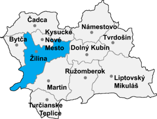
Gbeľany is a village and municipality in Žilina District in the Žilina Region of northern Slovakia.
Dickvale is a village in Oxford County, Maine, United States.

Cudniki is a village in the administrative district of Gmina Krośniewice, within Kutno County, Łódź Voivodeship, in central Poland. It lies approximately 5 kilometres (3 mi) south of Krośniewice, 16 km (10 mi) west of Kutno, and 53 km (33 mi) north-west of the regional capital Łódź.

Cənubi is a village in Baku, Azerbaijan.
Klew-Kolonia is a village in the administrative district of Gmina Żarnów, within Opoczno County, Łódź Voivodeship, in central Poland.
Nowa Gazomia is a village in the administrative district of Gmina Moszczenica, within Piotrków County, Łódź Voivodeship, in central Poland.
Wygon is a village in the administrative district of Gmina Biecz, within Gorlice County, Lesser Poland Voivodeship, in southern Poland. It lies approximately 7 kilometres (4 mi) north-west of Biecz, 15 km (9 mi) north of Gorlice, and 97 km (60 mi) east of the regional capital Kraków.
Dulcza Wielka is a village in the administrative district of Gmina Radomyśl Wielki, within Mielec County, Subcarpathian Voivodeship, in south-eastern Poland. It lies approximately 5 kilometres (3 mi) west of Radomyśl Wielki, 19 km (12 mi) south-west of Mielec, and 60 km (37 mi) west of the regional capital Rzeszów.
Brzozowo-Czary is a village in the administrative district of Gmina Dzierzgowo, within Mława County, Masovian Voivodeship, in east-central Poland.
Gradów is a village in the administrative district of Gmina Nowa Sucha, within Sochaczew County, Masovian Voivodeship, in east-central Poland.
Kolonia Gradowska is a village in the administrative district of Gmina Nowa Sucha, within Sochaczew County, Masovian Voivodeship, in east-central Poland.
Pluty is a village in the administrative district of Gmina Szydłowo, within Piła County, Greater Poland Voivodeship, in west-central Poland. It lies approximately 7 kilometres (4 mi) north-west of Szydłowo, 14 km (9 mi) north-west of Piła, and 94 km (58 mi) north of the regional capital Poznań.
Chojno is a village in the administrative district of Gmina Wronki, within Szamotuły County, Greater Poland Voivodeship, in west-central Poland. It lies approximately 12 kilometres (7 mi) west of Wronki, 28 km (17 mi) north-west of Szamotuły, and 59 km (37 mi) north-west of the regional capital Poznań.
Kaplica is a village in the administrative district of Gmina Somonino, within Kartuzy County, Pomeranian Voivodeship, in northern Poland. It lies approximately 8 kilometres (5 mi) south of Somonino, 14 km (9 mi) south of Kartuzy, and 35 km (22 mi) south-west of the regional capital Gdańsk.
Pastwiska is a settlement in the administrative district of Gmina Barciany, within Kętrzyn County, Warmian-Masurian Voivodeship, in northern Poland, close to the border with the Kaliningrad Oblast of Russia. It lies approximately 3 kilometres (2 mi) east of Barciany, 15 km (9 mi) north of Kętrzyn, and 76 km (47 mi) north-east of the regional capital Olsztyn.
Vodochody is a village and municipality in Prague-East District in the Central Bohemian Region of the Czech Republic. There is a small airport, Vodochody Airport, in the village and the aircraft construction company Aero Vodochody.
Valevac is a village in the municipality of Knjaževac, Serbia. According to the 2002 census, the village has a population of 281 people.
Pajkovac is a village in the municipality of Varvarin, Serbia. According to the 2002 census, the village has a population of 142 people.
Parcane is a village in the municipality of Varvarin, Serbia. According to the 2002 census, the village has a population of 542 people.


