The Amundsen Glacier is a major Antarctic glacier, about 7 to 11 km wide and 150 km (80 nmi) long. It originates on the Antarctic Plateau where it drains the area to the south and west of Nilsen Plateau, then descends through the Queen Maud Mountains to enter the Ross Ice Shelf just west of the MacDonald Nunataks.
The Prince Olav Mountains is a mountain group in the Queen Maud Mountains in Antarctica stretching from Shackleton Glacier to Liv Glacier at the head of the Ross Ice Shelf.

The Priestley Glacier is a major valley glacier, about 60 nautical miles long, originating at the edge of the Polar Plateau of Victoria Land, Antarctica. The glacier drains southeast between the Deep Freeze Range and Eisenhower Range to enter the northern end of the Nansen Ice Sheet. It was first explored by the Northern Party of the British Antarctic Expedition, 1910–13, and named for Raymond Priestley, a geologist with the Northern Party.
The Hauberg Mountains are a group of mountains of about 35 nautical miles extent, located 12 nautical miles north of Cape Zumberge and 30 nautical miles south of the Sweeney Mountains in eastern Ellsworth Land, Antarctica.

Bear Peninsula is a peninsula about 50 nautical miles long and 25 nautical miles wide which is ice-covered except for several isolated rock bluffs and outcrops along its margins, lying 3 nautical miles east of Martin Peninsula on Walgreen Coast, Marie Byrd Land, Antarctica.
Mikkelsen Bay is a bay, 15 nautical miles wide at its mouth and indenting 10 nautical miles, entered between Bertrand Ice Piedmont and Cape Berteaux along the west coast of Graham Land, Antarctica.

The Prince Charles Mountains are a major group of mountains in Mac. Robertson Land in Antarctica, including the Athos Range, the Porthos Range, and the Aramis Range. The highest peak is Mount Menzies, with a height of 3,228 m (10,591 ft). Other prominent peaks are Mount Izabelle and Mount Stinear. These mountains, together with other scattered peaks, form an arc about 420 km (260 mi) long, extending from the vicinity of Mount Starlight in the north to Goodspeed Nunataks in the south.
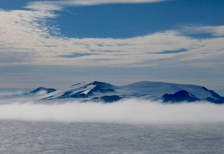
The Guest Peninsula is a snow-covered peninsula about 45 nautical miles long between the Sulzberger Ice Shelf and Block Bay, in the northwest part of Marie Byrd Land, Antarctica.
The Porthos Range is the second range south in the Prince Charles Mountains of Antarctica, extending for about 30 miles in an east-to-west direction between Scylla Glacier and Charybdis Glacier. First visited in December 1956 by the Australian National Antarctic Research Expeditions (ANARE) southern party under W.G. Bewsher (1956-57) and named after Porthos, a character in Alexandre Dumas, père's novel The Three Musketeers, the most popular book read on the southern journey.
On the continent of Antarctica, the Aramis Range is the third range south in the Prince Charles Mountains, situated 11 miles southeast of the Porthos Range and extending for about 30 miles in a southwest–northeast direction. It was first visited in January 1957 by Australian National Antarctic Research Expeditions (ANARE) southern party led by W.G. Bewsher, who named it for a character in Alexandre Dumas' novel The Three Musketeers, the most popular book read on the southern journey.

Wooden Peak is a peak 2 nautical miles (3.7 km) southeast of Black Head on Stresher Peninsula on the west coast of Graham Land. Charted by the British Graham Land Expedition (BGLE) under Rymill, 1934–37. Named by the United Kingdom Antarctic Place-Names Committee (UK-APC) in 1959 for Frederick E. Wooden, Falkland Islands Dependencies Survey (FIDS) surveyor at Danco Island in 1956 and at Prospect Point in 1957. Wooden was also attached to the British Naval Hydrographic Survey Unit which worked in the area in 1957–58.
The Anderson Hills are an irregular group of hills, ridges and peaks between Mackin Table and the Thomas Hills in the Patuxent Range, Pensacola Mountains, Antarctica.
Bryan Coast is that portion of the coast of Antarctica along the south shore of the Bellingshausen Sea between Pfrogner Point and the northern tip of the Rydberg Peninsula. To the west is Eights Coast, and to the east is English Coast.
The Demas Range is a range about 8 nautical miles long that forms the lower east margin of the Berry Glacier in Marie Byrd Land, Antarctica. The range trends north–south culminating in Mount Goorhigian, 1,115 metres (3,658 ft) high.

Drummond Glacier is a glacier 10 nautical miles (18 km) long and 2 nautical miles (4 km) wide, on the west coast of Graham Land, situated south of Hopkins Glacier and flowing west-northwest between Voit Peak and Sherba Ridge into Darbel Bay east of Sokol Point.
Mobiloil Inlet is an ice-filled inlet, nurtured by several northeast and east flowing glaciers, lying between the Rock Pile Peaks and Hollick-Kenyon Peninsula along the east coast of the Antarctic Peninsula.

The Goodenough Glacier is a broad sweeping glacier to the south of the Batterbee Mountains, flowing from the west shore of Palmer Land, Antarctica, into George VI Sound and the George VI Ice Shelf.
The Matsuyama Rocks are a small group of rocks close off the west side of Stefan Ice Piedmont, Graham Land, Antarctica. They are located towards the western end of Crystal Sound. They were mapped from air photos taken by the Falkland Islands and Dependencies Aerial Survey Expedition (1956–57), and were named by the UK Antarctic Place-Names Committee after Motonori Matsuyama, Professor of Geology and Geophysics at Kyoto University, Japan, who made laboratory studies of the crystal forms of ice.
Ramsey Glacier is a glacier about 45 nautical miles long in Antarctica. It originates in the Bush Mountains near the edge of the polar plateau and flows north through the Queen Maud Mountains of Antarctica to the Ross Ice Shelf eastward of Den Hartog Peak.
Roberts Massif is a remarkable snow-free massif at the head of Shackleton Glacier. It rises to over 2,700 metres (8,900 ft) and is about 60 square nautical miles in area.