
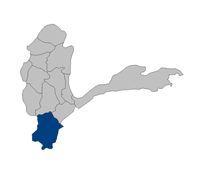
Jurm District is one of the 28 districts of Badakhshan Province in northeast Afghanistan. The district capital is a town named Jurm. The district is 3 hours from the center of the province in Fayzabad, and is home to approximately 3,000 residents, making it one of the most sparsely populated portions of the province. The highest point of the Afghan Hindu Kush is located in Jurm District, at 6729 meters. The district consist of clusters and villages. Ferghamenj, Kyb, Kyteb, Ularyb,Ferghameru, Khustak, and Iskan are the clusters. Each cluster contain villages; the district is largely Tajik speaking.

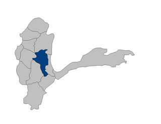
Darayim is a district in Badakhshan Province, Afghanistan. It was created in 2005 from part of Fayzabad District and is home to approximately 65,000 residents.
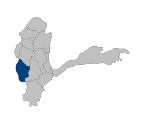
Khash District is one of the 28 districts of Badakhshan Province, Afghanistan. It was created in 2005 from part of Jurm District and is home to approximately 48,000 residents, making it the third most populous district of the province.

Kohistan District is one of the 29 districts of Badakhshan Province in eastern Afghanistan. It was created in 1995 from part of Ragh District and is home to approximately 35,000 residents.
Tagab District is one of the 29 districts of Badakhshan Province in Afghanistan. It was created in 2005 from part of Fayzabad District and has a population of approximately 22,000 residents. The Karaste Canal is located in Tagab District.
Yaftal Sufla is one of the 29 districts of Badakhshan Province in eastern Afghanistan. It was created in 2005 from part of the Fayzabad District and is home to approximately 39,000 residents.
Yamgan District is one of the 29 districts of Badakhshan Province in eastern Afghanistan. It was created in 2005 from part of the Baharak District and is home to approximately 20,000 residents, mostly Ismailis.
Yawan District is one of the 28 districts of Badakhshan Province in eastern Afghanistan. It was created in 2005 from part of the Ragh District and is home to approximately 20,000 residents.
Baharak district is a district of Badakhshan Province, Afghanistan located about 30 km southeast of Fayzabad. The capital is the city of Baharak and the district is home to approximately 14,000 residents. The district is also called Baharistan.
Kishim District is one of the 29 districts of Badakhshan Province in eastern Afghanistan. The district is located in the Keshem Valley, a primarily rural area on the western edge of the province, and is home to approximately 63,000 residents, making it the second most populous district of the province.
Kuran wa Munjan District is one of the 28 districts of Badakhshan Province in eastern Afghanistan. Located in the Hindu Kush mountains, the district is home to approximately 8,000 residents. The district administrative center is Kuran wa Munjan.
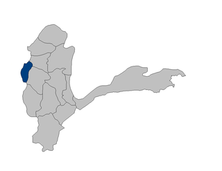
Shahri Buzurg District is one of the 28 districts of Badakhshan Province in eastern Afghanistan. The capital is the city of Shahri Buzurg. Its northwestern border is along the international border between Afghanistan and Tajikistan while its southwestern border is with Takhar Province. Located on the western edge of the province, Shahri Buzurg hosts a population of approximately 42,000 residents.

Khwahan District, is one of the 28 districts of Badakhshan Province, located in northeastern Afghanistan. The district capital is Khwahan. The population of the district is approximately 27,000. The district borders Raghistan to the southwest, Kuf Ab in the northeast, the Panj River in the northwest, and Shuro-obod district, Khatlon Province, of Tajikistan. Kuh-e kallat

Bārīkī Persian: باریکی is a village in Khwahan Badakhshan Province in north-eastern Afghanistan.

Darwaz district was a district in Badakhshan Province in Afghanistan until 2005. It was part of the historic region Darwaz which is now divided between Afghanistan and Tajikistan. In 2005 Darwaz District was subdivided into Maimay District, Darwazi Bala District, and Shekay District. Some maps use the name Darwaz for Maimay District. The district was historically part of the Darvaz principality, a semi-independent statelet ruled by a mir.
The Anjuman Pass is a mountain pass in the Hindu Kush in Afghanistan. It connects the Panjshir Valley to the south to Badakhshan to the north, which is the most north-easterly province of Afghanistan.
Bid Khvah Persian: بید خواه is a village in Khwahan Badakhshan Province in north-eastern Afghanistan.
Kowl Darrah or Kowl Darreh Persian: کولدره is a village in Khwahan of Badakhshan Province in north-eastern Afghanistan.
Badakhshan University is located in Badakhshan province, northeastern Afghanistan.


