
The French Southern and Antarctic Lands is an overseas territory of France. It consists of:
- Kerguelen Islands, a group of volcanic islands in the southern Indian Ocean, southeast of Africa, approximately equidistant between Africa, Antarctica and Australia;
- St. Paul and Amsterdam islands, a group to the north of Kerguelen;
- Crozet Islands, a group in the southern Indian Ocean, south of Madagascar;
- Adélie Land, the French claim on the continent of Antarctica;
- the Scattered Islands, a dispersed group of islands around the coast of Madagascar.
The Kerguelen Islands, also known as the Desolation Islands, are a group of islands in the Antarctic constituting one of the two exposed parts of the Kerguelen Plateau, a large igneous province mostly submerged by the southern Indian Ocean. They are among the most isolated places on Earth, located 450 km (280 mi) northwest of the uninhabited Heard Island and McDonald Islands (Australia) and more than 3,300 km (2,100 mi) from Madagascar, the nearest populated location. The islands, along with Adélie Land, the Crozet Islands, Amsterdam and Saint Paul Islands, and France's Scattered Islands in the Indian Ocean, are part of the French Southern and Antarctic Lands and are administered as a separate district.
Grande Terre or Grande-Terre is a generic term used in French to designate the main island of any given archipelago. As a specific toponym, it may refer to the following:

The Kerguelen Plateau is an oceanic plateau and a large igneous province (LIP) located on the Antarctic Plate, in the southern Indian Ocean. It is also a microcontinent and submerged continent. It is about 3,000 km (1,900 mi) to the southwest of Australia and is nearly three times the size of Japan. The plateau extends for more than 2,200 km (1,400 mi) in a northwest–southeast direction and lies in deep water.

Mont Ross is a stratovolcano, the highest mountain in the Kerguelen Islands at 1,850 metres (6,070 ft). It is located in the Gallieni Massif, at the end of the Gallieni Peninsula, east of Baie Larose on the main island of Grande Terre. The volcano is composed primarily of trachybasalt and was active during the late Pleistocene.
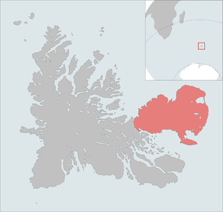
The Courbet Peninsula is a peninsula in northeastern Grande Terre Island, the main island of the subantarctic Kerguelen Archipelago, Southern Indian Ocean. In the south of the peninsula is Port-aux-Français, the principal station of the archipelago.
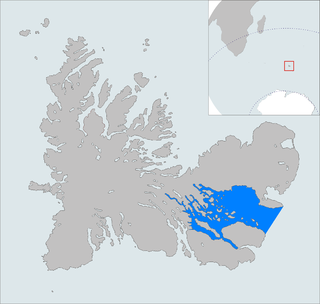
The Golfe du Morbihan is a bay on the eastern coast of Grande Terre, the largest of the Kerguelen islands. It forms a deep and broad notch in the central section of the island.

The Rallier du Baty Peninsula is a peninsula of Grande Terre, the main island of the subantarctic Kerguelen archipelago in the southern Indian Ocean. It occupies the south-western corner of the island, and is about 35 km long, extending from north to south, and 25 km across at its widest. The 1,202 m high Bicorne rises in the southern coast of the peninsula. It is named for Raymond Rallier du Baty, a French sailor who charted the archipelago in the early 20th century. The Îles Boynes, France's southernmost land apart from Adélie Land in Antarctica, lie 30 km south of the tip of the peninsula.

The French Southern and Antarctic Territories is a French overseas territory consisting of Adélie Land in coastal Antarctica and several islands in the southern Indian Ocean: the Crozet Islands, the Kerguelen Islands, Amsterdam Island and Île Saint-Paul. The territory was created on 6 August 1955, before which all were dependencies of Madagascar.

Péninsule Jeanne d'Arc, also known as Presqu'île Jeanne d'Arc, is a peninsula of Grande Terre, the main island of the subantarctic Kerguelen archipelago in the southern Indian Ocean.
The Péninsule Loranchet, also known as Presqu'île Loranchet, is a peninsula of Grande Terre, the main island of the subantarctic Kerguelen archipelago in the southern Indian Ocean.

Baie Larose, or Larose Bay in English, is a bay of Grande Terre, the main island of the subantarctic Kerguelen archipelago, a French territory in the southern Indian Ocean. It is important as a breeding site for seabirds, especially penguins.
The Îles Leygues, or Leygues Islands, also sometimes known as the Îles Swain, comprise a group of small islands and islets that are part of the subantarctic Kerguelen archipelago, a French territory in the southern Indian Ocean.
The Îles Nuageuses comprise a group of small islands that are part of the subantarctic Kerguelen archipelago, a French territory in the southern Indian Ocean. They are important as a breeding site for seabirds, especially penguins and albatrosses, and for fur seals.

Île du Port is one of the Kerguelen Islands situated in the Golfe des Baleiniers off the north coast of Grande Terre, the main island.

The Île de l'Ouest is one of the Kerguelen Islands situated near to the west coast of Grande Terre, the principal island.

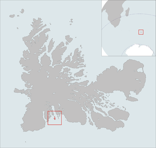
Île Haute is one of the Kerguelen Islands situated in the Golfe du Morbihan near the coast of Grande Terre, the principal island.
Îles du Prince-de-Monaco is a small a group of islands belonging to the Kerguelen Islands and situated near the coast of Grande Terre, the principal island.

The Gallieni Massif is a mountain range in Grande Terre, the main island of Kerguelen in the French Southern Territories zone of the Southern Indian Ocean.

Lake Armor is a French fjord lake located on the central plateau of the main island of the Kerguelen archipelago, in the French Southern and Antarctic Lands.

