Numerous information boards, photographs and exhibits from the Volcanic Eifel, as well as of currently active volcanoes in Europe and Asia, offer insights into the geological development of the Volcanic Eifel region.
In addition there are several other volcano museums that cover the Eifel, such as the Maar Museum in Manderscheid and the Volcano House, Strohn.
Exhibits
In the exhibition rooms are interactive computer models about the geology and volcanism of the Eifel. On a large overview map at the entrance, the phenomena of continental movement (plate tectonics) is explained, and currently active volcanoes can be viewed by means of fluorescent lights. A computer simulation shows the distribution of the continents in the geological eras of the past and also in the future. Other exhibits explain the origin and evolution of the rocks. In the exhibition room "Eifel Volcanism" the visitor can even simulate a volcanic eruption using a model of a cinder cone.
Other models show the entire region of the volcanic West Eifel and the formation of volcano types in Eifel region. The models are supplemented in turn by numerous exhibits from the Volcanic Eifel. In the Volcanic Eifel Geo Centre all the geologically-related facilities of the Volcanic Eifel are summarized on an information board. These include the Devonian Route, the Bunter Sandstone Route, the Volcano Route, the Mineral Spring Route as well as mining and other museum facilities. Once again, visitors can illuminate geologically interesting places on a clear wall map using buttons. In the basement of the museum, the training centre of the Geo Centre offers a wide range of media and exhibits relating to geology.
Literature
Werner P. D´hein: Vulkanland Eifel. Natur- und Kulturführer, mit 26 Stationen der "Deutschen Vulkanstraße". Gaasterland-Verlag, Düsseldorf, 2006, ISBN3-935873-15-8, ISBN978-3-935873-15-4
The Eifel is a low mountain range in western Germany, eastern Belgium and northern Luxembourg. It occupies parts of southwestern North Rhine-Westphalia, northwestern Rhineland-Palatinate and the southern area of the German-speaking Community of Belgium.
The Ring of Fire is a tectonic belt of volcanoes and earthquakes.
Vulkaneifel is a district (Kreis) in the northwest of the state Rhineland-Palatinate, Germany. It is the least densely populated district in the state and the fourth most sparsely populated district in Germany. The administrative centre of the district is in Daun. Neighboring districts are Euskirchen, Ahrweiler, Mayen-Koblenz, Cochem-Zell, Bernkastel-Wittlich, and Bitburg-Prüm.
The Taupō Volcanic Zone (TVZ) is a volcanic area in the North Island of New Zealand. It has been active for at least the past two million years and is still highly active.
Mount Asama is an active complex volcano in central Honshū, the main island of Japan. The volcano is the most active on Honshū. The Japan Meteorological Agency classifies Mount Asama as rank A. It stands 2,568 metres (8,425 ft) above sea level on the border of Gunma and Nagano prefectures. It is included in 100 Famous Japanese Mountains.
Mount Aso or Aso Volcano is the largest active volcano in Japan and among the largest in the world. Common use relates often only to the somma volcano in the centre of Aso Caldera. It stands in Aso Kujū National Park in Kumamoto Prefecture, on the island of Kyushu. Its tallest peak, Takadake, is 1,592 meters (5,223 ft) above sea level. Mount Aso is in a fairly large caldera with a circumference of around 120 km (75 mi), although sources vary on the exact distance.
A maar is a broad, low-relief volcanic crater caused by a phreatomagmatic eruption. A maar characteristically fills with water to form a relatively shallow crater lake, which may also be called a maar.
The Trans-Mexican Volcanic Belt, also known as the Transvolcanic Belt and locally as the Sierra Nevada, is an active volcanic belt that covers central-southern Mexico. Several of its highest peaks have snow all year long, and during clear weather, they are visible to a large percentage of those who live on the many high plateaus from which these volcanoes rise.
Sangay is an active stratovolcano in central Ecuador. It exhibits mostly strombolian activity. Geologically, Sangay marks the southern boundary of the Northern Volcanic Zone, and its position straddling two major pieces of crust accounts for its high level of activity. Sangay's approximately 500,000-year-old history is one of instability; two previous versions of the mountain were destroyed in massive flank collapses, evidence of which still litters its surroundings today.
The Central American Volcanic Arc is a chain of volcanoes which extends parallel to the Pacific coastline of the Central American Isthmus, from Mexico to Panama. This volcanic arc, which has a length of 1,100 kilometers (680 mi) is formed by an active subduction zone, with the Cocos plate subducting underneath the Caribbean plate, the North American plate and the Panama plate. Volcanic activity is recorded in the Central American region since the Permian. Numerous volcanoes are spread throughout various Central American countries; many have been active in the geologic past, varying in intensity of their activity according to different factors.
The surface of Venus is dominated by volcanic features and has more volcanoes than any other planet in the Solar System. It has a surface that is 90% basalt, and about 65% of the planet consists of a mosaic of volcanic lava plains, indicating that volcanism played a major role in shaping its surface. There are more than 1,000 volcanic structures and possible periodic resurfacing of Venus by floods of lava. The planet may have had a major global resurfacing event about 500 million years ago, from what scientists can tell from the density of impact craters on the surface. Venus has an atmosphere rich in carbon dioxide, with a pressure that is 90 times that of Earth's atmosphere.
The Eifel hotspot is a volcanic hotspot in Western Germany. It is one of many recent volcanic formations in and around the Eifel mountain range and includes the volcanic field known as Volcanic Eifel. Although the last eruption occurred around 10,000 years ago, the presence of escaping volcanic gases in the region indicates that it is still weakly active.
The National Polytechnic School, also known as EPN, is a public university in Quito, Ecuador. The campus, named after José Rubén Orellana, is located in the east-central part of Quito. It occupies an area of 15.2 hectares and has a built area of around 62,000 metres2. Its student body numbers approximately 10,000, of which thirty percent are women. The main campus encompasses ten teaching and research faculties, in addition to four technical and specialized institutes. EPN was founded in 1869 with the aim of becoming the first technical and technological center in the country. Since its beginnings, EPN adopted the polytechnic university model, which stresses laboratory instruction in applied science and engineering. At the campus, there are some libraries with content primarily oriented to engineering and scientific topics.
The Volcanic Eifel or Vulkan Eifel, also known as the East Eifel Volcanic Field (EEVF), is a region in the Eifel Mountains in Germany that is defined to a large extent by its volcanic geological history. Characteristic of this volcanic field are its typical explosion crater lakes or maars, and numerous other signs of volcanic activity such as volcanic tuffs, lava streams and volcanic craters like the Laacher See. The Volcanic Eifel is still volcanically active today. One sign of this activity is the escaping gases in the Laacher See.
The Volcano Park in Mayen-Koblenz is a geopark in the rural district of Mayen-Koblenz in the eastern Vulkan Eifel, Germany. It was founded in 1996 and wraps around the Laacher See. Together with the Volcano Park, Brohltal/Laacher See and the Vulkan Eifel Nature and Geo-Park, it forms part of the national Eifel Volcano Land Geo-Park. The three parks are connected by the 280-kilometre-long German Volcano Route.
Devana Chasma is a weak extensional rift zone on Venus, with a length of 4000 km, a width of 150–250 km, and a depth reaching 5 km. Most of the faults are facing north–south. The rift is located in Beta Regio, a 3000 km rise created by volcanic activity. Mantle plumes rising from the bottom are the reason behind the formation of the rift zone. The slow extension rates in the rift may be driven by the same reason.
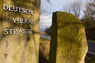
The German Volcano Route or, less commonly, German Volcano Road is a 280-kilometre-long tourist route from the River Rhine to the mountains of the High Eifel. It links 39 sites within the Geopark Vulkanland Eifel in the Volcanic Eifel (Vulkaneifel), at which geological, cultural-historical and industrial-historical nature and cultural monuments on the subject of volcanicity in the Eifel are located.
The Vulkanland Eifel Geopark is a German national geopark in the Volcanic Eifel region that was established on 19 April 2005. Covering an area of 2,200 km2, the geopark extends from the Belgian border in the west over the Eifel mountains to the River Rhine in the east. The countryside here which has been shaped by the volcanism of the past contains numerous maars, cinder cones, lava flows lava domes calderas and bubbling springs. The largest caldera was formed by the Laacher See volcano that last erupted about 13,000 years ago. A sign of continuing volcanic activity in this region are the volcanic gases that are still visibly being discharged into the atmosphere.
Hveravellir is a geothermal field of the Oddnýjarhnjúkur-Langjökull volcanic system -Icelandic pronunciation:[ˈlauŋkˌjœːkʏtl̥] in the north of the Langjökull glacier.
This page is based on this Wikipedia article Text is available under the CC BY-SA 4.0 license; additional terms may apply. Images, videos and audio are available under their respective licenses.